![]() The Geography of New Orleans
The Geography of New Orleans![]()
![]()
![]()
![]()
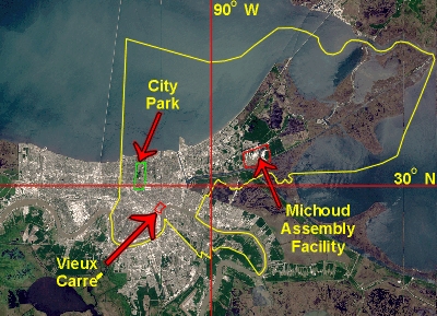 The City of New Orleans is located exactly at 90 degrees west longitude, and 30 degrees north latitude. Actually, the exact coordinate lies in the marshes of New Orleans East, just southwest of NASA's Michoud Assembly Facility. The Vieux Carre', the original city built by Bienville (also known as the French Quarter), presides over a huge 90 degree curve in the Mississippi River some 110 miles north of its confluence with the Gulf of Mexico. The city limits of New Orleans are co-terminous with the boundaries of Orleans Parish (outlined in yellow in the photo-map at left). However, as can be seen in the photo-map, the metropolitan area of the city has grown well beyond these boundaries. In just under three hundred years, New Orleans has grown from the one-square mile settlement founded by Bienville to cover parts of four parishes in southeastern Louisiana.
At this location, New Orleans teeters on the edge of the continental shelf of North America. Geologically speaking, it wasn't too long ago that the area now known as Louisiana was submerged under a huge embankment of the Gulf of Mexico. The Mississippi slowly, over a period of millions of years, began depositing silt along the ocean's bottom, until eventually land began to break its waves. About 1 million years ago, the river had built up for itself a fragile delta extending out into the gulf. A battle between the river and the sea ensued that was much like a game of tug-of-war, and the river barely won. As the layers upon layers of silt slowly pushed back the gulf's waves, the river continued to build up the land in a huge fan-shaped delta extending from lower Illinois to Louisiana and Mississippi. A new layer of silt was deposited with each successive spring flood. Where once the Gulf jutted up into the heart of the North American continent, today the Mississippi juts out a hundred and fifty or so miles into the Gulf. However, due to the effects of man's efforts, the Mississippi is doomed to lose this geological game of tug-of-war.
The Mississippi River deposits more silt closer to its banks during the spring floods. For that reason, the land is higher closer to the river. As one moves away from the river's edge, the land sinks to about 5 to 10 feet below sea level, maybe higher in some places. Because the river deposits more silt closer to its banks, the riverbed itself has been built up so much that the river's surface is actually higher than the surrounding land at about 11 feet above sea level. Only the natural levee along its banks is higher than the river's surface, and since the levee is only a foot or two higher than the river's surface, the river is naturally prone to overflow this levee and inundate the low land around it. Because of this, the U.S. Army Corps of Engineers has extended the height of this natural levee in an attempt to keep the river within its natural course. Tourists in Jackson Square delight in sitting on a bench just a few feet above sea level and looking up at the river's traffic floating 11 feet higher. Ships travelling down the Mississippi appear to hover over the city below.
The Mississippi's present riverbed at New Orleans is only about 1000 years old. Before that, the river flowed a few miles to the north through what is today Metairie, Mid City, and Gentilly. When the river retreated to its present course, it left behind a series of small bayous. These were called Metairie Bayou, Bayou St. John, and Gentilly Bayou by the early French explorers. Though Metairie and Gentilly Bayous have long since silted up and disappeared, the natural levee along the old river's bed remained, creating a causeway through the murky swamp known as the Metairie Ridge and the Gentilly Ridge. Indians, and later Europeans, used these ridges as a portage through the swamp. The Indians built their villages upon them, and farmed their rich soil. Today, the Metairie Ridge and Gentilly Ridge can still be located on a street map of the modern city and are labelled as "Metairie Road" and "Gentilly Boulevard". The name Le Metairie that is given to New Orleans' western suburb is French meaning "The Little Farms".
 Lake Pontchartrain and Lake Maurepas were created about 5000 years ago, at the end of the last Ice Age. As the polar ice cap retreated, the melted ice raised the sea level. The area that is now inundated by these two lakes was very low, perhaps as much as ten to twenty feet below the surrounding land. Like the rest of the land, swampy forests inhabited by alligators, water moccasins and swarms of mosquitoes covered the area. As the sea level rose, the Gulf of Mexico overflowed into this bowl of swampy land. Today, Lake Maurepas empties into Lake Pontchartrain through Pass Manchac, which in turn empties into the Gulf through a narrow and shallow channel called the Rigolets (Rig-a-lees). Lake Pontchartrain's surface is normally about 2 feet above sea level. Like the river, it is normally kept out of the city below it by a natural levee that has been built up around its banks. During storms, the lake is prone to overflow the levees. Because of this, the U.S. Corps of Engineers has built up the height of the natural levees much like it has done along the river's banks and has also built a flood wall of about 14 feet for extra protection. During a hurricane, should these levees and flood walls ever fail, New Orleans will be inundated by salty water.
The land between the lake and the river is occupied by the streets, homes, and businesses of the city. Remember that the river is about 11 feet above the sea level and the lake is about 2 feet above sea level. The land immediately bordering the banks of both the river and the lake are naturally only mere feet above the water's surface. From there, it sinks almost imperceptibly to a depth of about 10 feet below sea level in some places. (The cross section elevation diagram below is distorted vertically in order to highlight the elevation differences throughout the city.) Between the natural levee of the river and that of the lake, only Metairie Ridge and Gentilly Ridge lie above sea level and that is only by about a feet or more. This means that the city lies below its surrounding waters like a bowl waiting to be filled. Therefore, during the river's spring high-water season and hurricanes the city is extremely susceptible to floods.
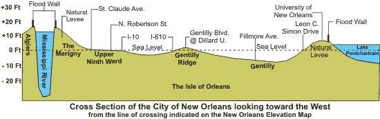
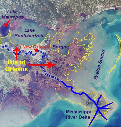 When the French arrived at the end of the 17th century, they were greeted by this swampy land that they called Le Flottant (the Floating Land). Their description was not far from the truth. The land is naturally very wet, even spongy. A person must dig through twenty feet of land through a hole that would quickly drown him as it filled up with water before he reached what can be loosely termed "solid ground". He'd have to dig another 80 feet before he reached bedrock consisting of compacted clay, and silty sand. For this reason all structures of any significance must be built on pilings hammered deep into the ground. Skyscrapers are a new feature to the city's landscape, as these require pilings of thick concrete set more than a hundred feet into the ground. Such is the nature of a low-lying alluvial plain such as the Mississippi River delta. Surrounding this Floating Land on all sides is water, lots and lots of water. The French saw the land as an island, which they named the Isle d'Orleans (Isle of Orleans). The Isle d'Orleans soon became a political and regional entity with geographic boundaries. These boundaries (outlined in yellow on the photo-map at left) were identified by the French as the Mississippi River on the west and south, Lake Pontchartrain and Lake Maurepas on the north, Breton Sound (part of the Gulf of Mexico) on the east, and what the French named the Iberville River (that connected the Mississippi at Baton Rouge to Lakes Maurepas and Pontchartrain) to the northwest. This area is on the east bank of the Mississippi River. However, throughout Louisiana's history - after the territory was divided along the river itself, and only that part of the original territory west of the river was known as Louisiana - the Isle of Orleans remained a part of the Lousiana Territory.
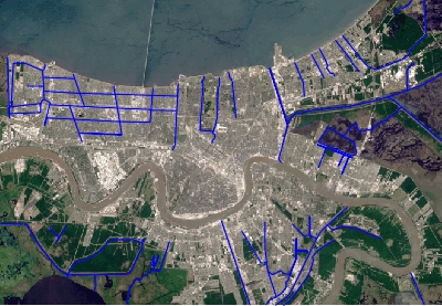 Beginning in the latter part of the 19th century, and continuing on into the 20th, New Orleanians began a concerted project to drain the Isle of Orleans of its shallow swamp. Dry land is a valuable commodity in southeast Louisiana. As the city of New Orleans grew more of it was needed. All of the high land along the river's bank had long since been claimed and developed, but more was needed. In order to reclaim the swamp, a series of canals and pumping stations were built. The pumping stations were able to drain hundreds of square miles of swampland, pumping the excess water into Lake Pontchartrain to the north of the city and into the swamps and bayous to the south, thus leaving behind a dry, yet still spongy prairie upon which the city could sprawl. As can be seen in the photo-map above, the system of canals drains the land farthest away from the River. These are the lowest areas within the city, lying below sea level and naturally covered by shallow marshes and swamps. No canals are needed to drain the land close to the river's banks since the river has built up this land to an elevation a few feet or more above sea level. As water must flow down, the canals drain into the Lake and bayous surrounding the city instead of into the River itself, as one might expect. The few canals that do empty into the River are connected to it in order to allow barge traffic to pass through them.
The area that has since been drained by the canal system includes most of the present metropolitan area of New Orleans, including almost all of Orleans Parish (except the most eastern portions of that parish), the northern half of Jefferson Parish to an area just south of the cities of Westwego and Gretna, the northeastern corner of St. Charles Parish, the western portion of St. Bernard Parish, and the northern tip of Plaquermines Parish. Today, the series of canals and pumping stations continue to keep the land dry. Throughout the rainy season, they pump massive quantities of water out of the area into Lake Pontchartrain. In spite of this, the wetness of Louisiana proves, from time to time, to be too much for the pumps, and floods occur. However, not since 1927 has New Orleans flooded because of the height of the Mississippi or the lake. Added to the pumps' strength is a system of levees that completely surround the city. These levees are built on top of the natural levee built by the river and the lake over thousands of years. Flood walls on top of the levees heighten the protection to about 20 feet above sea level. Yet, even levees and flood walls could fail if the river got extremely high during the spring. Therefore, The Bonnie Carre Spillway, built by the U.S. Army Corps of Engineers in St. Charles Parish allows floodwaters of the Mississippi to be diverted into Lake Pontchartrain, sparing the city of New Orleans from river floods. Most of the floods of the 20th century have been due to sustained periods of heavy rainfall and hurricanes. Yet, as beneficial as this system is to the city, inevitably it will spell New Orleans' doom. The levee system that has been built along the river, coupled with the canal system to keep the interior of the city dry, prevent the land from being replenished by the annual spring floods. As a result, the land will continue to sink until eventually there will be nothing to stop the waters of the Gulf to rush back upon the fragile land. In addition, the fresh water that is pumped into the brackish wetlands surrounding the city is creating an ecological disaster. When the Bonnie Carre Spillway is used in order to spare the city of New Orleans from floods, the consequences to the coastal estuary system is profound. As a result, in order to save itself from the waters surrounding it, the city of New Orleans is slowly destroying its own environment. The final death knoll of the city may very well come from the river itself. Scientists and environmentalists know that the Mississippi is trying to change its course that will bypass the city in favor of the shorter route to the Gulf through the Atchafalaya basin. So far, the Corps of Engineers has prevented the river from doing this. But, one day, it will happen, perhaps following a direct hit from a hurricane. As late summer and early fall approach every year (hurricane season), New Orleans stands with the threat that it will lose its own lifeline. No canal system and no levee system will prevent the disaster that will follow.
The photo-maps used on this page have been produced using images of the City of New Orleans taken aboard manned-space flights published by NASA.
© 1999 - 2003 by SouthBear