|
|
| Mica
Mountain |
 |
| Height: |
8,666 feet (2,641 meters) |
| Location: |
Arizona, United States, North America |
| Lat/Lon: |
32.22ºN, 110.54ºW |
| Maintainer:
|
streeyyr -- View Contributors |
| Last Edited:
|
Mar 23, 2005 | |
 |
|
|
Page Quality:  (3 votes, 118 hits) -- Rate This Page | View Votes/Comments (3 votes, 118 hits) -- Rate This Page | View Votes/Comments |
| If you have some
info that could help to improve this page, click on the "Add
Info" link next to the appropriate section below. |
|
|
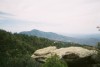
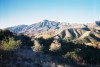
Mica Mountain is
the highpoint of the Rincon Mountains. The Rincon Mountains are
located just east of Tucson, and together with Mount Lemmon,
comprise a formidable barrier on the north and east sides of the
city. The Rincon Mountains are located in Saguaro National Park and
the Coronado National Forest. Mica Mountain itself is located in the
Rincon Mountain District of Saguaro National Park. Other high peaks
in the Rincons include the 8,482' Rincon Peak, and the 7,049' Tanque
Verde Peak. Mica Mountain has a prominence of 4,608'.
Mica
Mountain is a huge mountain. The mountain towers nearly 6,300' above
downtown Tucson. However, like many desert mountains, it doesn't get
much respect. Mica Mountain isn't a very scenic mountain, and
certainly isn't picturesque like many other mountains in the western
US. It has a gentle, rounded summit with no views, and there are
many fine trails leading into the Rincons. The city of Tucson lies
just a few miles away, so many climbers probably think Mica isn't a
worthy mountain. But Mica Mountain most certainly is a worthy
mountain. A climb of Mica Mountain from almost any direction will
involve long distances and high elevation gains, and will test the
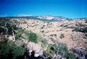
endurance of almost any climber. The mountain is located within the
59,930-acre Saguaro Wilderness Area, so the mountain is more remote
than most people think, especially if you enter the wilderness area
from the southeast. The high elevations of the Rincons have scrub
oak, Ponderosa Pine, and Douglas Fir, which are more reminiscent of
the Pacific Northwest than the Desert Southwest. Climbers will
travel through several different life zones on the way to the top,
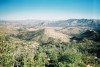
which will keep things interesting. Although the summit of Mica
Mountain has no views, the nearby Spud Rock affords great views of
Tucson and the surrounding area. Climbers can also combine Mica
Mountain and the nearby Rincon Peak into a weekend backpacking trip,
which would have to be considered a significant achievement for
almost anyone. In short, Mica Mountain has many things to offer. For
those interested in seeing the Sonoran desert landscape, the 8-mile
long Cactus Forest Drive winds through the heart of an extensive
saguaro forest. This paved road starts at the Saguaro National Park
Visitor Center. Mica Mountain was named for the numerous Mica rock
deposits that are located on the mountain.
There are at
least three ways to approach Mica Mountain. You can approach it from
Tucson via Speedway Boulevard, and take the Douglas Springs Trail.
You can approach it from the north via Forest Roads 4417 and 4424,
and take Forest Trail 95 to the top. Or, you can come in from the
southeast via Forest Roads 35 and 4408, and take the Turkey Creek
Trail.
No passes or
permits required. No trailhead parking fees.
Mica Mountain
can be climbed year-round. However, spring and fall are the best
times. The summers here can be very hot, and the Rincons can hold
snow in the winter.
Backcountry
camping is allowed in the Rincon Mountain District. A fee of $6 is
charged each night, and permits may be purchased at the Visitor
Center. There are six wilderness campgrounds, all accessible by
horse or foot, and all are located at least six miles from the
nearest trailhead. Water is available seasonably in the wilderness
area. Check with the Visitor Center for the current water report.
There are no developed campgrounds in the park.
Contact the
Coronado National Forest, Santa Catalina Ranger District, at
520-749-8700, or the Saguaro National Park, Rincon Mountain District
, at 520-733-5153.
Maps: Coronado
National Forest, Safford and Santa Catalina Ranger District Map, and
the Mica Mountain, Tanque Verde Peak, and Happy Valley 7.5 minute
topo maps.
|
Return
to the Mountains Page |