Friday, October 12
Leaving the Kennedy Meadows area I continued my way over the Sonora pass and shortly reached Columns of the Giants Geologic Area.
Click on these photos for a higher resolution.
They will be slow to load with a dial-up connection.

From the parking area starts an easy quarter mile walk which crosses the Middle Fork Stanislaus River via a footbridge to the basalt columns. Next to Pigeon Flat Campground 24 miles east of Pinecrest on Highway 108. The site is about midway between Dardanelle and Kennedy Meadows

There are interpretive signs the length of the trail with excellent graphics and text explaining the formation of the basalt columns.

Columnar basalt
During the cooling of a thick lava flow, contractional joints or fractures form. If a flow cools relatively rapidly, significant contraction forces build up. While a flow can shrink in the vertical dimension without fracturing, it cannot easily accommodate shrinking in the horizontal direction unless cracks form. The extensive fracture network that develops results in the formation of columns. The topology of the lateral shapes of these columns can broadly be classed as a random cellular network. These structures are often erroneously described as being predominantly hexagonal. In reality, the mean number of sides of all the columns in such a structure is indeed six (by geometrical definition), but polygons with three to twelve or more sides can be observed. Note that the size of the columns depends loosely on the rate of cooling; very rapid cooling may result in very small (<1 cm diameter) columns, and vice versa.Perhaps the most famous basalt flow in the world is the Giant's Causeway on the northern coast of Ireland, in which the vertical joints form hexagonal columns and give the impression of having been artificially constructed.
An ancient 13th century religious complex, called Nan Madol, was built on the Pacific island of Pohnpei, using columnar basalt quarried from various locations on the island. The massive ruins remain to this day.
Source: WikiPedia

This formation is similar to Devils Postpile which is to the south near Mammoth Lake.

My pictures of this area are pretty crappy. If you want to see some nice photos visit Scott Toste's Sierra Nevada site.

This was the view from the footbridge.

Continuing east on SR 108 I stopped to look at the old bridge shown here.

I have no doubt the new span was built to accommodate the heavy logging trucks from the taxpayer subsidized timber sales.
Forest Service timber sales are heavily subsidized, and, as such, they are anti-competitive. Subsidized timber sales on National Forest lands place small scale producers who operate on their own lands at a competitive disadvantage, creating costs in terms of lost revenues and jobs. Subsidized National Forest timber sales also create market barriers for alternative fiber producers and recyclers. Economists call these "displacement costs."
While the Forest Service takes credit for creating wood products jobs, in many cases, the agency is simply displacing jobs that would otherwise be available from private lands or supplying recycled and alternative fiber products. When National Forest timber sales have been reduced, in many regions, jobs and income in the wood products sector have actually increased. When added to the $1.2 billion financial losses incurred by the logging program each year, externalities and displacement costs render the National Forest timber sale program an abysmal failure from an economic perspective.

Next I stopped at the Donnell Vista area, just a few miles down the road.

The elevation here is 6311'. It was a rather dreary, wet day but that did not detract from the magnificence of the scenery.
The mountains on the north side are comprised of granite and dotted with pine trees. They rise up in height and are called Whittaker Dardanelles. To the right of them is the volcanic peak known as The Dardanelles. Two more peaks are situated to the right, which are the Dardanelles Butte and Dardanelles Cone.

Donnell's Vista is a vertically steep part of the Stanislaus River Canyon that the middle fork Stanislaus River cuts through.
The westerly view looks directly down at the blue waters of the man-made reservoir, curtained by the vertically steep canyon walls, with layers of granite bedrock with mountain pines growing out of them. The viewpoint offers a 1,390-foot drop to the reservoir. To the right side of the lake is 7,350 foot peak, Dome Rock.
After leaving the Dardanelles behind it seemed like in no time I had gone through the small towns of Pinecrest, Strawberry and Mi-Wuk Village and found myself in a snarled mess of traffic in Sonora. I got semi-lost for a while but finally left Sonora behind and was now down in the flats of the valley once again.
My final destination for the day way Milpitas - still a good drive away. I was determined to stay of the interstates and other busy arteries as I continued west. This turned out to be quite an adventure as I found my way along La Grange Rd and nearby Red Hills Management Area, Chinese Camp and Crimea House.

Although I had been through quite a bit of Oak Savannah on the beginning of the this Valley and Mountain tour, I was stunned by the seemingly unending nature of the landscape.

I drove through mile after mile of grass and Oak - untill I hit a wall...

... a wall of Almond groves.

This went on for quite a while and according to my map I was on the right route to get over to US 99 and Turlock. This road was supposed to be take me there. But, it dead ended in another vast expanse of Almond orchard.
I don't know how long I wandered around trying to get my bearings on this cloudy, sunless day. After driving through mile after mile of this almond maze I finally came across what looked like a shop and supply area. I pulled into the parking area and noticed the flash of an arc welder under shed area. I got out, went through the gate in the chain link fence and then made my way gingerly past two dogs and the "Beware of the Dog" sign.
I got the attention of the guy doing the welding and told him I was lost. I then attempted to tell him where I was trying to get to - my destination. Big mistake. He had know idea where I was talking about. Also, his English was poor and my Spanish skills are zero. I finally figured out the fella did not really know the area that well and he may not have been out the area very often, if ever. I finally asked him about US 99 and Turlock and he smiled and said he knew this place.
He motioned me out to the roadway, pointed down the road and pretty much said, "Go straight down this road and you will get there". This sounded too easy after all the running around I had been doing. So I asked him again. He again confirmed, if I continued on the road I was on I would get to US 99. OK. I thanked him profusely, we shook hands and I was on my way.
Sure enough, I did get to US 99 about 30 minutes later, and the road sign once again indicated I was on CR J17/Turlock Road. I know had to get over to I-5 and find SR 130 which would wind through and over the mountains and take me to San Jose and only a few miles from Milpitas.
The map looked like it was a straight shot through Turlock and over to I-5, but I somehow lost CR J17/Turlock Road and I though I might need to go north one exit to the town of Keyes to find the correct route west. Not so. When I exited I was totally lost. I decided to head down Keyes Road and look for someone to ask. I ended up at Swenson Shear.
I walked into the reception area, which was empty. I twiddled my thumbs for a few minutes and a gentlemen appeared and asked me if I had been helped. I said no, but explained I was there because I needed help getting over to I-5 and the Diablo Range to San Jose.
After a few minutes of clarifications on both our parts he decided it would be easier to draw me a map instead of just give me verbal directions. I was very glad for this. He drew an excellent map showing me the way down 99, the correct exit and then the exact way with included landmarks on how to get over to I-5. This was complicated enough I jokingly asked him if he could give me his cell phone number in case I got lost again, With out hesitation he said "Sure!" and reached for his pen. I told him I was just joking, but I wish I had got it just to call him and thank him again later.
With map in hand we said goodbye and I was back down the road again. It now looked like there was light at the end of the tunnel and I might actually get to Milpitas before dark.

This was one of the landmarks he mention - Las Palmas Ave, the palm boulevard in Patterson. When I saw this I know it was not far to I-5.
I got to the I-5 intersection which was in the throws of major mall construction - big surprise. I gassed up, and thankfully zipped under the busy interstate leaving it behind as I headed of into more unknown territory.
I would find it difficult to describe what this amazing road was like.
Source: © Google Maps
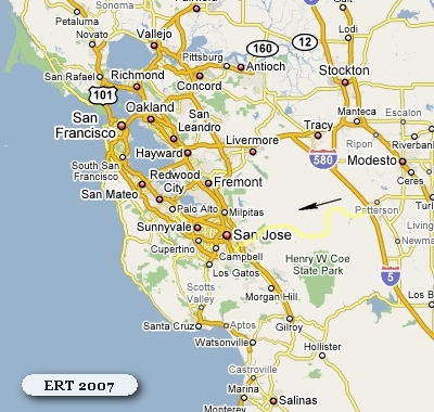
The above maps gives a graphic view of the vast, relatively undeveloped areas near the Megalopolis of the Bay Area and Silicon Valley.
As one might expect there is always the pressure to develop these open areas. Indeed, there was one scheme to study the feasibility of a 4 lane road through these mountains to connect the Santa Clara and the Central Valley thereby opening up more land for housing and other development as well as facilitating traffic in the area.
Proposed freeway
Money had been set aside by the state to study the feasibility of turning part of SR 130's legislative route from San Antonio Valley Rd east to Interstate 5 into a freeway. The road was intended to facilitate traffic between the Santa Clara Valley and the Central Valley, the latter is experiencing population growth and real estate development. The project's main proponent was former United States Representative Richard Pombo, who was the House Resources Committee chair when in Congress and himself a member of a family with extensive Central Valley property holdings near the proposed freeway's path.The proposed freeway's path west of San Antonio Valley Road would have bypassed Mt. Hamilton either to the north toward State Route 237 or to the south toward the San Jose's Evergreen district. The feasibility of the project had come into question, however, as crossing a freeway over the Diablo range near three of its highest peaks (Mt. Hamilton included) would have been very difficult. The project also faced stiff opposition from taxpayers, environmentalists, residents of the area looking to preserve their area's local charm and from the Lick Observatory. (A freeway through the mountains near the observatory would render it useless due to light pollution.) The freeway plan has been quietly abandoned after Congressman Pombo failed in his reelection bid in 2006.
Source: WikiPedia
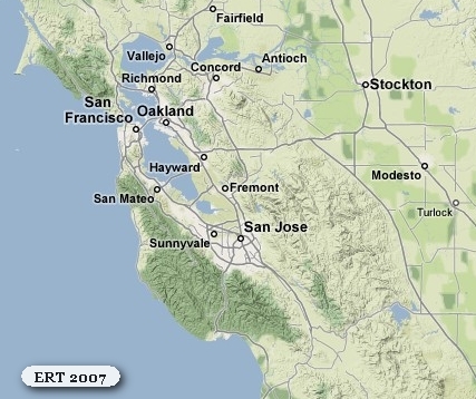
This map shows a more detailed route over the mountains.
Shortly after I left the Patterson area and started winding up the canyon on Del Puerto Canyon Rd (SR 130) I got as far as Frank Raines Park when it started to rain.
By the time I had reached the Stanislaus/Santa Clara county lines, it was pouring with no signs of letting up.
I continued on through the Upper San Antonio Valley and the nearby Hindu retreat of Shanti Ashram.
I wound my way up towards Copernicus Peak and Mountain Hamilton towards the Lick Observatory.
With every switchback up the mountain I could look east and down on the mountain road which I had driven. The rain and mist obscured what would have been magnificent, panoramic vistas of the mountains and distant valley. But, no such vies on this day. It will have to wait for another ERT.
I eventually reached the summit of Mount Hamilton and Lick Observatory. I had no idea the Observatory was even here and i had never heard of it before. It is an extensive facility and has its own police and a post office, and until recently a one-room schoolhouse.
Lick Observatory was the world's first permanently occupied mountain-top observatory.
The observatory was constructed between 1876 and 1887, from a bequest from James Lick. In 1887 Lick's body was buried under the future site of the telescope, with a brass tablet bearing the inscription, "Here lies the body of James Lick."
James Lick (August 25, 1796 – October 1, 1876) was an American carpenter, piano builder, land baron, and patron of the sciences. At the time of his death, he was the wealthiest man in California, and left the majority of his estate to social and scientific causes.
Source: WikiPedia
I crested the summit, starting the slow decent down and into the first of the 365 turns which make it possible to maintain a grade below 6.5%. Quite a feat of road building.
Still pouring the rain, I made my way carefully around each switch back. As I rounded one corner I caught a glimpse of something oddly familiar looking out of the corner of my eye. I hastily pulled over, nearly ditching the car in the process. I ran back to the tree I was and was delighted to find this:

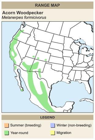
It is an Oak tree which and Acorn Woodpecker was using to cache food.
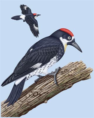

While I was taking this picture (in the pouring) I caught a glimpse of the bird in and adjacent tree and heard it's excited "squeaking" as it moved about on the trunk of the nearby Oak tree. Way cool. New bird for me and one I have always wanted to see. Especially the acorn cache. I had seen many pictures but never a real one.

If time and weather had allowed it would have been fun to count how many acorns were in this one tree.
That was my last intentional stop until I got to Milpitas. I say "intentional" because by the time I wound my way down the mountain and through the foot hills and fields to the valley and found my way up to I-680 on the east side of San Jose it was 4:40 on a Friday and as soon as I got on the Interstate it was grid lock. It took me nearly and hour to drive the 6 miles to the Milpitas exit. Thanks god I was not going any further.
I arrived at the Atkinson about 5:30. Erin answered the door and I was glad to see her smiling face. Safe at home, I was - after quite a long and interesting day.
Steve had not made it home yet as he himself was stuck in traffic. God - what a mess. The more that's get built, the worse it gets.
We spent a quiet and leisurely evening dining on Mexican take-out and talking about my trip.
The next morning we all had a nice breakfast together. Steve and I talked GeekSpeak most of the morning and then I packed up and was on the road back to the bay area around 11:00.
Up next - my last weekend in San Francisco.