From 30 to 62: Senior Citizenry
Day 1: 21 June 2012
Having just reached the joint milestone of 30 years of marriage, Betsy has just reached her own personal milestone: she is now officially a Senior Citizen. Yes, it is true - I married an older woman. Still a youthful 50 something, I now find myself married to a woman in her 60s. How did this happen!!??
Lots of people have asked that - how did someone like me end up with someone like Betsy? The only reason I can come up with is I got very lucky.
So, how to celebrate her 62 years on planet earth and entry into the ranks of Senior Citizens? Originally we had planned to spend 4 days in Baltimore at the condo which was graciously offered to us by Joan and Phil.
Our lodging secured, I set about the task of planning the trip. I got in touch with Tom and Becky who put me in touch with their daughter Claire. Claire had lived in Baltimore for several years and having met her I knew she was the kind of person who would have all kinds of groovy suggestions for fun things to do. I was not wrong. Here is an excerpt from an email she sent us:
Baltimore is a fantastic place to visit! If you are going in June it will be very hot, at least in downtown. Be sure to dress accordingly and carry some water. If you are driving into downtown there are some pay parking garages near/at the inner harbor, then you can walk to most places easily. Light Rail (above ground subway) is rather useless, as it only goes to a few places.
Here are a list of the museums and attractions that I really enjoyed:
- Baltimore Inner Harbor (cool to just walk around, places to eat, etc.)
- Baltimore National Aquarium
- Baltimore Conservatory
- National Museum of Dentistry
- Baltimore Museum of Art - (FREE ADMISSION!Really awesome.)
- American Visionary Art Museum
- Maryland Science Center
Some outdoor places that I really enjoyed were:
- Gwynns Falls Trails - (hiking and biking)
- Washington & Baltimore Rail Trails
- Gunpowder Falls State Park - (30 mins outside of the city. kayaking, etc.)
Please let me know if you have any other questions. I'd be happy to tell you more specifics!
WOW! With all of Claire's great suggestions, we knew we would have a blast. But, one of the first things Claire says above is "If you are going in June it will be very hot...". Fair warning!
Well, the week before we were to head over to Baltimore the weather forecast certainly mirrored Claire's warning. The temps were predicted to be in the 90s and above. And the humidity...? OUCH!
And, although we could avoid the heat by checking out the museums I really wanted our first visit to Baltimore to be exploratory and out-of-doors. Considering that, I reluctantly contacted Joan and Phil and told them we wanted to reschedule when the weather was cooler. They felt I had made the right decision to cancel and it was indeed. The day we were to arrive in Baltimore the temp soared to 101 degrees and the next couple of days followed with more sweltering heat, humidity and thunderstorms.
After making that decision we started planning from scratch. Since the heat was predicted to be widespread we decided to head for the mountains of western Maryland. Why there? The GAP!
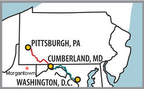
Map Source: Allegheny Trail Alliance
The map above shows the route of the Great Allegheny Passage (GAP). The red line segment represents the 141 miles of combined Rail-Trails. The blue line represents the 184 miles of the C&O Canal Towpath. Together they create a contiguous 325 mile trail from Pittsburg to Washington DC.
Betsy and I have both been on various sections of the Great Allegheny Passage, all of which were on the rail-trail segments, not the C&O Towpath. The latter is not the groomed trail surface we are used to so we decided to stick with what we knew.
After some discussion we decided 32 mile out and back day trips would be do-able. Being familiar with the sections from Frostburg MD to Meyersdale PA and Frostburg to Cumberland MD, we decided to make Frostburg our home base and make our out and back trips from there.

A closer look at Frostburg and our destinations for Thursday's and Friday's bike rides. The green line is the GAP.

The above map is one from a set available on the Allegheny Trail Alliance web site.
Click on the photos below for a larger image.

We arrived in Frostburg around 10am on Thursday. Betsy had chosen the Trail Inn as our home base.

While Betsy checked in, I looked around the place. They have accommodations for just about every type of stay as well as a cafe. The above sign was on the wall near the office. I could not find the "beer cave" so we just used our cooler.

Check in taken care of, we drove down to the trail-head and saddled up.
The stone path in the foreground is part of the switchback which climbs the hill back up to the
Western Maryland Scenic Railroad Depot and Trail Inn. Being light weights we decided not to use it.

Not bad for two days shy of 62 years old!
Today we would be riding to Myersdale, PA which is westwards towards Pittsburgh.

It was a cool morning and this made the climb up to Borden Tunnel, the first of the two tunnels, more pleasant.
The cyclist shown here was part of a group of Boy Scouts from the Youngstown, Ohio area.
The troop has 16 members and 12 went on the ride from McKeesport to Cumberland and back. Note the kitty litter containers used for panniers. Each rider had to make his own set including a chopped version used as a handlebar bag. Ingenious!
The age spread including leaders was from 10 to 70.
This is the east portal of the 957' long Borden Tunnel. It is about 2.5 miles west of Frostburg, our starting point.
The Borden Tunnel most likely takes its name from the Borden Mining Company. This New York based company, under the direction of its president, Colonel William Borden, undertook vast coal mining operations in the region from the late Nineteenth Century onward and became well known for its “celebrated” Cumberland coal. Construction had begun in 1910 on the Western Maryland Railway’s Connellsville extension.
The 86 mile line, which ran from Cumberland, Maryland to Connellsville, Pennsylvania, was completed in 1912. The extension gave the Western Maryland the shortest route from Baltimore to Pittsburgh and the lowest grade over the Allegheny Mountains. More importantly it connected the Western Maryland with the Pittsburgh and Lake Erie Railway and the New York Central system.
The Borden Tunnel is the last tunnel in Maryland before entering Pennsylvania. It was constructed in 1911 and is 957 feet long. It was built as a double track system and was also used to haul out local coal and clay.

Here, Betsy exits the west portal of the Borden Tunnel.

A little bit further down the trail and about 6 miles west of Frostburg we came across this work crew. It took us a minute to figure out what they were doing. The masonry strip represents the Mason-Dixon line. Cool idea and one of the reasons this trail is so interesting and so popular.
The Mason–Dixon Line (or Mason and Dixon's Line) was surveyed between 1763 and 1767 by Charles Mason and Jeremiah Dixon in the resolution of a border dispute between British colonies in Colonial America. It is a demarcation line among four U.S. states, forming part of the borders of Pennsylvania, Maryland, Delaware, and West Virginia (then, part of Virginia).
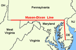
In popular usage, especially since the Missouri Compromise of 1820 (apparently the first official use of the term "Mason's and Dixon's Line"), the Mason–Dixon Line symbolizes a cultural boundary between the Northeastern United States and the Southern United States (Dixie) and legality of slavery as a result, although the Missouri Compromise Line had a much more definitive geographic connection to slavery in the United States leading up to the Civil War.
Source: WikiPedia
Just about a mile west of the Mason-Dixon line is tunnel number two, Big Savage Tunnel. It goes through Big Savage Mountain which is the grade we had been peddling up.
Savage Mountain is an anticline extending from Bedford County, Pennsylvania southwest into Western Maryland.[3] It is the western side of the Ridge-and-Valley Appalachians, and the eastern portion of the ridge forms the border of Garrett and Allegheny Counties of Maryland. The anti-cline includes two component ridges in Maryland, Little Savage Mountain and Big Savage Mountain.
Portions of Savage Mountain form the Eastern Continental Divide, separating watersheds draining to the Ohio River and those draining to the Potomac. To the northwest of Savage Mountain, waters drain to the Casselman River. The North Branch Potomac River watershed encompasses the southwestern and eastern portions of the ridge.
Source: WikiPedia

Just around the bend is the Big Savage Tunnel.

This is the view toward Cumberland at the rest stop just before the Big Savage Tunnel. It was a very hazy day but the view was still impressive.
The plant in the foreground is Viper's Bugloss (Echium vulgare). The name Bugloss, which is of Greek origin, signifies an Ox's Tongue, and was applied to it from the roughness and shape of the leaves.
It was introduced from Europe and now is found throughout the U.S.

The Big Savage Tunnel restoration cost millions!
In early 2001, estimates for rehabilitating the Big Savage Tunnel were just under $8 million.Both ends had collapsed from 25-plus years of neglect in the harsh environment of some of Pennsylvania’s highest parts. Ground seepage had broken through the old railroad liner, and waste-deep water filled the tunnel. As contractors found new problems, costs grew, imperiling the project. But two years later at a cost of more than $12 million, the Big Savage Tunnel was completed.
Source: Pittsburgh Quarterly
Note the doors. They are closed from November to April to help control freeze damage to the tunnel. The lights make it a breeze to ride through. And a breeze there was! The low temperature on the inside of the tunnel plus the breeze moving though it had both Betsy and I shivering by the time we exited.

This and the shot below are of the west portal of the 3,294' long Big Savage Tunnel

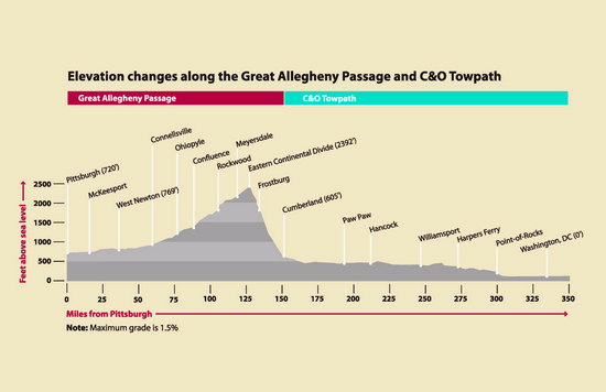
The elevation 2,392' makes the Big Savage Tunnel the highest point on the Great Allegheny Passage.
From here we drop about 380 feet in elevation to Meyersdale, our turn around point.

During our travels we have crossed all of the water divides in the US. But, this is the only one we have bicycled across! These beautiful murals were not there the last time I rode this section. There are murals on the west side as well.
On the west side of the divide the water drains to the Gulf of Mexico while the east side drains into the
Atlantic Ocean.
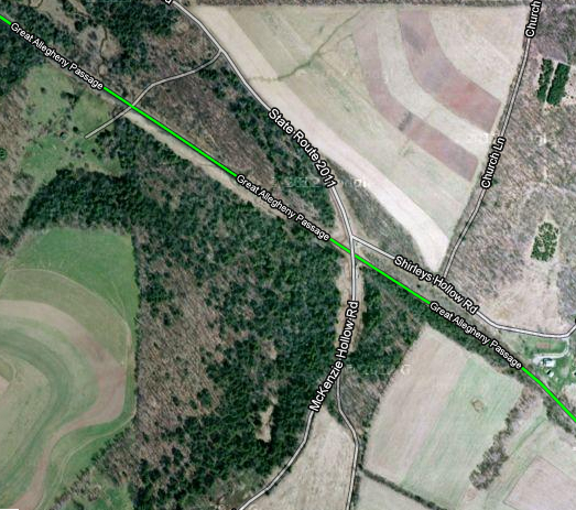
The short tunnel shown above is under McKenzie Hollow Road. It is often used as a rest stop and to escape from the sun on hot days.
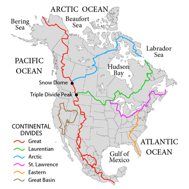
A continental divide is a drainage divide on a continent such that the drainage basin on one side of the divide feeds into one ocean or sea, and the basin on the other side either feeds into a different ocean or sea, or else is endorheic, not connected to the open sea. The endpoints where a continental divide meets the coast are not always definite, because the exact border between adjacent bodies of water is usually not clearly defined. The International Hydrographic Organization's publication Limits of Oceans and Seas defines exact boundaries of oceans, but it is not universally recognized. Where a continental divide meets an endorheic basin, such as the Great Divide Basin of Wyoming, the continental divide splits and encircles the basin.
Source: WikiPedia
On the wall inside of this tunnel there is a mural which represents an elevation profile of the trail. Below is a graphic of that elevation profile from the Allegheny Trail Alliance web site.

This is looking east from inside the tunnel under McKenzie Hollow Road.
About 7 more miles of peddling and we were at the depot in Meyersdale. We continued on for about another mile to the famous Salisbury Viaduct.

This is the west side of the viaduct looking back towards Meyersdale. This amazing structure, which is actually a nearly 2000' foot long rail-road trestle, crossed the valley through which the Casselman River and US Rt 219 run.
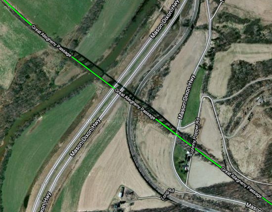
In the Google maps image above you can see the shadow of the steel structure which supports the deck of the trail.
A viaduct is a bridge composed of several small spans. The term viaduct is derived from the Latin via for road and ducere to lead something. However, the ancient Romans did not use that term per se; it is a modern derivation from an analogy with aqueduct.[citation needed] Like the Roman aqueducts, many early viaducts comprised a series of arches of roughly equal length. Viaducts may span land or water or both.
Source: WikiPedia
At this point we did an about face and headed back to the
Meyersdale Depot. The depot sits on a hill above downtown Meyersdale.
While Betsy chilled and checked out the depot I coasted down to the Subway, had a bite to eat and then peddled back up the hill.
Just as I got to the still very active RR tracks the barriers came down and a train chugged up the grade in front of me. It was using 4 engines and had who knows how many cars. I waited for about 10 minutes for the train to pass and then completed the climb back up to the depot.
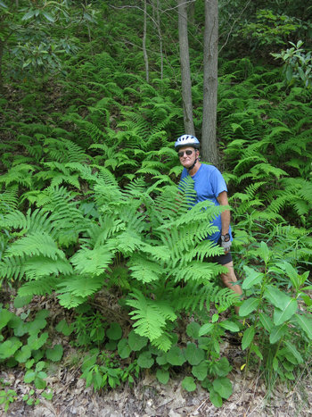
On our way back to Frostburg we went through a nice shady section of trail where there were many lovely ferns. Here we see Interrupted Fern (Osmunda claytoniana) (foreground) and Hayscented Fern (Dennstaedtia punctilobula).
That is the last photo from day one of our biking adventure - the ride from Frostburg to Myersdale and back via the Great Allegheny Passage.
We got back to the Trail Inn around 4:00, had a cool beverage on the porch, cleaned up and had supper at the Trail Inn Cafe. They were having a special on Broasted Chicken dinners - two for the price of one. Groovy! We got the 3 piece meals, two dinners for seven bucks. Sides to choose two from were cole slaw, baked beans, fries, applesauce, mashed potatoes and potato wedges. Plenty of food. I ate all three pieces of my chicken. Betsy ate two and we saved the last piece to have for lunch on our ride the next day.
From 30 to 62: Senior Citizenry
Day 2: 22 June 2012
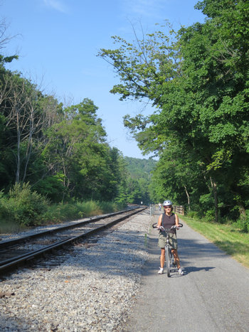
Friday morning was a bit warmer and certainly more humid. Today we would bike the section of rail-trail from Frostburg to Cumberland.
The terrain map at the beginning of this report shows the elevation of Frostburg as 2,070' and Cumberland as 627'. That is an elevation drop of 1443'. This means it is pretty much a coast all the way down the mountain. But, of course, what goes down must come up - at least in this instance.
Although I snapped no shots, we saw about 100 cyclists climbing the grade from Cumberland to Frostburg. This group was part of the Rails-to-Trails Conservancy's 2012 Greenway Sojourn.
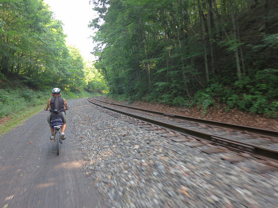
As you can see, this section of the GAP is the Rail-with-Trail. The "rail" part is The Western Maryland Scenic Railroad which is a 501(c)(3) non-profit organization. Were it a commercial rail line, it is unlikely the trail would be there. And, if it were it would probably be separated from the RR track by an 8' foot high fence topped with razor wire similar to the one we saw on the Illinois Prairie Path. At mile markers 5 and 9 the Metra railroad tracks parallel the trail on its north side in Glen Ellyn and Wheaton. The fence is quite ugly.
The Western Maryland Scenic Railroad (WMSR) is a heritage railroad based in Cumberland, Maryland. It operates over ex-Western Maryland Railway (WM) trackage to Frostburg, Maryland and back using both steam and diesel locomotives.
The WMSR operates passenger excursion trains out of the former Western Maryland station in Cumberland, which also houses one of the six visitor centers of the Chesapeake and Ohio Canal National Historical Park as well as other attractions and offices. This station was built in 1913.
The railroad offers coach and first class service, as well as reserved caboose rides. The railroad also runs murder mystery excursions and special seasonal trips.
Source: WikiPedia
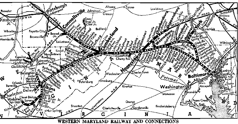
Check out all the stops!
Now it is all cars and trucks and an ever dwindling supply of fuel.
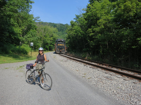
And, here is the engine for the Western Maryland Scenic Railroad. We saw it on the way back as well.
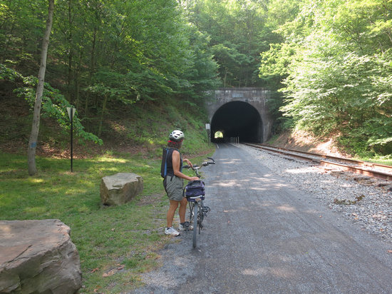
Tunnels are always fun to cycle or walk through and this one gave us some much needed coolness and shade both coming and going.
The Brush Tunnel is a 914-foot railroad tunnel located about 1 mile (1.6 km) west of Corriganville, Maryland.
It was built in 1911 by the Western Maryland Railway, and is currently used by the Western Maryland Scenic Railroad, a tourist railroad running between Frostburg and Cumberland, Maryland, as well as the Allegheny Highlands Trail of Maryland (part of the Great Allegheny Passage rail trail). Some had expressed concern regarding the dual use of the tunnel, but time has shown that the scenic railroad and the bicycle trail can peacefully co-exist.
The Allegheny Highlands Trail of Maryland is currently complete from Cumberland to near Pittsburgh, Pennsylvania, using mostly abandoned rail right-of-way. The portion of the trail from Cumberland to near Frostburg trail is adjacent to the active tourist line, including the tunnel.
As the tunnel was bored for two tracks, and the scenic railroad uses only one, there is sufficient room for the bicycle trail alongside in the tunnel, which is now lighted. (However, trail users are cautioned not to be in the tunnel when a train is in or approaching the tunnel.)
Source: WikiPedia
There is an interpretive sign for this and other interesting features along the trail. Here is the text from the sign:
Brush Tunnel - The Brush Tunnel was built in 1911, constructed of reinforced concrete, and designed for two tracks. The tunnel is located on the Connellsville Extension of the Western Maryland Railway in Cash Valley, four miles west of Cumberland. The extension from Cumberland to Connellsville, Pennsylvania was completed in 1912 at an enormous cost through rugged and mountainous country.
The line was built to serve a twofold purpose; to provide a western outlet for the Western Maryland and an eastern tidewater outlet for the Pittsburgh and Lake Erie Railroad. It afforded the Western Maryland the shortest line between Baltimore and Pittsburgh and the lowest grade line across the Allegheny Mountains. These 1915 photographs include a Baltimore to Chicago passenger train entering the tunnel, soon to emerge into the Jennings Run Valley.
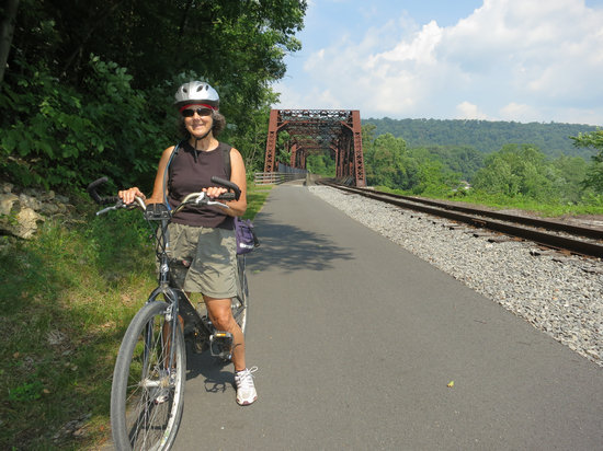
At this point we have only a few miles to go before we get into Cumberland proper.
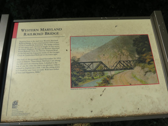
Here is the text from the interpretive sign:
Western Maryland Railroad Bridge - Depicted here is the steel truss Western Maryland Railway Bridge. It was constructed in 1910 as part of the Connellsville Extension. The bridge consists of two spans, each 150 feet in length. It now serves the Great Allegheny Passage and the Western Maryland Scenic Railroad. Note the Historic National Road on the left and the long-gone tracks of the Georges Creek & Cumberland Railroad on the lower right.
The back of this postcard, dated November 24, 1912, reads as follows,
“Dear Friend, Well here I am among the hills and I am enjoying them. I climbed to the top of one the other day and it was glorious. Only it seemed to frighten me a little. I felt like sitting down so I would be sure I was on earth. With best wishes of love and happiness, Millie.”
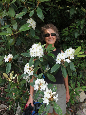
Here, Betsy competes with the beauty of these Rhododendron flowers.

These trusses were larger than I am used to seeing on the "Great Laurel" (Rhododendron maximum).
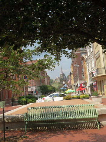
This is the view from our lunch at the pedestrian mall in downtown Cumberland.
Every time we have the opportunity to enjoy a place like this it makes me wish we could do something similar in my home town of Morgantown. HA! Fat chance...
The Downtown Cumberland Historic District, also referred to as the Downtown Cumberland Mall, is the main shopping and dining district for the city of Cumberland, Maryland.
The district is located in the heart of the downtown area along Baltimore Street, formerly the main thoroughfare through the city. Baltimore Street is now a brick pedestrian mall. The street is lined with large multistory commercial buildings, most of which were built in the late 19th and early 20th centuries. These buildings, which were formerly banks, hotels, and department stores, are relics of the city's former wealth and importance during the industrial age.
They now contain tourist oriented businesses such as sidewalk cafes, antique stores, boutiques and art galleries. Baltimore Street hosts some of the city’s biggest sidewalk festivals and block parties. In the warmer months the weekly Farmers Market will draw hundreds downtown and often evenings there will be activities such as outdoor dining with live music or block parties.
Source: WikiPedia
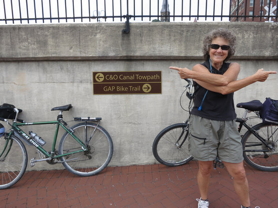
After finishing up our lunch of leftover Broasted chicken and other goodies we peddled on over to the Western Maryland Station at Canal Place. This is where the Rail-trail ends and C&O Towpath trail starts. Together, these two trails make up the 325 miles of the Great Allegheny Passage (GAP).
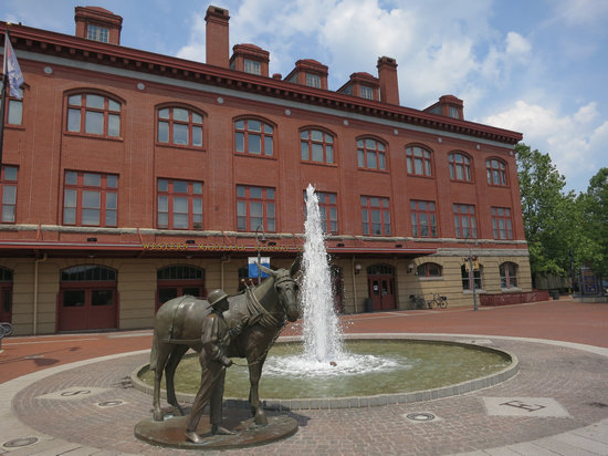
This is the back side of the restored train depot. This sculpture gives tribute to the men and mules which made the Towpath work.
From here we made our way back to the trail and started the slow, steady climb back to Frostburg - all 1443' of it!
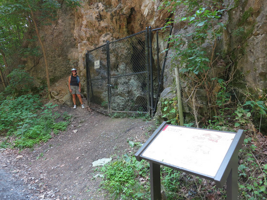
On our way down the mountain we passed this entrance to Cumberland Bone Cave. If you look carefully you can see some plants of Purple Cliffbrake fern (Pellaea atropurpurea) which most often grows on limestone or some type of calcareous substrate.
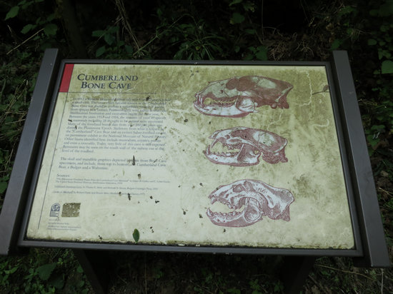
Here is the text from the interpretive sign:
In 1912 a Western Maryland Railway cut near the town of Corriganville exposed a small cave. The cave, which became known as the Cumberland Bone Cave, was found to contain a remarkable variety of bones from species now extinct. Paleontologists were called in from the Smithsonian Institution and excavation began that same year. Between the years 1912 and 1916, the remains of over 40 species of mammals including 28 thought to be extinct were recovered.
Many of the fossilized bones date from over 200,000 years ago. Skeletons of the Pleistocene Cave Bear and an extinct Saber-toothed cat are on permanent exhibit at the National Museum of Natural History. Today, very little of this cave is still exposed. Remnants may be seen on the south wall of the railway cut at the level of the roadbed.
Shortly after we passed Bone Cave the effort to peddle up the grade seemed considerable. I then saw why - my front tire was nearly flat.
I now remembered the last time I inflated the tube, the valve broke. So, there was no pumping up this tire, it would have to be changed out. The spare tube I was carrying was already patched and I more or less just kept my fingers crossed for the next 10 miles hoping the patch would hold. It did.
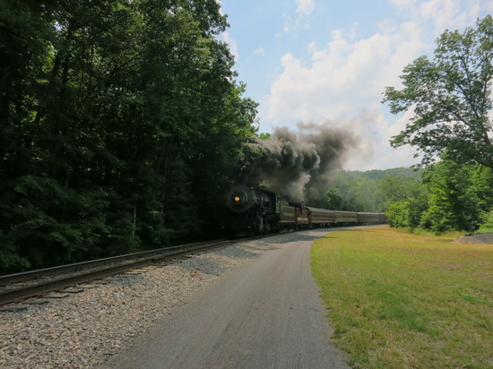
Here comes the train chuggin' down the mountain. This clearly shows the amount of smoke, soot and steam these old engines spewed out.
We continued on up the grade. The temps rose along with the humidity. It was pretty oppressive. When we got back to the Trail Inn we cracked open a couple of cold ones and sat on the porch. The sky darkened and in short order there were gusty winds and a torrential down pour. We had made it back just in the nick of time.
We cleaned up, rested and relaxed and then set out in search of some dinner. We decided to drive down the rode which went past the Inn and see where it went and where it led us.
About 4 miles down the road we passed through the small town of
Mt Savage. This place looked interesting. There were numerous old buildings and a place called "The Castle". We will definitely have to go back and explore this place some day.
The Mount Savage Castle located in Mount Savage, Maryland was built in 1840 as a plain stone house by the Union Mining Company. Before the turn of the 20th century, the house was purchased by Andre Ramsey, an immigrant from Scotland who extensively modified the house and converted it into a replica of Craig Castle near his home in Scotland. In 1984, the castle was renovated for use as a bed and breakfast facility.
Source: WikiPedia
As I suspected, the road (MD-36 S/Mt Savage Rd NW) eventually took us to
Cumberland where we parked at the Depot and walked to the
Pedestrian Mall where we had eaten our lunch earlier that day.
As we walked down the street we heard music in the distance.

The band "Black Diamond" was playing as part of the"Friday After Five concert series.".
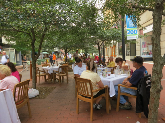
City Lights Grill was adjacent to the square so we grabbed an outdoor table. It was a wonderfully breezy and warm evening and we had a front row seat for the band.
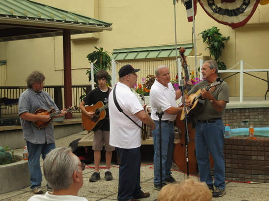
The youngster on the guitar is the grandson of the guitarist on the right. The grandson was proudly introduced by grand paw and featured on one of the tunes they played.
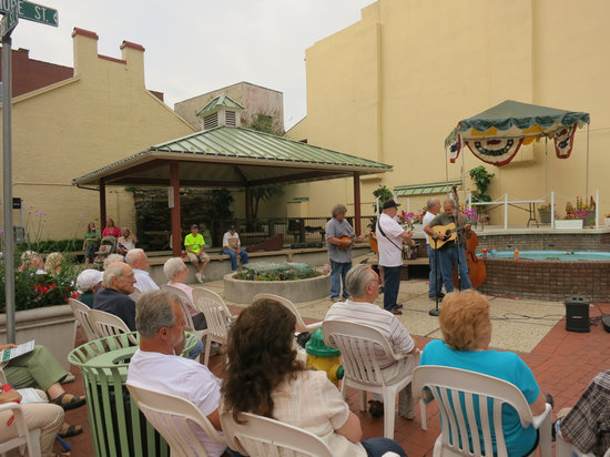
Cumberland has done a great job making their downtown area a place where people can come and relax, stroll , listen to music and have a bite to eat.

Speaking of eating! Betsy had the salmon and I had spaghetti with red sauce.
I can't speak to Betsy's meal but my spaghetti portion was small and sauce was thin and overly sweetened. And, at 10 buck this meal is definitely a two thumbs down.

As we walked back to the car I snapped this photo of the old Embassy Theatre. "The Family Theatre with Popular Prices".
The historic Embassy Theatre opened its doors to the public on November 18, 1931. Another splendid ‘sister’ movie palace with the same name began business that night in New York City on 48th Street and 7th Avenue, a strictly black tie and gown affair with klieg lights and all the glamour accorded to a Hollywood opening in both locations. Two auspicious new Embassy Theatres, each with a glittering neon marquee, hoped to attract patrons.
Source: New Embassy Theater
Then, it was back to the Trail Inn via the Scenic Route through Mt Savage.
The next day we drove home via the Laurel Highlands. It was now June 23rd - Betsy's 62nd birthday and she was officially inducted in the ranks of the Senior Citizens. Bye, bye...
'Till next time...