Sunday, October 14
After my lunch at Thanh Thanh Cafe I wandered back up to Geary Street via a circuitous route.
Click on these photos for a higher resolution.
They will be slow to load with a dial-up connection.

I guess it seems odd to photograph garbage, but it is not oftem I see empty boxes which contained "dried curd".

Perhaps this is part of the solution to individual car owership.
Zipcar offers a new model for automobile transportation.
Past
In the fall of 1999, our two Zipcar founders were sitting in a café, excited about a concept they had seen in Berlin while on vacation. Cars were parked around the city for members to drive by the hour instead of owning their own vehicles. They had a Eureka! moment (or maybe it was more like, "Duh! What an obvious idea.") They put an American spin on it - outfitting the cars with wireless technology, creating a hassle-free reservation system and strategically placing the cars around key cities and neighborhoods. In June of 2000 the first Zipcars were on the road. The masses could now drive cars by the hour or day - on their terms.Source: ABout ZipCar

I passed by this bakery while on my way back to the car and could not resist a peek inside.
For years the Richmond was a mix of Irish, German, and Jewish families. In the 1950s the shift to a Chinese population began that continues today. While there had been a "White Russian" community in the district for over sixty years, in the 1990s the Russian community swelled with the collapse of the Soviet Union. Few areas in the city are as integrated with varied and strong cultures.
Source: Outsidelands.org

The inside of the bakery was chock full with goodies of every description - and color!


I was very tempted to get one of the poppy seed rolls ( bottom, center) but I knew I would have to leave it behind or try to get it back in one peice on the plane home. DRAT!


I was glad I did not find this place during my first week in San Fran - I would have put on some tonnage!

It says "Russian Bread: Chebureki (black bread), khachapuri (Georgian cheesebread), cookies, sweets, savories, dumplings, poppy-seed rolls, and many others".
Next time I get back to the City this bakery will be one of my first stops.

I poked my head into a nearby church and snapped this. I have no notes, but I think it was the Russian Holy Virgin Cathedral of The Church In Exile.
A brief history of Russians in San Franscico may be read here.

Back in the car and over to Lands End to use the facilities.
Lands End is San Francisco’s wildest and rockiest coast, a place strewn with shipwrecks and rife with landslides. These wave- and wind-carved headlands west of the Golden Gate connect two popular landmarks: the Cliff House and the Palace of the Legion of Honor.
The Spanish named Lands End’s westernmost promontory Point Lobos, so-called for the many lobos marinos (sea wolves, or sea lions as they’re known today) that once hauled up on the rocks offshore. The rocks are now roosts for two dark bird species, cormorants and oystercatchers, among others. Trails at Lands End offer a cliff-top walk through shadowy cypress, with scenic overlooks, 30-mile views of the coast, and foot access to several shoreline pocket beaches.

Guess you can use the bathrooms but you can't spend the night. Great for day sleepers!

"Brush sculptures"? "Forest health pruning"? Where the hell am I - California??!!

As I mosied down the trail I noticed a crowd up in the trees. Turns out it was a confidence and team building outing for one of the local schools.


Not far from where I parked was this battle damaged flag bridge from USS San Francisco.

The USS San Francisco served in the strategically critical Battle of Guadalcanal in World War II. The ship was severely damaged in that battle, and was brought back to San Francisco for repairs.
The center piece of this memorial is the damaged flag bridge of the USS San Francisco -- a section of which is pictured here. The next photo in this gallery shows the location of the damage on an illustration of the ship.
In her career, the The USS San Francisco earned 17 battle stars. After the war, this memorial was erected by San Franciscans to commemorate her service and the men who were lost in the war.
Source: About.com
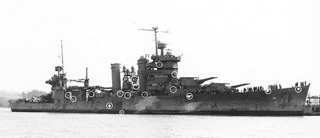
USS San Francisco off Mare Island, Dec. 1942 showing location of enemy shell hits.


There are more photos at the USS San Francisco Memorial Foundation.

Major pruning of these Monterey Cypress Callitropsis macrocarpa shows the twisted and contorted trunks. This "daylighting" no doubt discourages the homeless from sleeping here as well.

More groovy steps being constructed. My visits to the Coastal Trail really helped revivie me after being worn out and worn down by the constant hustle and bustle of the city.
What is the wildest place in San Francisco? While some might argue for the South of Market nightclubs or the new wave industries of Media Gulch, I vote for the Land’s End Coastal Trail. It’s hard to believe you can find a city trail that feels this natural and remote, featuring million-dollar views of crashing surf, offshore outcrops, the Golden Gate Bridge, and the Marin Headlands. But here it is.
The trail begins near Ocean Beach and winds its way north and east along the ocean bluffs to China and Baker beaches. In its entirety, Coastal Trail is 11 miles long, although it’s not contiguous. My favorite stretch is a 3.5-mile round-trip that follows the most “wilderness-like” section from above the Cliff House Restaurant to 32nd Avenue and El Camino del Mar. At least for a while, you’ll forget you’re anywhere near a major metropolitan area.

One of many great views along the Coastal Trail.

Yet another legume I could not identify.

Wild fennell, yet another invasive which is very common.

Excellent signage help people like me who are spacially challenged.

More views of the San Francisco bay.


And still more groovy steps. The design, placement and installation of all these stairways is top-notch.

This shows stump sprouting on a cut Eucalyptus.
This tree, know commonly as Blue Gum Eucalyptus globulus was extensively planted in coastal Californian and there are large groves with big trees throughout the area.
I came accross this facinating history of the Bluegum.Introduced to San Francisco in 1853 from Australia at a time when transpacific shipping was booming because of big gold discoveries, the Tasmanian blue gum soon attracted attention because of its rapid growth. By 1860 substantial 50-foot trees, originally planted as ornamentals, attested to the astonishing ability of this plant to create wood in a hurry.
By the 1870s planting was under way for fuel, windbreaks, and shade. California Senator Ellwood Cooper published Forest Culture and Eucalyptus Trees (Cubery & Co., San Francisco, 1876), giving an enthusiastic report of his experimental plantings near Santa Barbara, with details of planting, harvesting, and costs and sales.
Cooper visited Tasmania and saw the giant trees in their native habitat; his book reports two fallen specimens of E. amygdalina with measured heights of 460 and 512 feet respectively. (No living tree is known today that tops the tallest living Sequoia.) The fame of the virgin forests quickly spread around the world. A single plank 75 feet long and 10 feet wide was shipped to the London Exhibition of 1862 (and later returned). A 165-foot plank that was also to be sent could not find a shipper. In 2001 the tallest reported in the United Stares was 160 feet high and 38 feet in girth, growing in Petrolia, California.
Two thousand miles of blue gums have been planted in Southern California to protect citrus groves from cold winds. Many blue gum plantations in California have been returned to farm land, but survivors did prove to be salable on the stump, to Japan.
The logs are loaded onto special factory ships and arrive in Japan, value-added, reduced to chips and ready for manufacture into chemicals and paper. The technology for making paper from eucalypts was developed in Australia during World War II when outside supplies were cut off. A similar wood-chip trade exists from Tasmania, where Japan has invested in a port and railway into the interior for getting the blue gums, three-quarters of which have now been removed.
For economic reasons, old growth forest of other hardwoods is being logged, to be replaced by Monterey pine and other fast growing tree crops despite protest by the community. Balancing economics against environmental concern is precarious: the Green movement in Australia was effective in blocking the construction of a hydroelectric dam in the Tasmanian wilderness but the needed electricity is now generated by a coal-fired power station. In California commercial blue gum planting is now history, as ornamental planting has shifted attention to other eucalyptus species.