Sunday, October 14
Click on these photos for a higher resolution.
They will be slow to load with a dial-up connection.

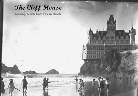
The Coastal Trail at Lands End follows the rail bed of the steam-powered Cliff House railroad, which was built by Adolph Sutro to lure people from downtown San Francisco out to the baths and the Cliff House. Although landslides forced the railroad to close in the 1920s, the rail bed itself is now part of the Coastal Trail, with dazzling views of the Pacific Ocean, the Golden Gate Bridge and the Marin Headlands.

This aerial photo of Lands End by Robert Campbell is from one of the interpretive signs. There are lots of spectacular shots at his website.

As I continued my stroll along the Coastal Trail I took in all the great views of the bay.

As the fog burned off and the day turned sunny and warm I encountered more people running, walking and taking in the scenery.

Looking north towards Sea Cliff and the tiny China Beach.

One of California's most common ferns - the Sword Fern Polystichum munitum. It i in the same genus as our common Christmas Fern Polystichum acrostichoides here in West Virginia.

This area maps give one a good idea of the extent of the Coastal Trail - from Ocean Beach to the Golden Gate Bridge where it then connects whith the Golden Gate Promenade.

You can use click the image for the high resolution version to read the sign.

This was shot from 32nd Avenue and El Camino del Mar. I do not know if there is anyway to get to Baker Beach and continue on the trail except by sidewalks.

Here is a satellite image from Google of the area where the trail ends and streets begin. It shows the area of China/Baker Beach, the Presidio and Golden Gate Bridge.

This bench is just before you get to the end of the trail.
This is a satellite image from Google of the bench and observation platform. I am always amazed at the detail of some of the imagery which is on Google Maps.

I saw these little GoCars all over the tourist hot spots. They can be rented for:1st hour - $44, 2nd hour - $34, each additional hour - $24
What's a GoCar?
It's a tour guide…a talking car…a trusty co-pilot…and a local on wheels.
GoCar is the first-ever GPS-guided storytelling car - and it's available to rent right now!
Leave your guidebook behind and see the San Francisco, San Diego, and Miami most visitors never see. Hop into a GoCar and let this little yellow car take you on a guided tour of these fantastic cities.
Your clever talking car navigates and shows you the way – but that's not all. As you enjoy the drive, it takes you to all the best sites and tells the stories that bring these cities to life.
Source: GoCar

Personally, I can't imaging using one of these unless you had very limited time and wanted to cover a lot of ground in a few hours.

Another look at the steps leading up to the area near El Camino del Mar.

To me, this sign was like a personal invitation and down that little path I went. I found a nice private spot which looked unused and not often visited. It would be a cool place to spend the night - if you were not a sleep walker.

This interesting stairway leads to Mile Rock Beach.

The red arrow point to a post which supports the gnarled and dangling trunk of this Monterey Cypress.

Mile Rock Beach as seen from the overlook.

The labyrinth just below the point of the overlook.

The edge of the vista area is a sheer drop to the rocks below.


Another look at the labyrinth.

A most excellent vantage point.

Map from the San Francisco Chronicle.

I saw these flowers on the way back to the car. The common name is "Red Hot Poker".

As I made my way back towards the Cliff House I walked through extensive areas of newly planted natives. Part of the ongoing restoration project.

This should be glorious once all the plants have filled in.

Yet another GoCar.

All that remains of the once would famous Sutro Baths. The site of the original Cliff House is in the background.
The Western Neighborhoods Project has a wealth of info on not only the Baths, but the entire neighborhood.
The San Francisco Public Library has an interesting online exhibit about the Baths.

What was left of the Baths burned down in 1966.

The Ruins
Beyond the striking location and colorful history, it's especially remarkable for such a place to exist in a country where few structures past their best days survive.It's allowed to be harrowing and wild in a time and place where shampoos carry warnings and most interesting things are cordoned off for your protection. Here's the playground for those who love crumbling stone clubhouses, jutting pipe monkeybars, stairways that lead you off cliffs and shifting sandboxes that get swallowed by surf.
The GGNRA includes the Marin Headlands, Point Reyes National Seashore, Angel Island, Alcatraz, and other sensory feasts.
The Baths
Sutro Baths opened March 14, 1896 with a $1 million pricetag — an extravagant public bathhouse envisioned and developed by the eccentric one-time mayor of San Francisco, Adolph Sutro.Five hundred dressing rooms ... spacious elevators and broad staircases ... pavilions, balustrades, promenades, alcoves and corridors adorned with tropical plants, fountains, flowers, pictures, ... the collected treasure of foreign travels... a portico with four Ionic columns and pilasters which lead to a noble staircase, wide, gradual of ascent, bordered with broad-leaved palms, the flowering pomegranate, fragrant magnolias ... [touching] the very rim of the reveling waves.
After working its way through its many lives (Playland, 1960s ice rink, etc..)— burned down while being demolished on June 26, 1966. In 1980 the Golden Gate National Recreation Area (GGNRA) bought the land for $5,500,000.
The original stats of the fully-built Sutro Baths were:
- Length of baths, 499.5 feet.
- Width of baths, 254.1 feet.
- Amount of glass used, 100,000 superficial ft.
- Iron in roof columns, 600 tons.
- Lumber, 3,500,000 feet.
- Concrete, 270,000 cubic feet.
- Seating capacity amphitheater, 3,700.
- Seating capacity promenade, 3,700.
- Holding capacity, 25,000.
- Salt water tanks, 6.
- Capacity of tanks, 1,804,962 gallons.
- Fresh water, plunge tank, 1.
- Toboggan slides in baths, 7.
- Swinging rings, 30.
- Spring boards, 1.
- Private dressing rooms, 517.
- Club rooms capacity, 1,110.
- Time required to fill tank by waves. 1 hour.
- Time required to fill tank by pump, 5 hours.
Source: SutroBaths.com


Looking south to Ocean Beach from the site of the former Cliff House.

And now back to the city streets! After a my wonderful hike I was ready to head back to the apartment for a nap and some last minute packing.
On my way to gas up the rental car I spotted this stenciled on the side walk. It was no doubt inspired by the song from the movie "Team America: World Police".
Play the video to hear Kim Jong-il sing his heart out!

The gas station attendant. It would seem, regardless of the locale, some things never change.

After a nap I hopped on the 22 Fillmore bus to look for some dinner and ended up at here at Dino's Pizzeria on the corner of California and Fillmore Streets.

Ahh... good old spaghetti and meat balls!
It was only after I ordered this, my last meal in San Francisco, I realized I had also ordered the very same thing on my first day in the City.

This is the last shot I took on this the last day of my amazing 27 days in San Francisco and Central California.
Now, on this day, March 10th, 2008 the whole trip seems like a dream and it has already been 6 months since my return on October 15th. I have struggled mightily to finish up the web work on this ERT and as the old saying goes: "Better late, than never".
I hope you enjoyed looking at the photos and reading about my trip.
~FINIS~
<= Back to Part 2