Mississippi embayment
From Wikipedia, the free encyclopedia.
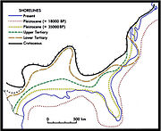
The Mississippi embayment is a physiographic feature in the south-central United States. It is essentially a northward continuation of the fluvial sediments of the Mississippi River Delta to its confluence with the Ohio River at Cairo, Illinois. The embayment is a topographically low-lying basin that is filled with Cretaceous to recent sediments. The northern end of the embayment appears as an anomalous break in regional geologic structure with Paleozoic sedimentary rocks both to the east in Kentucky and Tennessee and to the west in Missouri and Arkansas. The current sedimentary basin results from the filling of a Cretaceous tectonic basin and existed as a large bay in the Cretaceous through early Tertiary shoreline.
The New Madrid Seismic Zone lies at the northern end of the embayment. It was the site of the large New Madrid Earthquake of 1811 - 1812, arguably the most intense earthquake event in North American history. The area is underlain by some anomalous geology. The Reelfoot Rift is an ancient failed continental rift which dates back to the Precambrian break-up of the supercontinent Rodinia. The relatively more recent opening of the Atlantic Ocean and Gulf of Mexico during late Paleozoic to early Mesozoic break-up of Pangea no doubt affected and may have partially re-activated the old rift.
See also
- Crowley's Ridge
- Mississippi Delta — the subset of the embayment that lies in Mississippi state, noted for its distinct cultural history


