Seoul
From Wikipedia, the free encyclopedia.
| Seoul Metropolitan City | |
|---|---|

|
|
| Korean name | |
| Revised Romanization | Seoul Teukbyeolsi |
| McCune-Reischauer | Sŏul T'ŭkpyŏlsi |
| Hangul | 서울 특별시 |
| Hanja | none |
| Short name | Seoul (Sŏul; 서울) |
| Statistics | |
| Population | 9,747,972 (2005) Ranked 23rd (Metro area c. 21,000,000) |
| Area | 607 km² (approximate) |
| Government | Special City, Capital of South Korea |
| Administrative divisions | 25 wards (Gu) |
| Region | Sudogwon |
| Dialect | Seoul |
| Location map | |
 |
|
Seoul (서울, listen ▶(?)) is the capital of South Korea and is one of the most populous cities in the world, located in the northwestern part of the country on the Han River. It is a designated special city. On the establishment of South Korea (the Republic of Korea) in 1948 it became the capital of the country, except for a short time during the Korean War. Seoul is located at 37°35′ N 127°0′ E.
Seoul is located in the northwest of the country, south of the DMZ, on the Han River. The city is the political, cultural, social and economical centre of South Korea. It is also an international centre for business, finance, multinational corporations, and global organizations. This, along with its position as the capital of one of the world's largest economies, has continued to raise its global status. Today, it is one of the most visible symbols of the Korean economic Miracle of the Han River.
According to UN Population Division figures, Seoul's Urban Area contained 10.3 million people in 2003, making it the 22nd most populous such area in the world. This ranking can vary from different independent sources, where the metropolitan area surroundings and suburbs can make differences. Its density has allowed it to become one of the most digitally-wired cities in today's globally connected economy. It also has more than 1 million registered vehicles which cause widespread traffic-jams beyond midnight. The larger Seoul metropolitan area and commuter belt, which includes the major harbour city Incheon and the largely residential city of Seongnam, is one of the world's most heavily populated. In recent years, the metropolitan government has carried out an extensive cleanup of the city's heavy air and water pollution, transforming the previously murky atmosphere into a cleaner one, though air pollution is still problematic.
Contents |
Names
The city of Seoul was known as Hanyang (漢陽) during the Goryeo period. It was renamed Hanseong (漢城) when it became the capital of the Joseon Dynasty in 1394. It was renamed Gyeongseong 京城—Keijō in Japanese) during the Japanese Colonial Period, and finally given the name Seoul after the 1945 liberation. The word Seoul has been used to refer to a capital since the Silla period. The word originated from the archaic words of 'seobeol' or 'seorabeol'. Both were referred to Gyeongju, then capital of Silla, and meant the capital or capital city. The Hanja gyeong (京) also means "capital" and is used to represent Seoul in the names of railway lines and freeways, for example, the Gyeongbu (Seoul-Busan) railway line and the Gyeongin (Seoul-Incheon) freeway.
Chinese Adaptation of "Seoul"
Unlike most place names in Korea, "Seoul" has no corresponding Hanja, which are Chinese characters used in the Korean language. The word "seoul" in Korean means "capital city". For people who use the Chinese language, the city has been known instead as 漢城 (read as Hànchéng in Chinese, Hanseong in Korean), the Joseon Dynasty name of the city which denotes a fortified city (seong) on the Han River.
After months of discussion and debate, the Seoul Metropolitan Government officially announced on January 18, 2005 that the Chinese name of the city would officially be changed to 首爾 Shǒu'ěr, which is a close transliteration of Seoul, where 首 shǒu can also mean "first" or "capital". The new name will be used for all official government websites and publications in Chinese, instead of 漢城. The Seoul Metropolitan Government also asked the government of the People's Republic of China (PRC) to use this new name, and it was officially adopted by China nine months later, in October 2005. The government of the Republic of China (Taiwan) [1] also officially recognizes the change in the Chinese name as decided by the South Korean government.
History


See also: History of Seoul
The history of Seoul can be traced back as far as 18 BC. In that year the newly established kingdom of Baekje built its capital Wiryeseong in the Seoul area. There are several city wall remains in the area dating from this time, and Pungnap Toseong, an earthen wall just outside Seoul, is widely believed to be the main Wiryeseong site. During the time when the Three Kingdoms fought for hegemony in Korea, the Seoul area was often contested. Control passed from Baekje to Goguryeo in the fifth century, and from Goguryeo to Silla in the sixth.
It was thought that only the kingdom that controlled the Han River valley would be able to control the whole of the peninsula, because it was a centre of transportation. This was the reason why in the 11th century the ruler of the Goryeo Dynasty built a palace in Seoul, which was referred to as the "Southern Capital".
At the beginning of the Joseon Dynasty, the capital was moved to Seoul (also known as Hanyang and later as Hanseong), where it remained until the fall of the dynasty.
Originally, the city was entirely surrounded by a massive circular wall (a 20-foot-high circular stone fortress) to provide its citizens security from wild animals such as the tiger, thieves and attacks. The city has grown beyond those walls and although the wall no longer stands (except in the mountains north of the downtown area), the gates remain near the downtown district of Seoul, including most notably Sungnyemun (commonly known as Namdaemun) and Honginjimun (commonly known as Dongdaemun). During the Joseon dynasty, the gates were opened and closed each day, accompanied by the ringing of large bells.
During the Korean War, Seoul changed hands between the Chinese-backed North Korean forces and the UN-backed South Korean forces several times, leaving the city heavily damaged after the war. [2] One estimate of the extensive damage states that after the war, at least 191,000 buildings, 55,000 houses, and 1,000 factories lay in ruins. [3] In addition, a flood of refugees had entered Seoul during the war, swelling the population of Seoul and its metropolitan area to an estimated 2.5 million, more than half of them homeless.
Following the war, Seoul was the focus of an immense reconstruction and modernization effort due mainly to necessity, but also due in part to the symbolic nature of Seoul as the political and economic centre of Korea. Today, the population of the Seoul area makes up 24% of the total population of South Korea, and Seoul ranks seventh in the world in terms of the number of Fortune 500 transnational companies headquartered there. [4]
Seoul was the host city of the 1988 Summer Olympics as well as one of the venues of the Football World Cup 2002.
Relocation of the capital
On August 11, 2004, the South Korean Government announced that the capital city would be located in the Gongju area as of 2007, to ease the population pressure on Seoul and to get the government to a safer distance from North Korea. The Government estimated that the move would probably not be completed before 2012 [5]. Although part of the election manifesto, this plan ignited nationwide controversy. On October 21, 2004, the Constitutional Court ruled that the special law for the relocation of the capital is unconstitutional since the relocation is a serious national matter requiring national referendum or revision of the constitution, at which point most people thought the debate was over.
However, the South Korean Government later announced plans to move almost all national government branches, except the Executive Branch, to Gongju, thus evading violation of the Constitutional Court ruling and still allow Seoul to be a National Capital in name only. The plan has yet to go forward and no new announcements have arisen since then.
Geography
The traditional heart of Seoul is the old Joseon Dynasty city, which is now the downtown area, where most palaces, government offices, corporate headquarters, hotels and traditional markets are located. This area occupies the valley of Cheonggyecheon (청계천), a stream that runs from west to east through the valley before emptying into the Han River. For many years the stream had been covered by concrete but it has recently restored. To the north of downtown is Bukhan Mountain, and to the south is the smaller Namsan.
Further south are the old suburbs of Yongsan-gu and Mapo-gu, and the Han River. Across the Han River are the newer and wealthier areas of Gangnam-gu and surrounding neighbourhoods. The World Trade Center of Korea is located in Gangnam-gu and this is where many expositions and conferences are held. Also in Gangnam-gu is the Coex mall, a famous indoor mall area. Yeouido is a large island in the middle of the Han River, downstream from Gangnam-gu, and is home to the National Assembly, the major broadcasting studios, and a number of large office buildings, as well as the Korea Finance Building and the world's largest Presbyterian church. The Olympic Stadium, Olympic Park, and Lotte World are located in Songpa-gu, on the south side of the Han River, upstream from Gangnam-gu. South of the sprawling Gangnam area are Namhan Mountain and Gwanak Mountain.
In addition to the many districts, the skyline of Seoul is also quite amazing. Notable buildings include the Korea Finance Building, Namsan Tower, the World Trade Center, the six-skyscraper residence Tower Palace, and I-Park Apartments. These and various high-rise office buildings, like the Star Tower, and Jongro Tower, dominate Seoul's skyline. The number of high-rise buildings in Seoul is among the highest in Asia, after cities like Hong Kong and Singapore.
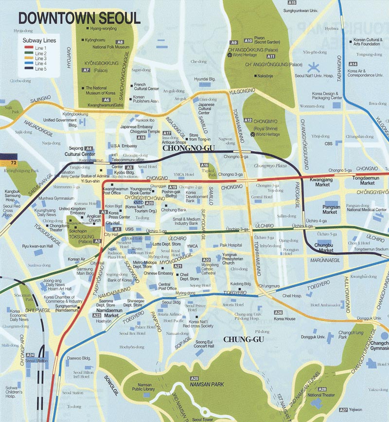
Urban and civil planning was a key concept when Seoul was first designed to serve as a capital in the 14th century. The Royal Palaces of the Joseon Dynasty still remain in Seoul, with the main palace (Gyeongbokgung) currently being restored to its original form. Today, there are nine major subway lines stretching for more than 100 kilometres, with a tenth line being planned.
There are many significant streets to Seoul, but the most historically significant is Jongno, meaning "Bell Street." This bell signaled the different times of the day and therefore controlled the four gates to the city. It is still intact in its original form, and hit ceremonially at 0:00 every New Year's Day. Seoul's most important streetcar line ran along Jongno until it was replaced by Line 1 of the Seoul subway system in the early 1970s. Other notable streets in downtown Seoul include Euljiro (을지로), Sejongno (세종로), Chungmuro (충무로), Yulgongno (율곡로), and Toegyero (퇴계로).
Administration
Seoul is divided into 25 gu (구 "wards"), which are sub-divided into 522 dong, which are sub-divided into 13,787 tong, which are further divided into 102,796 ban in total.

- Dongdaemun-gu (동대문구; 東大門區)
- Dongjak-gu (동작구; 銅雀區)
- Eunpyeong-gu (은평구; 恩平區)
- Gangbuk-gu (강북구; 江北區)
- Gangdong-gu (강동구; 江東區)
- Gangnam-gu (강남구; 江南區)
- Gangseo-gu (강서구; 江西區)
- Geumcheon-gu (금천구; 衿川區)
- Guro-gu (구로구; 九老區)
- Gwanak-gu (관악구; 冠岳區)
- Gwangjin-gu (광진구; 廣津區)
- Jongno-gu (종로구; 鍾路區)
- Jung-gu (중구; 中區)
- Jungnang-gu (중랑구; 中浪區)
- Mapo-gu (마포구; 麻浦區)
- Nowon-gu (노원구; 蘆原區)
- Seocho-gu (서초구; 瑞草區)
- Seodaemun-gu (서대문구; 西大門區)
- Seongbuk-gu (성북구; 城北區)
- Seongdong-gu (성동구; 城東區)
- Songpa-gu (송파구; 松坡區)
- Yangcheon-gu (양천구; 陽川區)
- Yeongdeungpo-gu (영등포구; 永登浦區)
- Yongsan-gu (용산구; 龍山區)
Historic sites and tourism

The Joseon Dynasty built the "Five Grand Palaces" in Seoul, namely:
- Changdeokgung (창덕궁; 昌德宮)
- Changgyeonggung (창경궁; 昌慶宮)
- Deoksugung (덕수궁; 德壽宮)
- Gyeongbokgung (경복궁; 景福宮)
- Gyeonghuigung (경희궁; 慶熙宮)
There is also a minor palace:
- Unhyeongung (운현궁; 雲峴宮)

Temples and shrines:
Museums and galleries:
Outside the metropolitan area:
Higher education

There is a large number of universities in Seoul. Seoul National University is considered the country's most prestigious university and is highly sought after.
The other universities of the city include:
- Chungang University
- Chugye University for the Arts
- Dankuk University
- Dongduk University
- Dongduk Women's University
- Duksung Women's University
- Ewha Womans University
- Hankuk University of Foreign Studies
- Hansung University
- Hanyang University
- Hanyang Women's University
- Hongik University
- Induk University
- Kang-woon University
- Konkuk University
- Kookmin University
- Korea National Open University
- Korean National University of Physical Education
- Korean National University of Arts
- Korea University
- Kyunggi University
- Kyunghee University
- Myongji University
- Sahmyook University
- Sangmyung University
- Sejong University (named after King Sejong the Great of Joseon)
- Seogyeong University
- Seoul National University
- Seoul Women's University
- Sogang University
- Songshin Women's University
- Sookmyung Women's University
- Soongsil University
- Sung Kyun Kwan University
- Yonsei University
Transportation

Seoul's transportation boom dates back to the era of the Korean Empire, when the first streetcar lines were laid and a railroad linking Seoul and Shinuiju was completed. Ever since then, Seoul's transportation has greatly diversified, allowing it to become one of the greatest transportation hubs in Asia. Seoul has nine subway lines, nearly 200 bus routes and six major highways that interlink every district of the city with one another and with the neighbouring metropolitan area, which is the world's most populous. The majority of the population now uses the public transportation system due to its convenience. Seoul is also linked to several other major South Korean cities by the KTX bullet train, Asia's fastest high-speed train, making commuting between cities extremely convenient for commuters and domestic tourists. In addition, in order to cope with all of these transportation modes, Seoul's metropolitan government employs several mathematicians to coordinate the subway, bus, and traffic schedules into one timetable.
Airports

There are two airports that serve Seoul. Gimpo Airport, formerly in Gimpo but now annexed to Seoul, was the only airport for Seoul from its original construction during the Korean War. It long served as the country’s gateway to the world.
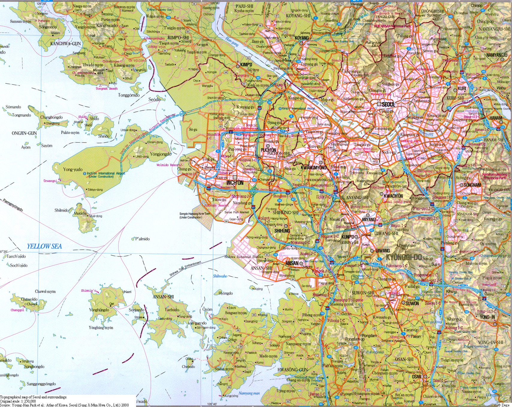
Upon opening in March, 2001, Incheon International Airport in Incheon has changed the role of Gimpo Airport significantly. Incheon is now responsible for almost all international flights, while Gimpo serves mostly domestic flights (with the exception of flights to Haneda Airport in Tokyo). This has led to a significant drop in flights from Gimpo Airport. Meanwhile, Incheon International Airport has become, along with Hong Kong and Singapore, a major transportation centre for East Asia. It was recently voted by IATA as the number one airport in the world. The two airports are linked to Seoul by a highway.
Recreation

Due to the efforts of the government in regard with the environment, Seoul's air pollution levels are now on par with those of Tokyo and far lower than those of Beijing. Seoul's metropolitan area accommodates six major parks, including Seoul Forest, that opened in mid-2005. The Seoul Metropolitan Area is also surrounded by a green belt aimed to prevent the city from sprawling out over the neighbouring Gyeonggi Province. These lush green areas are frequently sought after by people resting on the weekend and during vacations. In addition, Seoul is also home to three amusement parks: Lotte World, Everland, and Seoul Land. Of these, Lotte World is the most frequently visited. Other recreation centres include the former Olympic and World Cup stadium the Korea Finance Building, and the City Hall public lawn. Certainly worthy of mentioning is the level that professional video-gaming has reached in South Korea (the highest in the world). The country has several television channels dedicated to broadcasting video games on TV as spectator sports. A progamer (professional gamer) is a serious profession here. Players get contracts from large companies, much like in baseball or basketball. The fan base, resembling those of some major sports, is large enough to fill grand stadiums for the grand finals of tournaments. There is a lot of support for this form of entertainment. Among the first and most popular video games that made it big in South Korea is Starcraft (by Blizzard Entertainment).
Sports
Seoul hosted the 1988 Olympic Games and was one of the host cities of the 2002 Football World Cup.
Seoul is the home of 2 baseball teams in the KBO: the Doosan Bears and the LG Twins
See also
- List of Korea-related topics
- List of cities in South Korea
- Capital Metropolitan Area
- Geography of South Korea
External links
- Highlights of Seoul: by Korean National Tourism Organization
- Open Directory category
- Satellite picture by Google Maps
- Map of downtown Seoul
- Map of Seoul and environs
- For hip tips on shopping, dining, nightlife and modern culture in Seoul
| Administrative divisions of South Korea | |
|---|---|
| Special City Seoul |
|
| Metropolitan Cities Busan | Daegu | Daejeon | Gwangju | Incheon | Ulsan |
|
| Provinces Chungcheongbuk-do | Chungcheongnam-do | Gangwon-do | Gyeonggi-do | Gyeongsangbuk-do | Gyeongsangnam-do | Jeju-do | Jeollabuk-do | Jeollanam-do |
|

