Mike Breiding's Epic Road Trips: March 2022
Tucson to Morgantown: Part Two
Carlsbad, Throckmorton and Home
Tucson, Las Cruces, Carlsbad, Throckmorton, Paris, Texarkana, El Dorado, Crump, Charleston, Weston, Morgantown
March 2022
Carlsbad to Morgantown with a side of Throckmorton
Another quiet night at the Parkview. After my coffee and banana bread I loaded up the rest of my stuff and headed out the door. I am not quite ready to leave Carlsbad. It's time to take another look at the Pecos River.

The Pecos River in New Mexico and Texas
Source: WikiPedia
The Pecos River (Spanish: Río Pecos) originates in north-central New Mexico and flows into Texas, emptying into the Rio Grande. Its headwaters are on the eastern slope of the Sangre de Cristo mountain range in Mora County north of Pecos, New Mexico, at an elevation of over 12,000 feet (3,700 m). The river flows for 926 miles (1,490 km) before reaching the Rio Grande near Del Rio. Its drainage basin encompasses about 44,300 square miles (115,000 km).
The name "Pecos" derives from the Keresan (Native American language) term for the Pecos Pueblo, [p'æyok'ona]. The river was also historically referred to as the Río Natagés for the Mescalero people.
Source: WikiPedia
"West of the Pecos there is no law
West of El Paso there is no god.”
In the 1880s the Pecos was considered a dividing line of sorts: to the east were the settled and relatively civilized lands, to the west were the wild, lawless and uncivilized lands.
One man by the name of Phantly Roy Bean Jr. declared himself "The Only Law West of the Pecos".
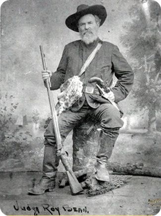
Source: www.wikitree.com
Phantly Roy Bean Jr. (c. 1825 – March 16, 1903) was an American saloon-keeper and Justice of the Peace in Val Verde County, Texas who called himself "The Only Law West of the Pecos".
According to legend, he held court in his saloon along the Rio Grande on a desolate stretch of the Chihuahuan Desert of southwest Texas. After his death, fictional Western films and books cast him as a hanging judge, although he is known to have sentenced only two men to hang, one of whom escaped.Source: WikiPedia
To say Judge Bean was a celebrated and mythical character is a bit of an understatement. He was characterized in no less than 16 movies and TV shows, as well as 9 namesake locations and various print articles.
As a kid I was no stranger to the Wild West and I had heard the phrase "West of the Pecos" and had some idea that was not a good place to be. The television was my teacher about about the west, what with the likes of Pecos Bill, cowboys and Indians, gunslingers and lawmen of both the lawful and the lawless kind.
There were countless western movies and the television channels had plenty of western action, mythology and tall tales to keep a kid occupied and interested.
Here is sampler of some of the Western TV shows we had to choose from in the 1950s and early 1960s.
Bonanza Rawhide Maverick The Lone Ranger Have Gun – Will Travel Gunsmoke Davy Crockett Death Valley Days The Rifleman Wagon Train
Wanted Dead or Alive Frontier Justice Tales of Wells Fargo The Adventures of Wild Bill Hickok Bat Masterson Gunsmoke
I never really lost my fascination with the Wild West and when I first drove both east and west of the Pecos in 2010 I was quite enamored by the landscape and the small western towns many of which still had old stone jails and of course many beautiful and sometimes monumental court houses and miles and miles and miles of quiet roads in between.
Once I got a taste I came back - more times than I can count and I always found something new and interesting if I took the time to look.
I have been in Carlsbad a number of times over the years but until this trip I never took the time to look around. I am glad I did.
How the Pecos River Became
'The Only River That Crosses Itself'

The National Park Service book entitled Watering the Land: The Turbulent History of the Carlsbad Irrigation District explains in detail how all this came about.
Simply put: In the 1880s Lake Avalon was built as a source of irrigation water for the Pecos Valley. Water from the lake was carried south via canals and then crossed the main stem of the Pecos River via the "Flume".
And that is how and why the Pecos became "The Only River That Crosses Itself". It even rated a mention in Ripley's Believe it or Not!. Now the flume is famous!
The Pecos River Flume carries(d) the main canal of the Carlsbad Irrigation District across the Pecos River Channel. The flume was designed by Thomas Taylor Johnston, a civil engineer from Chicago, and constructed in 1903 at a cost of $50,000.
On completion, the 492-foot long by 47-foot high flume was the largest irrigation flume in the United States. Four pairs of arches support a massive concrete trough with a capacity of 15000 cubic feet of water per second.
Floodwaters seriously damaged the flume a year after completion, washing out the banks at either end and undermining the foundation. After purchasing the privately-owned irrigation project, the U.S. Reclamation Service undertook extensive rehabilitation of the flume in 1906. The wingwalls were extended and the width of the foundations increased. The Civilian Conservation Corps added stone masonry cutwaters in 1939.Source: Library of Congress
Click on the photos below for a larger image.

My first look at the "flume" in the early morning light. I use quotes because this is not a flume. A flume is for transporting materials using flowing water. An aqueduct is used to transport water and water only.
Aqueducts have been around for a long time and the Romans built some monumental ones.

Mike Breiding at the Aqueduct of Segovia October 2010
Photo: Jeff Bruner
The Romans constructed aqueducts throughout their Republic and later Empire, to bring water from outside sources into cities and towns. Aqueduct water supplied public baths, latrines, fountains, and private households; it also supported mining operations, milling, farms, and gardens.
Aqueducts moved water through gravity alone, along a slight overall downward gradient within conduits of stone, brick, concrete or lead; the steeper the gradient, the faster the flow. Most conduits were buried beneath the ground and followed the contours of the terrain; obstructing peaks were circumvented or, less often, tunneled through. Where valleys or lowlands intervened, the conduit was carried on bridgework, or its contents fed into high-pressure lead, ceramic, or stone pipes and siphoned across.
Source: WikiPedia
I first became acquainted with flumes when I saw them in the Sierra mountains of California. They had been built to float logs to a place where there was a mill or to a landing area for transport by river or rail.

Rochat Creek Five Mile Log Flume, Idaho (www.amusingplanet.com)
Ok, now that we have established Carlsbad does not have a flume, let's get on with the show.

Roadside historical marker - Carlsbad Flume

An architectural photographer I am not so what you see is what you get.

Source: Library of Congress
The Wooden Flume was builtin 1903. Floodwaters seriously damaged the flume after completion in 1906 and it was rebuilt using concrete.

Looking north through the flume.

Concrete flume - circa 1906 Carlsbad NM
Source: Library of Congress

This is looking south into the former canal channel.

I imagine more than one person new to the area has mistaken this for a railroad or auto bridge.

Shown here is the backwater of the lake. On the maps it appears the Pecos waters the lake but that is not the lake's only water source.

The stone structures at the base of the arches are cutwaters. The Civilian Conservation Corps added stone masonry cutwaters in 1939. The cutwaters divert water and debris around the arches to minimize damage and wear to the base.
An interesting feature of many multi-span stone arch bridges is cutwaters — protrusions of stone attached to piers that improve the hydraulic properties of the bridge. Cutwaters not only help to prevent scour, they also prevent the accumulation of debris against the piers.
Source: Stone Arch Bridges

Here is the Carlsbad Spring which feeds Carlsbad Lake. But not just this spring.
In January 2008, the City of Carlsbad drained the lake along the Pecos River, created by the Upper Tansill Dam, to conduct normal maintenance along the shoreline. The lake inundates all but one of the springs that provide the baseflow to this section of the river.
Dozens of springs were discovered, many small and next to each other, and appeared to form possibly six distinct groups.

The caption for this photograph at the LOC site is "Carlsbad's famous spring. Discharges 4,000 gallons daily".
That may have been the case in the early 1900s but the current flow rate? I could find no information on that. It is a really interesting spring and worth a visit if you are in the area.

A last look at the flume and lake which looked very inviting even on this chilly morning.
Now it is time to continue east to Throckmorton and the beautiful oaks which lie just to the east of town.

2005
My first visit to the Throckmorton Oaks was in the winter of 2005 while on my very first solo Epic Road Trip. I was on my way to Tucson to visit brother William and having a great time exploring all the back roads.
There I am in Morgantown with my 13 year old 1989 Plymouth Reliant which I had recently purchased from a neighbor for $350. The route overview base map was from DeLorme Street Atlas software which I marked up. This was pre Google maps and DeLorme Street Atlas was the dominant digital road atlas and routing software. My how times have changed.


On August the 20th 2006 the Plymouth met an early demise and almost took Betsy along for the ride.

Texas Roadside Rest - 4 miles east of Throckmorton on US 380
How sweet it was being under the oaks for the first time. I remember sitting at that concrete picnic table and having a snack before getting back on the road.
Quercus fusiformis (also often referred to as Q. virginiana var. fusiformis), commonly known as escarpment live oak, plateau live oak, plateau oak, or Texas live oak, is an evergreen or nearly evergreen tree. Its native range includes the Quartz Mountains and Wichita Mountains in southwestern Oklahoma, through Texas, to the Mexican states of Coahuila, Tamaulipas, and Nuevo León.
Like Q. virginiana, its magnificent, stately form and unparalleled longevity has endeared it to generations of residents throughout its native range. Its low hanging branches are a favorite for local children to climb and play in.
Source: WikiPedia

The Throckmorton Oaks - a birds-eye view.

2011
Here is Betsy at the picnic table under the Throckmorton Oaks. If you look closely you can see a brick barbecue in front of the van and to the left a trash can on a post.

2012
One year later the picnic table, barbecue and trash can were all gone. The Texas DOT had decided to take this rest area out of service. What a shame.

The 2008 Hyundai Entourage odometer reading in 2012 - 77k. It now has 240k miles on it and is running strong.
2022
Now, 10 years later I am back in Throckmorton. From that first visit in 2005 I always thought it would be cool to spend the night there but the timing was never right. On this visit I made sure it was.
In February I contacted Will Carroll the Mayor of Throckmorton about staying the night there. He had this to say.
I’m not sure about overnight camping there since it is not a rest area any more. I would say calling the Sheriffs office would be a good idea.
Will Carroll
Mayor / Municipal Judge
City of Throckmorton
Box 94 Throckmorton TX 76483
949-862-3107
Throckmortontx.org
I decided to email Sheriff Doc Wigington and check with him. I did not hear back from him. I eventually called the Sheriff's office and the person I spoke to assured me the officers would be alerted about my overnight stay at the Throckmorton Oaks. OK! Now I am all set.

It was late afternoon when I arrived in Throckmorton and it was cool and quite windy.

I had arrived early so I decided to check out the Oaks before settling in for the night.
They were still there - and they had grown! I could barely get the van underneath the low hanging branches.

By now even the concrete apron and pad were in rough shape and unfortunately the locals had found a new use for this now closed Texas Roadside Rest.

Here are my "room mates" for tonight - two coyotes and a bob cat. Some sick individual had engaged in these thrill kills and unceremoniously dumped the carcasses here at the old rest stop. Pathetic!
I was very glad it was cold and windy or the stench might have been difficult to tolerate.
After heading back to town for a thermos of coffee I returned to join my three new friends and settled in for the night.
About 6:00 I caught a movement in the rearview mirror and noticed a vehicle had pulled in behind. Not just any vehicle - a sheriff's patrol car.
Perhaps this was the welcoming committee?
An officer got out of the vehicle as did I. He said he wanted to make sure nothing was wrong. I assured him it wasn't and then told him about my contacting the department to alert them I was staying the night. He made no comment, bade me farewell and took off down the road.
Not more than 20 minutes later a black pick-up pulled in behind me. Out stepped two guys one of which had a badge clipped to his belt.
He said they had gotten a call someone was out here and they were there to investigate. I then explained in detail about my contacting the sheriff's department twice about staying there. They said they knew nothing about that.
The guy with the badge went back to his truck and got on the radio while the other one stayed close and made an attempt at small talk.
Finally Mr Badge comes back and starts grilling me about why I was staying there. And did I know there was lodging in Throckmorton and on and on and on. I actually thought he was going to tell me I had to move.
Finally they left, although they still seemed suspicious about who I was and what I was doing there. Such friendly folks!
I had a quiet night there under the oaks although every time I heard a vehicle go buy I wondered if I was going to be rousted and told to git. Fortunately that did not happen.
Then next morning I had my luke warm coffee from the thermos and banana bread and I was on my way down the road. Next stop: El Dorado Arkansas.

I first visited El Dorado in 2010 and enjoyed poking around the downtown area which is full of interesting old buildings. That trip report is here.
In 2020 Betsy and I drove home to West Virginia from Tucson. An unexpected trip I called "Mr Corona Chases Us Home". We stopped in Throckmorton and El Dorado. Unlike my previous visit in 2010 downtown El Dorado was like a ghost town and all the shops and restaurants were closed. That 2020 trip report is here.
I spent the night at the "Econo Lodge Conference Center" which had obviously seen better days. But the rates were the lowest in town.
The drive the next day to Crump TN was woodsy and pleasant and by late afternoon I was in Pusser Land.

The River Heights Motel is in Crump TN. Crump is just east of McNairy county where Buford Pusser was sheriff.
Buford Hayse Pusser (December 12, 1937 – August 21, 1974) was the sheriff of McNairy County, Tennessee, from 1964 to 1970, and constable of Adamsville from 1970 to 1972. Pusser is known for his virtual one-man war on moonshining, prostitution, gambling, and other vices along the Mississippi–Tennessee state line. His efforts have inspired several books, songs, and movies, and a TV series. He was also a wrestler known as "Buford the Bull" in the Mid-South.
The Buford Pusser Museum was established at the home he lived in at the time of his death in 1974. A Buford Pusser Festival is held each May in his hometown of Adamsville, Tennessee.
Source: WikiPedia

Source: AndyWolverton.com
The 1973 movie "Walking Tall" was a huge hit and deified the larger than life Sheriff Buford Pusser.
I am now just two days drive from being on the doorstep of Cabin №18 and today would be a long drive for me, 9 hours of Interstate driving. Ugh.
My next stop would be an overnight in Charleston WV to visit long time friends Julian, Jeff and Colleen.

It had been a while since I had seen Jeff and Colleen and it was good to catch up. They are both newly retired and very much enjoying it.
Back in the early 90s Jeff was already well versed in the ways of GIS as I was just becoming aware of it and Jeff helped me along this path.
In the mid 60s the Breiding family met Julian Martin which changed us all forever.
Julian is getting up there in years but is still sharp, inquisitive and insightful. I had a really nice visit with him and we spent quite a few hours reminiscing about the old days in Morgantown, San Francisco, Africa, Cuba and on and on. It was great fun.
I said my farewells to Julian and then headed north up I-79.

I had already had enough interstate driving so I exited I-79 at Big Otter and took a very twisty-turny route (red line on the map) the rest of the way to Tom and Becky's. It was quite enjoyable and made me feel I had definitely arrived back home to the bosom of my Mountain Momma.
Some of you met Tom and Becky when they took us exploring in the Chautauqua Creek Gorge.
The next day I departed Tom and Becky's and within two hours I was back at Cabin №18.
As of this writing that was nearly 6 months ago.
I have thought about this trip a good bit over the summer and realized it was time for a break from the Tucson to Morgantown and Morgantown to Tucson drives.
I have so many of those trips under my belt now it is becoming rote. Although I must say I have had some mighty fine ERTs over the last couple of years.
But for now - enough is enough.
And so this year there will be no drive to Tucson for me. When the 21st of September rolls around Betsy and I will both be on a plane and instead of 6 days in transport it will be 6 hours. I can never quite get used to that.
The end of an era? Perhaps. Until I get the itch again.
Until then...