Mike Breiding's Epic Road Trips: June 1997~
The Big Trip
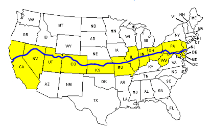
13 States and 5000 miles
West Virginia → Ohio → Indiana → Illinois → Iowa → Missouri → Nebraska → Kansas → Colorado → Wyoming → South Dakota → Minnesota → Wisconsin → Michigan → Indiana → Ohio → West Virginia
Posted: August 2020
Intro: The Big Trip (aka Iowa Road Trip)
Perhaps the main inspiration for The Big Trip (intertwined with some other factors I will explain below) was The National Road.
My dad (1917 - 2007) grew up in a house on the National Road (US 40) in the small community of Fulton which was a neighborhood in Wheeling WV. The house, #487 was across the road from the Bank of Fulton. And just two doors down at #495 lived my dad's sister Martha and her husband Russ and two kids Tim and Mark.
Like all the rest of the houses along this section of the National Road my grandmother's was perched up on a hillside and required walking up 20 or so steps to get to the front door. When I was a kid looking up those steps seemed like walking up a mountain.
I have memories of sitting on my Grandma Breiding's porch watching the traffic go by which was a novelty since our family lived on a quiet country road.
I also remember my cousins Tim and Mark being there. Mark was particularly interested in cars and could name the make and model of any car as they went by on the National Road. This amazed me. He also knew how to get the big trucks to blow their horns by mimicking the hand pull they used to sound them.
This was big fun! And I remember my Uncle Russ Reasbeck telling me "That road goes all the way to California". I doubt I knew where California was but I was impressed.
Source: Route40.net
Today Interstate 70, which replaced most of the National Road (US 40) passes through Wheeling and US 40 is now just a fragmented local road. The first portions of I-70 in West Virginia did not open until 1963 so in the 1950s both local and long haul trucks used US 40 which ran right past my dad's house and that of his sister and family who lived two doors down.
Think about all the trucks one sees today on I-70. Although all truck traffic had to use US 40 before I-70 was built the volume was a fraction of what it is today. Although I have no way to verify this I think it was because most cargo was were shipped by rail. Today the rail system is a mere shell of what it was and trucks move just about everything.

Breiding House at 487 and Reasbeck House at 495 National Road, Wheeling WV. If you are craving more info about the Breidings and Reasbecks you can find out more here.
The National Road, in many places known as Route 40, was built between 1811 and 1834 to reach the western settlements. It was the first federally funded road in U.S. history. George Washington and Thomas Jefferson believed that a trans-Appalachian road was necessary for unifying the young country. In 1806 Congress authorized construction of the road and President Jefferson signed the act establishing the National Road. It would connect Cumberland, Maryland to the Ohio River.
Source: Federal Highway Administration
In 1926 the National Road became part of US 40 as a coast-to-coast highway. It started in Atlantic City New Jersey and its terminus was in San Francisco, California. However the section of US 40 from Silver Summit, Utah to San Fran was replaced with Interstate 80.
It seems that I am going around the mulberry bush so let me try to get to the point of this.
Having learned about the National Road as a child when I started travelling it meant more than just another road sign when I would see us the US 40 symbol.

I am sure both my dad and my brother Bill probably mentioned their RT 40 experiences to me and this is what piqued my curiosity and got me thinking about exploring some of the remaining nearby segments in Maryland, Pennsylvania and Ohio and of course West Virginia.
At some point I became interested enough I started looking for books about The National Highway. Remember, this was 1996 and Amazon was only two years old and Interloc had not yet evolved into Alibris. Perhaps I found what I was looking for the old fashioned way - by searching Books in Print which by then could be accessed from a CD. But, damn! I loved flipping through those tissue paper thin pages of Books in Print.
I also started nurturing a fantasy about cycling from Atlantic City to San Francisco but once I found out how much of the original route had been replaced by interstate I gave up on that idea.
Somehow I found out about a book published by the University of Wisconsin Press entitled "U.S. 40 Today: Thirty Years of Landscape Change in America" which I decided to order even though it seemed a bit pricey at 14.95 + 3.00 shipping.

The Vales based their 1983 book on a previous book considered a classic: "U.S. 40: Cross Section of the United States of America" (1953) by George R. Stewart. Here are the details from a summary on the inside front cover of the Vale book.
(Short version: In 1953 Stewart took photos of places along US RT 40. In 1983, 30 years later the Vales stopped at the same spots and took comparison photos.)
In 1953, George Stewart published a compelling photographic record of his cross-country journey from Atlantic City to San Francisco. U.S. 40 was immediately acclaimed as a minor classic, unique and conception and important in its penetrating analysis of America's natural and cultural landscape.
Now 30 years later, geographers Thomas R. Vale and Geraldine R. Vale have retraced Stewart's probing tour documenting their own voyage of discovery with an updated series of photographs and commentary. The result, as keenly observed and recorded as the original, is both a perceptive assessment of landscape changes in the United States over the past three decades and a spirited, often inspiring, and distinctly American travelogue. a
Anyone interested in our national scene, from its geography and its popular history to its cultural and natural panorama, will be enthralled by the celebration of an evolving, diverse, and representative length of American landscape.At the core of the Vales' work are seventy three photographs, grouped into seven geographical regions, that record the authors' progress west along Highway 40. Each of these photographs is paired with a corresponding picture of the same site shot 30 years earlier by Stewart. The lesson is a telling one. By visually juxtaposing past and present, the Vales are able to represent dramatically, and reflect upon, the changing landscape of America. Their assessment encompasses a world in transition. There are conspicuous and subtle changes, natural and cultural changes, local and widespread changes. Yet the Vales are not dogmatic. If their photographic pairs and commentary expose the mutable, they also, at times, reveal surprising pockets of constancy, even status, along highway 40. Ultimately the sequence of thoughtful observation begins to communicate the rich spirit of a nation's landscape, eliciting our own appreciation and compelling us to take another, closer, look around.
The Vales, in fact, invite this participation. They record not merely the objective evidence of physical and cultural change but the highly personal experiences and feelings of sensitive cross-country travelers. The joy, as they intend, is infectious. We follow their progress - from Atlantic City through Baltimore, Columbus, Kansas City, Denver, Salt Lake City, and Reno, finally reaching land's (and highway's) and San Francisco - with pleasure and involvement, partners in an ebullient rediscovery of a transformed, yet sometimes marvelously immutable, America today.
Thomas R. Vale is a Professor of Geography at the University of Wisconsin-Madison. He has contributed articles on American ecology and landscapes to a number of scholarly and environmental journals. As evidenced by this work, he is an inveterate traveler, and accomplished photographer, and a sharp observer of the American landscape. Geraldine R. Vale is a teacher in the Madison public schools. She handles classes in English and geography, and has published in the professional literature.
Source: U.S. 40 Today: Thirty Years of Landscape Change in America
OK, so now we have the US 40 - National Road element of this trip. Betsy and I thought it would be really cool to take a road trip which focused on visiting the old, still intact sections of the National Road. But what really tipped the scale on planning and actually taking this trip was my brother Bill.
You remember my brother Bill, right? In 1995 I visited him in SF and then in 1996 Betsy and I stayed with Bill at his Market Street digs.
Now, about a year later in June of 1997 we are visiting Bill again. But not in San Francisco. This time it will be in Fairfield, Iowa where Bill moved after living in SF for 23 years.
And so on June 7th of 1997 we hit road in search of an older America, the National Road America. And although this trip was originally conceived as an "Iowa Road Trip" it evolved into a trip in which we planned to reunite with some our Honeymoon destinations from 15 years previous and visit some of America's most treasured "apple pie" places.
After reading those last couple of paragraphs I'll bet you thought we were ready to hit the road. Not quite.
In 1997 I barely had the use of email and the idea of posting about our trips to "The Web" was still several years off. Instead of trip reports on the web (blogging) Betsy and I had photo albums - like everyone else. And, thankfully Betsy's delightful journals!
But this trip we decided to do something different which was not actually different but had simply fallen out of favor - make a scrap book. How old fashioned!
Click on the photos below for a larger image.

Can you even find these anymore? Faux leather with gold string binding! They used to be in every department store and they were cheap.
"Scrapbooking" became all the rage a few years back and turned into a big money operation. You could even watch videos on how to do it! Now it seems to once again have fallen out of favor. It was boom and bust like so many fads and at one time over 1,600 companies were creating scrapbooking products by 2003. One of the biggest, Creative Memories with $425 million in retail sales in 2004 went belly up in 2013.

Our scrapbook covered travels for the entire year, not just The Big Trip.


My, oh my how mapping has changed. The above was printed from DeLorme Street Atlas 3.0 which I delighted in using. Google maps changed our view of the world - literally.

Some sample pages showing the photos we took, brochures we came by and Betsy's captions. I scanned the scrapbook photos and used them here to compliment Betsy's journal entries.
OK! I think we are finally ready to start this trip.
⋄⋄⋄⋄⋄⋄⋄⋄⋄⋄⋄⋄⋄
Part 1
Morgantown WV to Sharon Springs KS
Iowa Road Trip
Journal of Betsy Breiding
June 7th to the 25th
Saturday June 7th 1997
We had a good beginning to our trip. We got everything done in a very organized way, left the house in great shape for Angela, and didn't yell at each other once.
We left the house about 8:30. It was cool and cloudy. We took secondary roads most of the way to Tom's in Columbus and arrived around 12:30. We got the tour of Tom's new place and met his new cat, Tanner. The new house is fairly nice (but the bathroom is still dirty)!
We went downtown to the Art Festival, then ate at Hoster's Brewery. I had a delicious hummus and cucumber sandwich and a glass of Cabernet (what sacrilege, at a brewery).
Now I'm upstairs by myself getting in some much needed alone time, while Mike and Tom drink beer downstairs and get nostalgic over old Oglebay Camp photo albums.
Tomorrow we head to Illinois.
Sunday June 8th 1997
We left Tom's about 8:30 and headed west on Rt. 40. The weather was cloudy and chilly - probably in the 50's. We watched for several of the landmarks in the "Highway 40" book and found the Red Brick Tavern, but we think the Victorian house must have been torn down. We thought we found the site, though. We stopped and talked to several area folks about it, but nobody really knew anything. However, there were lots of interesting sights along the road and lots of neat old houses to look at.


This old tavern was built in 1837 and is said to be the 2nd oldest tavern in Ohio. The "Trail Tavern", which opened in 1827 in Yellow Springs is the oldest.
Betsy is at far left.

Stewart's photo from 1953 entitled "Victorian Elegance" shows just that. The house and grounds are being kept up and the "elegance" maintained.

Vale's 1983 photo 30 years later shows the house in obvious decline and the grounds untended and overgrown.

Now the old place is no more.
We took Rt. 40 around Indianapolis and then picked up Rt. 36 which we took into Illinois and up to the town of Monticello (population 4500) around the Decatur/Champaign area. We found the Foster Plaza Inn, checked in, and then went for a walk. We found it to be a quaint little town with some great houses. We even found the house of an older gent who was a peony hybridizer although we didn't get to meet him. There was a yellow peony in his yard!
We ordered a pizza from Fillipo's Pizza (a very strange affair) and then relaxed in our room to the accompaniment of large equipment tearing out the pavement of the bowling alley next door. It's now about 6:30 Sunday evening. I hope they're almost finished!!!
Monday June 9th 1997
I got up for an early morning walk and heard a parula warbler in the park! I also drove to Hardees and brought back coffee and two cinnamon raisin biscuits. We hit the road about 7:30 and were soon on Rt. 10 driving across Illinois.

Although not mentioned in Betsy's journal, we stopped in Havana IL to check out the old water tower.
The Havana Water Tower is a historic water tower which stands in Havana, Illinois. Built in 1889 and designed by F. William Raider, it holds 50,000 gallons and was the town's only water supply until 1962. The brick water tower is approximately 86 feet (26 m) tall. It was designated an American Water Landmark by the American Water Works Association in 1982 and was listed on the National Register of Historic Places in 1993. It still operates today.
Source: WikiPedia
We missed our turn and ended up on a different route which took us to Carthage where we stopped to see the historic Carthage jail. We didn't realize the town, etc. was run by the Mormons and that Joseph Smith and his brother had been murdered there. The brochure we picked up made us decide to drive over to Nauvoo, the 1800's Mormon settlement. We were short of time, so we didn't do the movie and tour, but we drove through the old town and stopped at the bakery for some Nauvoo blue cheese ($3.39 a lb.)

Carthage Jail is a historic building in Carthage, Illinois, listed on the National Register of Historic Places (NRHP). It was built in 1839 and is best known as the location of the 1844 killing of Prophet Joseph Smith, founder of the Latter Day Saint movement, and his brother Hyrum, by a mob of approximately 150 men. It was added to the NRHP in 1973 and is operated by The Church of Jesus Christ of Latter-day Saints (LDS Church) as a historic site with an adjacent visitors' center.
Source: WikiPedia

Betsy and the proverbial "Brick shit house".
Forgot to say that we drove along the Great River Road, a road that runs along the Mississippi, before we crossed over into Iowa. It was very scenic, with views of barges coming down the river.


Maps from our Big Trip scrapbook.
Fairfield is not what most people would think of when one mentions small town Iowa. It has been the home of Maharishi International University (called Maharishi University of Management 1995–2019) since 1974 and has been referred to as "the world's largest training center" for practitioners of the Transcendental Meditation technique. Go figger.
Fairfield's library, the first in the state of Iowa, became the first Carnegie Library outside of Pennsylvania or Scotland funded by Andrew Carnegie, who donated $40,000 to build the library.
And Fairfield has 12 public parks and recreation areas consisting of more than 1,300 acres. Not bad for small town Iowa with a population of about 10,000.
We got to Bill's about 3:00, took a walk, met his roommate Christina, and had some of his famous chicken.
We went to bed quite early and were awakened frequently by the nearby trains.
Tuesday June 10th 1997
Morning dawned clear and I went out for a walk around 5:45 a.m. Bill was already up and had made coffee.
After breakfast, Mike and I went for an hour long walk down to Chautauqua Park, a great place with big trees and a woodsy feel to it. Then we lounged with Bill and Christina in their pleasant backyard.


The red Mazda hatchback is what we were driving on The Big Trip. It was totalled 2 years later on June 23rd - Betsy's birthday. As we were driving to a Bed and Breakfast in Appleton WI to celebrate, a pickup truck blew through an intersection and t-boned us. The cartop carrier seen above became air born and landed in a farmer's field. That was not a good day.
I've been enjoying Christina's cats - Moogie, Sophy, Rudy and Mommy. They're all variations of black and white.

Kitty, kitty, kitty...
After a walk to the courthouse and some lunch, Mike and I took a fifteen mile bike ride - my first in 6 months! The small hills just about did me in - I must be really out of shape!
We went to a Mexican restaurant for dinner. It was pretty good.

Wednesday June 11th 1997
Another beautiful morning. I took a half hour walk around 5:45 a.m. We packed, said good - bye to Bill, and finally got underway about 8:30 a.m.
We really enjoyed driving through Iowa and enjoying its tiny little towns with their parks and courthouse squares.

40 miles southwest of Fairfield we went through Bloomfield home to the monumental Davis County Courthouse.
The Second Empire structure was designed by the Fort Wayne, Indiana architectural firm T.J. Tolan & Sons. John Lane supervised construction and Larkworthy and Menke of Quincy, Illinois did the stonework. The Kimberly Bell Works of Troy, New York cast the bell, and the Seth Thomas Clock Company provided the four-faced clock. Both date from 1876. The building itself was completed in 1877.
Source: WikiPedia
As soon as we got into Missouri things looked dirty and ill-kempt, but maybe that was just the area we happened to be in.
We zigzagged back and forth on little roads and managed to be in 4 different states.
By late afternoon we arrived in Marysville, Kansas, looking for a place to stay. As we approached the town, things looked more and more ominous weather wise. Lightening cracked, the skies were dark. Suddenly all hell broke loose! Police ahead of us were waving motorists to the side of the road. As we pulled over, the wind increased. Trees bent and things flew through the air. The rain beat down so hard we couldn't see out of the car - then it changed to hail. The car began to rock and I was afraid we would go over at any moment. Later we found that a tornado had touched down just southeast of us. I never want to be that close to a tornado again.

Somewhere between Marysville and Washington Kansas.
We tried to find a place to stay in Marysville, but all the motels were booked up with work crews, so we went to the next town down the road, Washington, Kansas, and found a nice little motel called the K Motel for $27 a night.

We also found that the "Bike Across Kansas" bike tour was in town for the night and some were at our motel, so that was interesting. We talked to some of them, and one woman is going to send us literature about the tour. Also they have a web site.
We ate dinner at the Long Horn Bar and Grill - we ate in the bar with "the locals." I had a Monterey Chicken Salad (ice burg lettuce with fried chicken strips) and Mike had chicken - fried steak.

Larry is gone but the party goes on!

About 3 hours west of Washington KS is the ghost town of Nicodemus. Betsy and I stopped for bit a to wander through the old settlement and look over the remaining structures. In November 12, 1996 it was established as a National Historic Site and is managed by the National Park Service. That was a little over a year before we visited.
Formerly enslaved African Americans left Kentucky in organized colonies at the end of the of post-Civil War Reconstruction period to experience freedom in the "promised land" of Kansas. Nicodemus represents the involvement of African Americans in the westward expansion and settlement of the Great Plains. It is the oldest and only remaining Black settlement west of the Mississippi River.
Source: NPS
Betsy transcribed the above Historical Marker using Google voice transcription which has turned out to be very handy.
In July, 1877, Negro "exodusters" from Kentucky established a settlement here in the Promised Land of Kansas which they named Nicodemus. Although the colonists lacked sufficient tools, seed and money they managed to survive the first winter, some by selling buffalo bones, others by working for the Kansas Pacific railroad at Ellis, 35 miles away. In 1880 the all-Negro community had a population of more than 400.
Their industry brought approving notices in Kansas newspapers. One story concerned a farmer who with one cow "broke and improved twelve acres of prairie and cultivated eight acres of corn: his wife drives the cow and keeps the flies off." Another spaded a four-foot hedge row around 160 acres of land. Edward P. McCabe, who joined the colony in 1878, served two terms as state auditor, 1883 - 1887, the first Negro to hold a major state office.
By 1887, Nicodemus had churches, stores, lodges, a school and two newspapers, but its future was blighted when a projected railroad failed to materialize. Nevertheless, these pioneers who built so much with so little hold a proud place in the Kansas story.
Erected by State Historical Society and State Highway Commission
Thursday June 12th 1997
A clear morning that turned quickly overcast. We got coffee from the gas station across the road and were soon on our way to Oakley. As we drove west, the clouds pulled back and left a beautiful blue sky. We got to Oakley around noon and were sorely disappointed. It was desolate and depressing and we couldn't find the place we had stayed on our honeymoon.
After eating lunch at the "Daylight Donuts" place, we opted to head down the road to Sharon Springs. Once there we found a little Mom and Pop motel with picnic tables under the tall shade trees and that's where I'm sitting now, enjoying the breeze and listening to an oriole sing.
Mike has gone for a bike ride. Seibel Motel $29.00!!

At the "Daylight Donuts" Betsy mentions above we had the maps out and were trying to get an idea of how far the next town might be where we could spend the night. A few tables from us an elderly gentlemen dressed in rough, western style work clothes asked us kindly where we were heading. We explained we were not yet sure but were hopeful we would find lodging not too far from Oakey. It was then he told us there was a place in Sharon Springs "not far from the Colorado line" which had a small motel and we might try that. We thanked him and were on our way.

The Seibel Motel. Cozy, comfy and quiet. Gone, but not forgotten...

Betsy's Relaxation Station at the Seibel Motel.
As we were deciding on supper plans, the weather took a turn for the worse. We walked downtown to look for a place to eat, found that the Eagle Tail Restaurant wasn't open, so we went to the Hideaway for a drink and munchies. The bar had tractor seats for barstools! As we left the bar, the sky looked so black and threatening that we decided to go back to the hotel and "batten down the hatches" before supper. Sure enough, we found out there was a tornado warning for our county. The rains came! - and delayed our supper - but the tornado missed us.
Dinner at the Eagle Tail was "smothered" burritos - quite interesting. After a drive out of town (on which we saw prong horned antelopes) we retired to our king sized bed in the Seibel Motel and a Hawaii Five - O rerun.
The next day we headed west towards Colorado and it was indeed "not far from the Colorado line" as the gentleman in Oakley had told us - just 10 miles down the road.
And so ends Part 1 of our Big Trip.
Next stop - the Gunnison Country.
See you then...
Mike and Betsy
⋄⋄⋄⋄⋄⋄⋄⋄⋄⋄⋄⋄⋄⋄
The Big Trip: Part 2:
The Gunnison Country, Exploring Denver
and our retreat to Boswell Creek
Friday June 13th 1997
Friday the 13th.
We left Sharon Springs and drove West toward Pueblo. The foothills appeared - a beautiful sight!

The towns along the way were small and decrepit and definitely on the decline.
In Pueblo we went grocery shopping, then headed across 96 for Gunnison. The scenery was spectacular - aspen groves, meadows full of thousands of iris, snow capped peaks and luxuriant lilacs!
We couldn't remember where we had camped last time and decided to try the Amaron camp ground, but it turned out to be right along Rt. 50 - bummer. So after looking at the map, we decided we had stayed at the South Rim campground, and headed there. By this time Mike had been driving for about 10 hours and had a pounding headache.
We found the national monument much more developed than on our visit 15 years ago (big surprise). There is no longer a marked trail to bottom of the canyon on the general map - and you have to get a permit to hike down there. The campground now has a multi - media show in its amphitheater!
There are kids in the campsite that backs against ours - what fun! We think we'll move tomorrow.
We dined on sirloin steak cooked over juniper, noodles with Nauvoo blue cheese sauce and salad accompanied by a dry white wine for me and a Pabst extra light (70 calories) for Mike. After supper we took a walk along the rim trail - great scenery! We returned shortly after 9:00. A thunderstorm drove the campground residents "in - doors" and made for a quiet sleeping environment. Thank God for Therma - rest!
Saturday June 14th 1997
A clear and beautiful dawn! By 8:30 we were ready to take off on our bikes for the monument road and overlooks. We soon found that even seemingly gentle grades took quite a toll at this elevation. Views from the overlooks were breathtaking. The weather turned threatening again and there was thunder and rain spatters as we pedaled furiously toward the farthest overlook where we figured we could take shelter in the outhouses if necessary. But the changeable weather cleared again, so we ate our lunch at a picnic table in a juniper grove. It was so peaceful - almost no one else was there.

At the overlooks, the white throated swifts and violet green swallows were everywhere, careening perilously close to our heads sometimes as they dipped and soared. Then we heard it - the melodious far away descending notes of the canyon wren!
We returned to the campground approx. 1:30 and had salsa, chips and beer. Almost everyone has moved out of the campground and it's very quiet, so we're enjoying it now and will take a drive this evening when things rev up again.
We had an early supper then drove down to the East Portal Campground. The campground didn't look familiar to me, but I remembered walking along the road next to the river.
While we were gone it rained - the weather changes back and forth so quickly here - and of course I left the salt and pepper out. Thank goodness we won't need it for the hot dogs tomorrow night.
The campground is quieter tonight.
Two things of interest I forgot to mention. As we walked to the overlooks today, we began to hear clicking noises. I suggested it might be cicadas and sure enough, there were hundreds of cicadas about the size of the tip of your little finger.
Also the ranger who gave us the permit to hike down to the river had been to the Morgantown area many years earlier doing white water rafting on the Cheat and New Rivers.
Sunday June 15th 1997
It's about 6:45 a.m. and we are sitting in our little "sunroom" at the front of the campsite drinking coffee and listening to the birds. I got up about an hour ago, made coffee and watched the sun rise. Soon we head down into the canyon - Yikes!
It took us an hour and a half to hike down into the canyon. The trail was slightly hairy in spots - we thought several places were worse than the one with the chain. There was tons of poison ivy at the bottom. We stayed for awhile and then started back up.

Here Betsy enjoys the shade of a large Ponderosa Pine next to the rushing waters of the Gunnison River.
When Betsy and I were here in 1982 on our Honeymoon the water was not nearly as high and we met two guys who had backpacked down into the canyon to do a little trout fishing.

Betsy's Honeymoon Journal:
Thursday, May 20th 1982
At the bottom we met two guys who were camping and fishing and they offered to share the brown and 14" rainbow trout they'd just caught. So they took them right out of the river, gutted them and cooked them on a grill over the fire. They were great!

Gutted, cleaned and ready for the fire!

What Betsy did not mention in her 1982 Honeymoon journal was this: along with the trout they also had some cans of Coors beer (aka Colorado kool-aid) chilling in the icy river. They asked us if we wanted to help them out by having a few so they would not have to pack them out back up the canyon. What did we say, you ask? Fresh trout and icy beer in a gorgeous setting with good company. How lucky can you get?
The steep climb out of the canyon was pretty rigorous, but not as bad as I remembered. We encountered 16 people on our way back up, the last of whom was a ranger on his way down to check on the hikers (Ted Moe).

If you look carefully you can see the heavy steel chain which is there as a "just in case".
Back at the top we bought books, etc. at the Visitor Center and Concession Stand. Mike bought a book called Gunnison Country and the ranger on duty (Dale Culver) said it was written by one of his professors at the college at Gunnison.
We drove to Montrose in search of a milk shake and some information on roads to take tomorrow. An old codger at the Chamber of Commerce was a wealth of information, but we struck out on the milk shake.
Back to the camp for salsa and chips and beer. We tried to nap in the tent, but it got too hot.
We took the rest of the afternoon and early evening to reorganize and pack up everything we could so we could roll out early in the morning. Hot dogs and beans for supper, then campfire, *** and bed. We were surprised to hear a night hawk!
Monday June 16th 1997
Boy, was I sore this morning!
The huge RV that pulled into the campground and revved up their generator last night turned it on again this morning at 6:45. Mike went over to tell them that quiet hours were 10:00 to 7:00, so the man turned the generator off, but at the dot of 7:00, he revved it back up and yelled "Asshole!" As Mike said, "the ugly camper"!
We were packed and out by 7:30 and had more beautiful scenery. We pulled off at one point to watch a "housing development" of cliff swallows. There were hundreds of them flying back and forth from some muddy areas to the cliff wall to build their "houses." They almost looked like swarming insects.
Aspen was a huge disappointment! I remembered it as a quaint little town, and it's now a crowded yuppy tourist trap!
It turns out that the 16th and 17th are "Bike the Rockies" days in Colorado. We saw quite a few cyclists going over Independence Pass!

This is Twin Lakes Colorado about 17 miles east of Independence Pass - elevation 12,095. Librarian Betsy said: "That's my kind of library!"
Loveland Pass was snowy and beautiful and we saw skiers at A - Basin. We arrived at Denise's around 4:00. To our surprise, we found that she had other company staying also - her friend Nancy and Nancy's son who was going to space camp in Denver that week. We made hamburgs for supper and hit the hay pretty early.

Denise in 1980 - such a cutie!
When I met Denise she was dating a fella in the WVU Student Grotto of which I was a "member". I say "member" because I was not a student so it was a courtesy.
Denise and I were both novitiate cavers and climbers and so we started hanging out together along with Bob who Denise knew from work.
Denise had a heart of gold and a disposition to match and she was always fun to be with.
Tuesday June 17th 1997
We left Denise's to take the bus to the big city (Denver) about 9:45. Mike was wearing his butterfly t-shirt Judy had given him for his 40th birthday. The friendly bus driver noticed it and asked him if he liked butterflies. Mike said "Yes" and the driver enthusiastically said we should go to the Botanic Garden where there was a beautiful butterfly house. So we did!

First we went to the visitor center and then walked down the mall to the Rock Bottom Brewery where we had lunch outside. After lunch we continued on our walk and stopped at the Tattered Cover, a 3 floor book store that was great fun. There were many and various old chairs in inviting nooks and crannies so people could sit and browse. We both found some interesting items.
Our next stop was the Federal Building to see if there was a forestry department there to get some forest service maps. There was high security due to the Oklahoma City bombing trial going on there.
Next we took the bus to the Denver Botanical Garden. It was interesting, but we were both getting tired at this point. We decided to go back into the city (downtown area) for supper and walked all the way from the Botanical Garden. It was quite a hoof and we were both glad to sit down at the Wynkoop Brewery, which turned out to be the parent to Wheeling's Nail City Brewery with the same signature beer, Railyard Ale.


Mike had the Thai Cobb Salad which turned out to have a very spicy salad dressing which included cilantro, so I was glad I hadn't ordered it. I think my salad was one of the best I've ever had. It was called Smoked Marlin Salad and had a good sized chunk of peppered smoked marlin on mixed greens topped with fried wonton strips and sesame vinaigrette dressing. Yum!


We had to wait almost an hour for our bus back to Golden, and the bus was peopled with some very "interesting" characters.
We sat up for awhile when we got back talking to Denise and Dave.
Wednesday June 18th 1997
We reorganized the car and left Denise's about 10:00 a.m.
First we went to King Sooper for groceries (which included a package of sushi from the deli) then we gassed up and headed north.


I cannot swear to it but this may have been our first experience with "Super Market Sushi".
Although we had originally planned to stay in Rocky Mountain National Park or the surrounding first service area, we ended up going farther north and crossing into Wyoming and Medicine Bow National Forest. We stopped at Boswell Creek Camp Ground and decided that was the place for us. Eight lovely wooded, widely spaced campsites. We chose one from which you could hear the burbling of the creek and set up camp. Only one other site was occupied that night.

The high sage country around Boswell Creek.

Our scrapbook map of the Boswell Creek - Woods Landing area.
The campground was sitting at just shy of 10,000' elevation.
The location of Boswell Creek Campground on Google maps is here.

Although this may look like a frontier fortress it is actually the outhouse at Boswell Creek Campground. Talk about built to last!
Not long after we were set up it began to rain and hail, so we retreated to the car with beer and wine. When we realized it was not going to let up in the near future, we decided to take a drive. We took a gravel/dirt road that hooked up to 230 in 7 miles. In several places, the road became a red, wet clay/powder surface which was almost impossible to drive on. We inched along, trying not to slide off the road and breathed a sigh of relief when we reached the hard top. Since it was still pouring rain, we decided to stop and have our supper at the Woods Landing Bar and Café. It was quite a quaint old place, with some local characters and a dance floor supported by box car springs! We talked with the older man next to us at the bar as we ate.
We got back to the camp ground shortly after 8:00, had a lovely quiet fire and went to bed.
P.S. There were lots of mosquitoes!!
Thursday June 19th 1997
We got up about 6:30 to a beautiful clear, blue sky morning. After coffee and sweet rolls, we headed out for a walk down the road. The scenery was absolutely gorgeous - aspen, pine, sage brush, tons of wild flowers and beautiful back roads running everywhere. We hiked for about 2 hours, then came back for breakfast after which I laid down in the tent and read - troubled tummy.
After noon we drove out and found a cross country ski trail to hike. It was an OK hike but not as nice as the morning.
While we were hiking on the above mentioned trail ski I happened to notice a spot of color just off the trail. I went over and picked up a colorful piece of fabric, shook the mud off and found it to be a beautiful, hand sewn ski cap. There are few personal items I cherish and fret about losing, but this is one of them. After 23 years it is still holding up nicely although the "tail" is getting a little thin.

We came back for beer, munchies and supper, then headed out for our evening walk on which we identified a broad tailed humming bird.
Our evening campfire was accompanied by the sights and sounds of an approaching thunderstorm, but it never really hit us, so we're still sitting here enjoying the fire and the increasing twilight. We both agree this is one of the nicest campgrounds we've stayed in!
I revisited Boswell Creek Campground 14 years later and was sad to see it closed and looking pretty forlorn. Boo-hoo...
You can read more about that visit here:
Sentimental Journey: Woods Landing and Boswell Creek Campground.
That wraps up Part 2 on a rather sad note for us.
Next in Part 3 we turn back east to Rushmore, the Badlands and beyond...
PART 3 - Badlands to home
Friday June 20th 1997
We left Boswell Campground around 8:00 a.m. Another beautiful morning and we hated to leave, but the mosquitoes were waking up fast, so we hopped in the car and off we went.
We saw many pronghorn antelopes as we drove along and once we saw a fawn nursing. The terrain was ever changing, flat to hilly, scrub, wild flowers, rocks, and all with a wide blue sky with fantastic cloud formations.


I had to laugh at this. Talk about a bunch self serving, generalized and half true statements. As if forests need the help of humans to stay healthy. Preposterous!
Nurturing nature
Healthy forests resist disease and insects and provide good wildlife habitat. Forest managers help plants grow strong through logging, grazing and fire.Logging
A dense forest isn't necessarily a healthy one. Insects can quickly travel between trees, wiping out a forest in a few years. Thinning woodlands through selective logging and controlled burning helps them to thrive, improving the quality of the entire ecosystem.Grazing
When bison roamed the West, huge herds grazed heavily on grasslands for short periods. Some native plants thrive in areas of intense grazing. The bison herds are gone now and cattle do much of the grazing. It reduces wildfire fuel and increases vegetation diversity.Fire
Fire rejuvenates crowded trees by restarting the cycle of life. Before foresters came along, nature occasionally burned small sections of forest with lightning strikes. Today, prescribed burns mimic strikes and minimize catastrophic uncontrollable fires.
We got to the Black Hills early afternoon, but when we arrived at Pringle, where we thought there might be a place to stay, there was nothing! We ended up in Custer at the Chalet Motel - quite small, but not too bad for 35.00 a double.

We visited the Chamber of Commerce, the Forest Service, and Subway, then we showered and did some laundry, had supper and vegged out in front of the TV.
Tomorrow we leave at 5:30 for Mt. Rushmore.
Saturday June 21st 1997
We took full advantage of the longest day of the year - at least at the a.m. end. Shortly after 5:30, we were having breakfast in a little downtown café in Custer. Then we headed for Mount Rushmore via Custer State Park where we saw buffalo - boy, are they big!

A post card depicting the Pigtail Bridges on the Iron Mountain Road.
US 16A is famous for its scenic, one-lane tunnels aligned to frame the faces on Mount Rushmore, its "pigtail bridges", and its sections of divided highway but with single (and narrow) lanes on each roadway.
The route includes most of the tunnels on the South Dakota state highway system, including the only three-lane tunnel in the state, just north of Keystone. Part of the highway is also a boundary of the Black Elk Wilderness. The Iron Mountain portion of the road is not maintained in the winter. The road, like several other scenic roads in the Black Hills, was originally laid out by Governor Peter Norbeck, specifically to create a very scenic, slow-speed road for tourists.
Source: WikiPedia
We arrived at Mount Rushmore a little before 8:00 a.m. It was a good time of the day to go, because there weren't too many people yet. Construction was going on to enlarge the area. Although the sculptures weren't as massive as we had anticipated, they were quite impressive, especially upon hearing their history and the process by which they were made.

Yep! They've got plans to move Mt Rushmore to the Smithsonian.

Betsy's scrapbook caption asks:
Will this be the fifth face of Mt Rushmore? Doubtful.
But maybe this face will the there, yet.

Mt. Rushmore was beautiful and impressive - a photo op at every turn.

We had planned to go to Crazy Horse Mountain, but admission would have been $14 for the two of us, so we decided to pass.
On to Jewel Cave. We took the 1 ½ hour scenic tour. The cave was very nicely decorated but the tour guide left something to be desired.
Then we took a great hike - a 6 ½ mile loop in Hell's Canyon. Mike had a record 5 ticks in one hike - none attached.
Back at the motel we sat at the picnic table and had beer and chips and salsa.
We packed the car and had a lousy dinner at Taco Bell, then watched TV, *** and went to bed.
Sunday June 22nd 1997
We breakfasted again at our little café in Custer and then headed for the Badlands about 6:00 a.m. The Badlands were absolutely stupendous, slightly reminiscent of Bryce Canyon, quiet and majestic with a moist, cool morning breeze blowing. We visited some overlooks, took a back road through open range, went to the visitor's center and gift shop, then took a 7 ½ mile desert hike that was scenic but very hot! We identified a horned lark, and there were tons of western meadowlarks! When we got back from our hike it was early afternoon, and the number of visitors had really revved up, so we more or less did a drive through of the rest of the park and left.

In Badlands NP we hiked the Castle Trail
The Castle Trail stretches of over 5 miles though mixed grass prairie and badlands. It is fairly level and connects the Fossil Exhibit Trail and the Doors and Windows parking area. A loop is possible by connecting to either end of the Medicine Root Trail.
Source: NPS Brochure

"Entering Badlands Nationalal Park".

Another postcard - obviously. I am still surprised how relatively few pictures I took on our Big Trip considering the number of places we visited and the fact we were on the road for 18 days.

The trusty Mazda 323 Hatchback. We bought it new in the early 1990s. It was our first vehicle purchased as a married couple. As of this writing (2020) that was about 28 years ago and we have never bought a new vehicle since. As we all know, they are not a good investment.
We planned to stop at Wall Drug, but it was like a tourist village and jammed with people so we decided to pass.
We drove on through South Dakota to the town of Highmore, where we found a great mom and pop motel called the Prairie View Motel.
We got their last room because of a festival in town called Old Settlers' Day. It was a double, but they gave it to us at a single rate of $27.56. They had ice in bags which they told us we could use as much of as we needed, so we filled up our ice chest. They also had a coffee pot and microwave for our use. We had supper at a bar and grill down the road. They had what must be a strange local custom of serving toast with all their meals - how odd! Mike had chicken fried steak and I had about 20 fried shrimp for $2.95! TV *** and bed.


Old Settlers' Day in Highmore ND - 1997
I was happy to find out the Prairie View Motel is still in business. In fact, Jacque and Kirk McDonnell the current (2020) proprietors, have owned the establishment since 1996 and we stayed there when it was just one year into their ownership.

A nice touch. This is something you seldom see anymore.

Open range in South Dakota.

Monday June 23th 1997
My birthday - 47 years old! We got an early start out of Highmore and headed east. At one point we could see blue sky all around us, but a driving rain was blowing across the road. It looked like South Dakota had gotten a lot of rain because there were "lakes" alongside the road in many places, usually with a duck or two in residence. In several places there were "water on the road" signs which were really recent.
As we entered Minnesota and drove on, we saw that rain was definitely needed there! However there were many lakes. We saw white pelicans on one and we saw a loon fly over.
It was very hot and very windy. As we drove we used a wet washcloth to sponge off.
We crossed into Wisconsin and came to the town of Heyward. We found a little place called The Riverview Retreat. Cabin #4 was exactly what we wanted. It looked like a serene, quiet place where we could hang out for the next few days. It had a fridge and a coffee pot and an old fashioned camp style shower. We booked it for three nights and decided we would skip the Porcupine Mts. The place had a German shepherd named Sam and a cat named Homer.
In the evening Mike and I splashed in the river. We found big clams living there. Mike found one that was just a shell with a crawdad living in it.
Unfortunately, the flaw in the Riverview Retreat was the traffic. Cars and especially trucks barreled by all night without let up.
Tuesday June 24th 1997
We got our money back for the next two nights, packed up and headed for the Porkies. We got there in the late afternoon. It had been hot all day, but as we neared the lake the temperature cooled considerably.
We set up camp in site 25, (Our previous site 29 was already taken) cracked open beers and walked down the rocks. When we first got to Union Bay Campground, we had noticed some flies. They got worse! We walked to the visitors' center and the flies got worse! The rangers told us they were stable flies that blew in several times a season with a warm southwest wind.

From the Scrapbook
As we walked back to camp it began to rain. We spent the rest of the evening hanging out in the car. We never even cooked dinner - we just snacked and drank in the car. When we moved to the tent, we got a good view of the loon down on the lake.
Wednesday June 25th 1997
It rained and blew all night and in the a.m., despite the beautiful sunrise and blue sky, the flies continued to swarm. Once again we packed up and set off for Pictured Rocks National Recreation Area.
We had a great hike along the lake shore. It was sunny, breezy and cool and the views were spectacular. The water close to the rocks was the most beautiful turquoise color! - and in some places you could hear it slapping against the rocks like thunder. There were some stable flies near the beach, but nothing like the Porcupine Mountains. Mosquitoes in some spots.
When we got back to the parking lot, we were surprised to find that it was almost 6:00 p.m. We were also surprised to find that the car lights had been left on and the battery was dead! Luckily, several good ol' boys were available with their jumper cables to help us out.
We drove to Seney and found the Fox River Motel which had a kitchenette so we used up some of our camping food. We had Dinty Moore stew with French bread and salad.

My journal mysteriously ended on June 25th. Well maybe not so mysteriously - I have at other times run out of steam on keeping up with my journal all the way to the end of the trip. Anyway, this is what I remember of that last day on the road.
We did not have a motel booked for that night but I think we looked at the map and decided the town of Central Lake MI might be a nice place to stay. On our way into town we stopped at the Information Center - a tiny, rustic cabin-like building. I think we saw an ad for Coulter Creek Bed and Breakfast and the volunteer there said she knew the owner and would give them a call to see if they had vacancies. She was unable to reach them but suggested we just head on over because she was pretty sure they were in town and maybe had just gone to run errands.
Well, we found the house and indeed the owner was there. Yes, they did have a vacancy! What a nice place, and right on the water. Even better, the owner's husband worked at a local brewery and had samples for us to taste! And they had a hot tub which they said they would open for us if we would like. Yes, we liked! As far as I remember there were no other guests staying that evening. I recall a feeling of comfort and ease there, not elegance, which was just fine with us.


Coulter Creek Bed and Breakfast on Hanley Lake in in Central Lake MI.

A nice place indeed to spend sometime with and a book and beer.

Relax to the max...
Coulter Creek Bed and Breakfast is no longer in business. It later changed its name (and perhaps owner as well ) to the Moonkeeper Bed and Breakfast which is also no longer in business, but here's the description from the old Moonkeeper website.
Our home was built in the 1890's and is nestled among large shady maples on beautiful park-like grounds with extensive perennial gardens. We have a quietly talkative creek bordering our gardens which enters Hanley Lake at the corner of our private beach. Hanely Lake is small yet wonderful, part of the northern Chain of Lakes which open directly into Intermediate Lake. Although we are less than a half mile from town, our tranquil country-side setting will give the feeling of being far away from it all.
The Moonkeeper Bed and Breakfast, located in Central Lake, Michigan boasts a rustic and inviting ambiance. Our home, filled with antiques and folk-art designs, is a getaway that won't be forgotten. The beauty of Northern Michigan and our hospitality await you. We love to see our guests relax and make themselves at home. Our living room is one place where you can do just that - curl up with a good book or enjoy a movie with your family.
Source: Moonkeeper Bed and Breakfast
As far as I could find out, the house is off market and is not currently a bed and breakfast. The address has changed to 7855 Darmon Street. It sold in June of 2019 for $318,000.
The next morning we were off to our final stop - a visit with Mother and Daddy in Fort Wayne.

This photo of Betsy's parents, Art and Jeanne, was taken on July 27th 1996. They are shown here on their 50th Wedding Anniversay flanked by treasured family photos.
⋄⋄⋄⋄⋄⋄⋄⋄⋄⋄⋄⋄⋄⋄
Sunday, June 29th 1997
When we arrived home at 1251 Hornbeck, house sitter and cat taker care of Angela had departed but left us some parting messages.

At the time Angela worked at the Blue Moose Cafe where I stopped most days for my on-the-job morning coffee break, bagel and often lively conversation.
Way back then we had an answering machine and Angela dutifully transcribed the messages.

Bored yet? WAIT! There is more.
Stuck in the back of the Big Trip scrapbook were the credit card invoices for the trip. This was probably one of the first trips we took where we did not rely on cash or travellers checks.


Well, folks - that's about all. Thanks for joining us on our Big Trip of 1997.
~Mike and Betsy
~~~~~~~~~ BONUS Photo ~~~~~~~~~

The Travellers - 14 July 2020
Photo: Rebecca de Millstone