Mike Breiding's Epic Road Trips: December 2024
Oak Tree Canyon
Arizona Trail
Exploring the Oak and Grassland Foothills of the Santa Rita Mountains
28 December 2024
Exploring the Oak and Grassland Foothills
of the Santa Rita Mountains via the
Oak Tree Canyon Trailhead of the Arizona Trail
When hiking buddy Indiana Beth mentioned a new section of the Arizona Trail (AZT) she had recently hiked, she had this to say: "We hiked on the AZT from the Oak Tree Canyon trailhead , and it is just beautiful! We hiked north on the AZT. It’s along a ridge and just spectacular views."
This piqued my interest, and I emailed Beth for the GPS track so I could better determine the exact location of the area.
The area is southeast of Tucson and easily accessed by SR 83, known locally as the Sonoita Highway. SR 83 is an official Arizona Scenic Highway.
State Route 83 (SR 83) is a scenic state highway in southern Arizona, stretching from its junction with Interstate 10 near Vail south to Parker Canyon Lake. It passes through sparsely populated areas of Pima, Cochise and Santa Cruz Counties, passing through the wine towns of Sonoita and Elgin.
Source: WikiPedia
As I started my usual link sleuthing I unearthed more and more interesting information about the area where Oak Tree Canyon is located. The area is designated a "Conservation Opportunity Area" by the Arizona Game and Fish Department.

Here is an area map showing the Santa Rita Mountains Conservation Opportunity Area. It is just one of over 400 Terrestrial and Aquatic COAs.
Conservation Opportunity Areas (COAs) represent specific areas on the landscape where actions will most likely lead to substantial improvements for wildlife and their habitats. The COAs should be considered voluntary guidance to prioritize areas where conservation efforts would be most effective. The AWCS includes two broad categories of COAs, terrestrial and aquatic. Both terrestrial and aquatic COAs are intended to complement each other and in many cases are located in the same area.
Source: Arizona Game and Fish Department
Over the past several years I have hiked several sections of the AZT in the area south of the Rincon Mountains and I knew the Oak Tree Canyon area would be somewhat similar in that there would be few, if any cacti, and it would be open with rolling hills. And in this part of SE Arizona there is a transition zone between the Sonoran and Chihuahuan Desert Ecoregions, the latter being desert grassland and desert scrub.
The question now was: "Should we pay the area visit and poke around a bit?" First things first, seeing if Betsy was willing to skip line dancing and take a drive south. She said "yes" and now it was onto step two - how do get there?
A few mouse clicks and our route was laid out.

That morning was on the chilly side and NOAA said the Oak Tree Canyon was around 31 degrees. And it was quite cloudy, so we opted to depart at about 9:30.
Click on the photos below for a larger image.
When we arrived at the trailhead there were only two cars, one of which had a bike rack.

Here we are at the Oak Tree Canyon trailhead. The Jaguar is prominently placed on the information board as a reminder we are in their habitat.
The elevation here is about 5000', double what it is in the Tucson Basin.

Now, lets talk about the Arizona Scenic Trail.
The Arizona National Scenic Trail is a complete non-motorized path from Mexico to Utah, stretching 800 diverse miles across Arizona to link deserts, mountains, canyons, forests, history, communities and diverse peoples.
Source: Arizona Trail Association
800 miles - Utah to Mexico. That is a lot of walking but that doesn't stop the 400 or so who hike the trail annually. This included the young woman Betsy and I met a few years ago at the Gordon Hirabayashi Campground in the Catalina Mountains. The campground is a stone's throw from the AZT. The young woman was geared up with a full pack and trekking poles. Not being the shy type I approached her and asked: "Where are you going?" To which she responded: "Mexico". I thought it was wonderful she was out there on her own, able and self reliant, enjoying the challenges and joys of solo, long distance hiking. Wow.
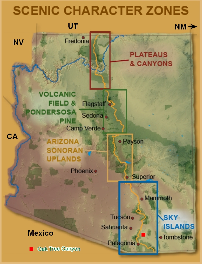
The Arizona Trail was designated a National Scenic Trail by Congress in 2009 and is administered by the U.S. Forest Service. Other partners in the management and protection of the trail include the Bureau of Land Management, the National Park Service, Arizona State Parks, the Arizona Trail Association, and several counties and municipalities. The 12 natural biotic communities found along the AZT support more than 4,000 plant species. This creates an unparalleled opportunity to enjoy and study Arizona’s plant life. To aid in the description of its scenery, the AZT has been divided into four general regions based upon scenic character zones.
Source: US Forest Service

Quite the change from the low desert with 1000s of Saguaro, prickly peak and cholla. I love the Oak savannas with the rolling hills.


Betsy thought this old oak skeleton look just like an Ent plodding across the landscape. I had to agree.
Let's walk with the Ents for a bit, shall we?

I love those clouds! What a nice change from relentlessly cloud-free and azure skies.
We soon left the low area and started climbing up the winding, single track path to the ridge.

Indiana Beth wasn't kidding about the spectacular views. We continued walking along the ridge line and then started to drop down into the canyon.


I lost track of all the different mountain ranges we could see and wish now I had made note of them.


Here is one of the riders we saw earlier. He was stopped and struggling with the grade and loose stones but finally got going again.

The last shot for the day. We would have kept hiking but there was now nearly continuous, heavy gunfire from several directions, and I at least, was tired of listening to it. So, we did an about face and headed back to the trailhead and then home.
It was a nice little outing with some beautiful scenery.

The AZT is just one of 11 National Scenic Trails. You can find out more about them here: National Scenic Trails - NPS
See you next time...
Mike and Betsy