December 14th 2012
On Thursday stormy weather moved in from the southwest. Along with the rain in the lower elevations it brought cooler temperatures and gusty winds. Some snow accumulated above 5,000 ft.
Friday started out rainy and stayed that way most of the day. I finally got out mid-afternoon for a short stroll up the Pima Canyon Trail to the mouth of the canyon.
Pima Canyon is one of the most scenic canyons in the Santa Catalina Mountain range. Like Ventana Canyon just to the east, the trail access is a narrow right-of-way through private property.
The corridor to Ventana Canyon is flanked on one side by condos and the other by a ranch. The Pima Canyon access cuts through "estates" complete with southwest style McMansions.

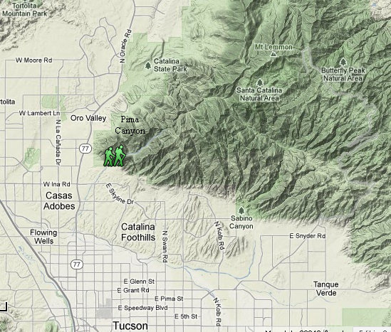
The Big Picture with Pima Canyon marked.

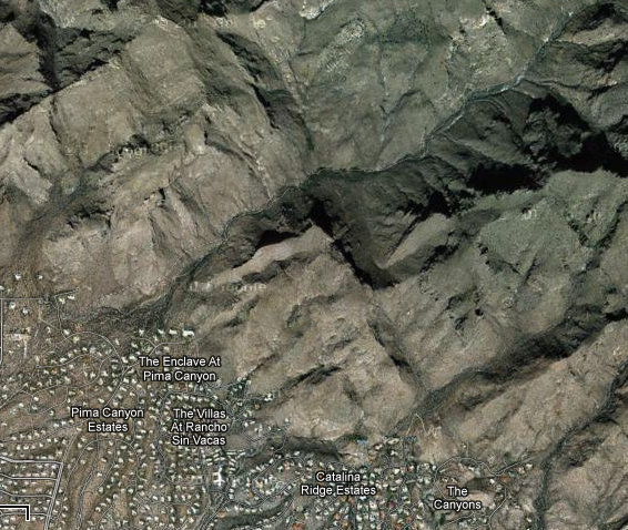
Satellite view of the Pima Canyon area. Houses are built as close to the wilderness boundary as possible.

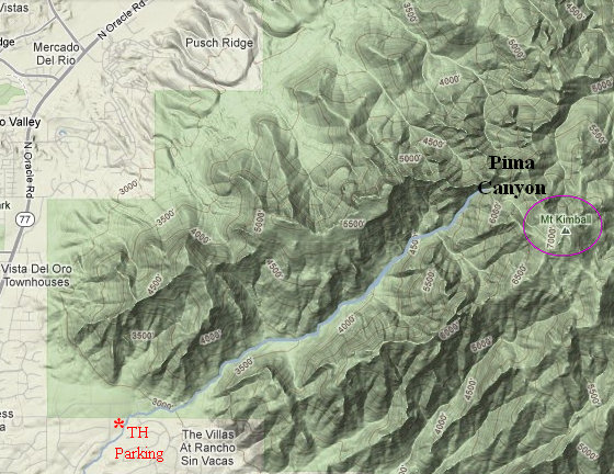
A closer look at the Canyon. Two popular hikes are to an old, filled in dam with matates nearby. Another popular trail is to the summit of Mt. Kimball which at 7258 ft is one of the highest peaks along the southern front of the Santa Catalina Mountains.
Pima Canyon is a major canyon located in the Santa Catalina Mountains, north of Catalina Foothills and Tucson, Arizona, USA. Pusch Ridge forms the northwestern cliffs of Pima Canyon, dramatically rising from Pima Creek on the canyon floor. Pima Canyon varies greatly in elevation, from 2,900 feet (880 m) above sea level at Pima Creek to 6,350 feet (1,940 m) at Pima Saddle. Mount Kimball is the highest peak in the vicinity of the canyon.
Source: WikiPedia
Click on the photos below for a larger image.

This is looking up towards the canyon throught the trail corridor. The house seen here is typical of the style and size which line the wilderness boudary.

The trail climbs gradually up toward the canyon and there are many great views to be had. This is looking to the east along the Cantalina foothills.


The rececent rains had perked up the ferns and Spikemoss.
The fern may be Standley's Cloak Fern (Notholaena standleyi).
The spikemoss is mostly likely Arizona Spike Moss (Selaginella arizonica). This plant is very common in the mountains and forms large, dense mats. When the weather is dry is shrivels up and looks crispy and dead. But with a little moisture it perks back up. This is the reason it is sometimes referred to as the "Resurection Moss".
Arizona Spike Moss is not a true moss but a fern ally. The most fundamental difference between the two is true mosses move water from cell to cell throughout the plant. The Arizona Spike Moss has a vascular bundle through which it transfers water to all parts of the plant.

I contacted Lorena B. Moore who has the site Arizona Xerophytic Ferns: Identification Guide.
She had this to say about the fern photo above.
The fern is Astrolepis sinuata, the largest Astrolepis species and the only one with leaflets that consistently have six or more well-developed lobes. It's probably the most widely distributed desert fern in this area in terms of elevation and habitat preference.
Source: Arizona Xerophytic Ferns: Identification Guide by Lorena B. Moore

More nice views up towards Pima Canyon.


If you click on this image you can see the snow in the upper reaches of the canyon.

On the way back from my walk the clouds, rain and sun were really stirring up the pot.


Just as I got back to the parking area the clouds opened up and here are the results.

'Till next time...