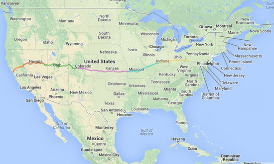
Click for a closer look at the route.
16 August 2014 => Greetings from Brazil!

I never thought I would get to Brazil, but I finally made it.
This is the first stop on my ten day meander out to San Francisco where I will meet Betsy. Betsy is smart. She is flying out. When she arrives we will spend 3 days in The City and then start the drive home. But I am getting ahead of myself. Why am I in Brazil!?
It's the Knerr Factor. That is why I am here. You see, when I married Betsy I got a lot more than I bargained for. A lot more! Lucky for me that is a good thing. Betsy's sister Charlotte had two sons. They got married. They had kids. A lot of kids! And I am now here to visit son # 2 Matt, his wife Amanda, and kids Braeden, Mattison, Ehren and Addie in their new country estate in Brazil. They used to live in the mountains of Pennsylvania. Now they live in Flatlandia. However this neck of the woods is nicely treed and very lush. Not just endless corn and soybean fields. But, Brazil? WikiPedia explains:
In the 1840s, the owners of the farm which would later originate the city of Brazil decided to name their farm after the country of Brazil, because that country was often the subject of news at the time. The city was founded in 1866 under the name of that farm. As of now, Brazil is a part of the Terre Haute Metropolitan Statistical Area. Clay county, which was formed in 1825, originally had Bowling Green as its county seat; the county seat was relocated to Brazil in 1876, following the city's incredible development.
The Chafariz dos Contos (from "contos de réis", a former Brazilian currency) was given by the country of Brazil as a gift to the city, as a symbol of friendship, and was assembled in Forest Park in 1956. It is a replica of the original fountain located in Ouro Preto, Minas Gerais State Brazil, built in 1745.
In 2010, Brazil gained national attention for having accepted money from Kentucky Fried Chicken for the rights to display the KFC and Fiery Grilled Wings logos on city fire hydrants.
Source: WikiPedia
BTW - Son # 1 Scott lives in Laramie, Wyoming with wife Jen and kids Parker, Claire and Liam. I visited them also. But it was a while ago. I had a great time there and here are the pictures to prove it.
Ok. Back to Brazil. On my way here from Morgantown I stopped and took a few snaps. Here is what I saw.

The Clay County Courthouse. Built in 1876. The columns are about 40' tall.

Just in case...


The Annunciation Catholic Church.

All the stone had a spray over of some kinda stucco. The effect was quite phony looking.

Here is the Chafariz dos Contos mentioned in the WikiPedia article above.


I took this grab shot from the window of the van while making the turn at the traffic light. It is the old post office which is now a museum.

This is the Carnegie Library on Walnut Street.
A Carnegie library is a library built with money donated by Scottish-American businessman and philanthropist Andrew Carnegie. A total of 2,509 Carnegie libraries were built between 1883 and 1929, including some belonging to public and university library systems. 1,689 were built in the United States, 660 in Britain and Ireland, 125 in Canada, and others in Australia, New Zealand, Serbia, the Caribbean, Mauritius and Fiji.
Source: WikiPedia

"Free for the People"

When the library was renovated an addition was built.


It's not just for books anymore.

This old wreck was directly across from the library. What a shame...

Yet another fine old church. I saw several others but took no photos.


Just town the street stands this Italianate style Masonic Temple.

This I did not expect to see. It was on the way to the Knerrs. Some people...
Tomorrow morning it will be good-bye Brazil and hello...?
17 August 2014 => Brazil IN to Yates Center KS

The second day of this trip west did not go exactly as planned.
I was up at 6:00 and shortly afterward Matt was up and about. Amanda, God bless her, pulled herself out of bed as well. She had had a long day and I was in bed before she even arrived home from work. So, I appreciated the fact she got up to see me off.
By 7:00 it was still pouring rain. I said my good-byes to Matt and Amanda and dashed to the van. I hopped in, turned the key and - nothing. Yes, I had done it again! I had left the key in the ignition and battery was dead.
I dashed back and to the house and in no time Matt was next to the van with the Suburban and a set of jumper cables and I was soon on my way.
On my way to the interstate I somehow made a wrong turn and ended up at the back door of the Terre Haute airport. I pulled off into a construction area and while consulting the map (which was no help at all) I go several suspicious looks from the people using this service entrance to the airport.
Clueless as to which way to go I flagged down the next person who made the turn into the service area and she put me on the right path. And, before I new it I had crossed the border into Illinois and was on my way.
The start of this drive through Illinois and Missouri was a repeat of when Betsy and I came through in April - rainy, misty, and foggy with lots of areas down to one lane for construction. Definitely cut my average speed down.
Around 10:30 I made it to St Louis. (Buzz, Buzz, Buzz goes the buzzer...). At this time on a Sunday morning the traffic was light for which I was thankful. When Betsy and I came through in April it was at the AM rush hour and the roads were all like parking lots. Ugh...

I grabbed a few pics of the Arch as I passed through.


The Gateway Arch is a 630-foot-high (192 m) monument in St. Louis, in the U.S. state of Missouri. Clad in stainless steel and built in the form of a flattened catenary arch, it is the tallest man-made monument in the Western Hemisphere, Missouri's tallest accessible building, and the world's tallest arch. Built as a monument to the westward expansion of the United States,it is the centerpiece of the Jefferson National Expansion Memorial and has become an internationally famous symbol of St. Louis.
The arch sits at the site of St. Louis' founding on the west bank of the Mississippi River.
The Gateway Arch was designed by Finnish-American architect Eero Saarinen and German-American structural engineer Hannskarl Bandel in 1947. Construction began on February 12, 1963, and was completed on October 28, 1965, at a total cost of US$13 million ($97,300,000 in 2014). The monument opened to the public on June 10, 1967.
Source: WikiPedia
Once I got out of the St Louis area the drive got pretty nice. I travelled through lush dense forests with rolling hills and some nice rivers. I would love spend more time here.
But, I must push on...

I passed through Bolivar in western MO and grabbed this shot out the window. Some of these court houses are unbelievable!
Bolivar began as a settlement around Keeling Spring, with the majority of settlers being from Hardeman County, Tennessee.
Bolivar experienced growth in 1884 when the St. Louis–San Francisco Railway was extended to that point.
The name Bolivar was proposed by John Polk Campbell and his brothers William St. Clair and Ezekiel Madison. The name is after Bolivar, Tennessee where their grandfather and Continental Army Colonel Ezekiel Polk had lived. In the 1830s, both Polk and Bolivar were names locally associated with liberation. As such, Bolivar, Missouri is an indirect namesake of Simón Bolívar.
Source: WikiPedia
About 60 miles west of Bolivar is Nevada MO. Originally I planned to stay here but I arrived earlier than anticipated so I did a walk about instead and continued westward.

Click for the big picture.

I think I must have been tipsy when I took this shot. It is in the downtown area of Nevada. It is the old sheriffs office. Is is now closed up. Nice building.

Detail shot of the entrance to the above building. I really must learn to hold the camera straight!

Yet another gorgeous courthouse!
Vernon County suffered considerable damage during the American Civil War. The courthouse was burned by Union Army soldiers on May 23, 1863, along with the entire town of Nevada. The present courthouse dates to 1907. Vernon County was one of four Missouri counties that were completely depopulated by Union General Thomas Ewing's notorious General Order No. 11 (1863). Most of the inhabitants would not be allowed to return to their homes until after the Civil War ended in May 1865.
Source: WikiPedia


This building alone makes it worth the time and effort to visit Nevada.

This corner stone for the Vernon County Courthouse gives us a little more info.
I departed Nevada MO and headed east to the small town of Fort Scott. This is just across the state line in Kansas and is due west of Nevada.
Established and garrisoned by the U.S. Army from 1842–1853, soldiers at Fort Scott assisted with the protection of the Permanent Indian Frontier. After the army abandoned the fort in 1853, the buildings were purchased by local settlers at a government auction in 1855. Fort Scott was laid out as a town in 1857.
Source: WikiPedia

This was one of the first buildings I saw in Fort Scott. When I saw it I wondered if Fern had finally finished the chimney job and had now found a new project.
(Inside joke)

Part of the downtown area is paved with these local bricks.

Fort Scott is a treasure trove of beautiful old buildings. I could easily have spent the day there. Maybe some day I will.

The Moody Building was constructed in 1889. Is is on the National Register of Historic Places.

A look down Main street in Fort Scott.
The Ancient and Accepted Scottish Rite of Freemasonry (the Northern Masonic Jurisdiction in the United States often omits the and, while the English Constitution in the United Kingdom omits the Scottish), commonly known as simply the Scottish Rite, is one of several Rites of Freemasonry. A Rite is a progressive series of degrees conferred by various Masonic organizations or bodies, each of which operates under the control of its own central authority. In the Scottish Rite the central authority is called a Supreme Council.
Source: WikiPedia
This one building spanned half a city block. The far end of the building is a bank.

It is the mission of the Scottish Rite of Freemasonry, SJ, to improve it members and enhance the communities in which they live by teaching and emulating the principles of Brotherly Love, Tolerance, Charity, and Truth while actively embracing high social, moral, and spiritual values including fellowship, compassion, and dedication to God, family and country.
Source: The Scottish Rite Masons of the Southern Jurisdiction

The lighting was poor so this detail shot did not come out that great.


Now here was a real treat! I have not seen one of these moths in many, many years. It is a Hawk Moth or Sphinx Moth. I was transfixed and watched until my neck got sore. Fascinating creatures. We used to see them all the time as kids and knew them well.
Some hawk moths, such as the hummingbird hawk moth or the white-lined sphinx, hover in midair while they feed on nectar from flowers, so are sometimes mistaken for hummingbirds. This hovering capability is only known to have evolved four times in nectar feeders: in hummingbirds, certain bats, hoverflies, and these sphingids (an example of convergent evolution).
Sphingids have been much studied for their flying ability, especially their ability to move rapidly from side to side while hovering, called 'swing-hovering' or 'side-slipping.' This is thought to have evolved to deal with ambush predators that lie in wait in flowers.Sphingids are some of the faster flying insects; some are capable of flying at over 5.3 m/s (12 miles per hour).They have wingspans from 4 to over 10 cm.
Source: WikiPedia

Try as I might I could not get a good shot of it, even with the camera flash on.

This is a crop from the above shot. Not that great, but better than nothing.

Fort Scott has a Carnegie Library as well.


This is the library corner stone. Some one care to explain the "A.L. 5902" to us?
UPATE: CP says:
That's the date in Masonic years. We count from the earliest incarnation of the craft, giving a 4,000-year difference in the digits. "A.L." is "Anno Lux" or "year of light". Masonic cornerstones used to be very common. Less so now, but still one is laid every now and then.

As I said, Fort Scott is a treasure trove of delicious old buildings.

This is what I would call "gaudi-fied". Sheesh!

On the north edge of town I saw this Marsh arch bridge over the Marmaton River. It is on N. National Avenue (Old US 69). It was rehabbed in 2012. Lookin' good!


This is one of three blockhouses which were built at Fort Scott.

One final shot and I was on my way west. My route would take me on across Kansas and into the heart of the prairie.
18 August 2014 => Yates Center KS to Pueblo CO

My overnight in teeny-tiny Yates Center KS was quiet, except for the continuous roar of the undersized AC unit and the 100s of smoke belching tractor trailers.
YC is at the crossroads of Rts 54 and 765 and when I arrived there it was non stop truck traffic through the intersection which is conveniently located right next to the motel, actually both motels. YC is a 2 motel town.
I chose the Star Motel, why I am not sure. Later I realized that was also the name of one of our favorite places to stay in the UP of Michigan. But unlike the Yooper Star this one was not situated on the scenic north shore of Lake Michigan.
By now it was 4:30 Central, 5:30 Eastern and I had been on the road since 7am. I was looking forward to a cold beer in the hot sun. The YC Star faces due west and the sun on the hotel was so searingly hot even the white door to the room was almost too hot to touch. The temp was probably in the low 90s.
I sat in the baking sun for two beers. It felt good - for a while, and then I was forced into the shabby little room which was only marginally cooler. The room had one of those $59 Haier AC units sold at WalMarts and it was obviously not up to the job of heating what was essentially a west facing oven.
My dinner options in YC were somewhat limited. It was Pizza Hut, Subway or beer and Doritos. The latter was mighty temptin' but I did the right thing and went to Subway.
I spent the evening processing photos and webulizing and was in bed at my usual time - 9pm.
The next morning I was up and on the road at 6:45 and before I knew it I was in the peace and quiet of the Kansas Prairie.
This part of Kansas is know as the Flint Hills. And the lush, rolling hills made for very pleasant driving. Especially when lit up by the early morning sun.

I so wanted to get a few good photos of this gorgeous landscape but I could not manage it.

What does no come through here is the series of low rolling hills and the pockets of ground fog and mist hovering over the meandering creeks. It was quite beautiful.
The Flint Hills historically known as Bluestem Pastures or Blue Stem Hills, is a region in southeast Kansas named for the abundant residual flint eroded from the bedrock that lies near or at the surface. The region includes a band of hills in eastern Kansas stretching into north-central Oklahoma, extending from Marshall and Washington counties in the north to Cowley County, Kansas and Kay and Osage counties in Oklahoma in the south, to Geary and Shawnee counties west to east.
Source: WikiPedia
Check out these photos of the Flint Hills by James Nedresky. They show what the Flint Hills are really like.
I continued west on US 54, jogged south on 99 and then right onto US 400. It was near here I spotted the Piedmont Cemetery.

I have seen more than one little cemetery like this on the back roads I usually travel. I always think about staying overnight in one these deathly quiet places. It would sure be nicer than places like the Star Motel in Yates Center.

I wandered around for about an hour taking pictures here and there and generally enjoying the early morning quiet.


I am sure there is an official name for cemetery buildings like these. This one had a small table with a register and a fireplace that might help take the chill off on a windy Kansas winter day.

I love these rubble walls. Some knowledge of the local geology would have come in handy at this point.

All the comforts of home...

One year shy of forty years old.

The hand made wooden cross on this humble grave mound said simply "Happy Birthday".

Phoebe Copeland. Death came knockin' at the age of 43 years, 7 months and 12 days.

Lorraine has been without her Bill for 10 years now.

This I did not understand. Three sisters. Were they born or did they die in '48, '53 and '58? And the biblical reference of "1 COR 15:34"?
"Wake up from your drunken stupor, as is right, and do not go on sinning. For some have no knowledge of God. I say this to your shame."
Very strange.
I then said farewell to my new friends and I was soon rolling through Wichita and then back out into rural Kansas.
The rest of the drive to Pueblo was not so scenic, at least to my eyes. It was much more open, flat and mostly ag fields.
It was near Dodge City I picked up US Rt 50. This is the road I will be on for the rest of the drive to San Francisco.
I stopped in Lamar CO for something to eat. It was a blistering 102 degrees under cloudless skies. But: "It's a dry heat!".

This part of Kansas and eastern Colorado is in the Arkansas River Valley (Ark Valley to the locals). The land is fertile and the water plentiful. I saw many, many acres of melon crops and lots of road side farm stands.
There were also some interesting sounding (and looking) small towns in this part of eastern Colorado. Places like Las Animas, La Junta and Rocky Ford. Some day...
My bed tonight at the Motel 6 in Pueblo could be in Anywhere, America. But, it has a pool and the AC is a bit quieter and at 44 bucks it is nicely priced.
Next stop: Grand Junction CO.
19 August 2014 => Pueblo CO to Grand Junction Co.

In 1982 Betsy and I were in this area on our 7 week Honeymoon and again in 1997. But I have to say driving it today was like the first time again. The scenery was amazing, especially when contrasted with the drive across Missouri and Kansas.
The photos below, shot mostly through the windshield will give you an idea of what the drive was like today.

Just west of Pueblo. The clouds made for some interesting shots.

This is outside of the town of Canon just to the west of Pueblo CO. I was trying to get a shot of the distant mountains. Note the firewood. Apparently it is a big business here as many places had huge stock piles of it.
Canon's claim to fame is the Royal Gorge Bridge which is a huge tourist trap. Much of it burned up in 2013.

I drove the Royal Gorge road through the burned out area and there were lots of wild flowers filling in the blanks.


I should know this one as I have seen it many times before. But, memory fails me.

I was glad my eyes found this before my feet did!

This burned out lone sentry stands watch.


I don't know if the fire closed this place or not. It is on the road into Royal Gorge. The realty info listed it as 89 acres and assorted buildings for 2.2 million dollars. More...

I continued west on US 50 into Bighorn Sheep Canyon. An amazing drive.

US 50 follows the Arkansas River which is a very popular fly fishing and white water rafting stream.

I stopped at some of the pull out for a few quick snaps.

Where is a geologist when you need one!!??

If you look closely you can see the teeny tiny car at the base of the huge rock.

Betsy and I passed this way in May of 1982. At that time most of the parking area was covered with huge piles of snow.

More lovelies growing at the summit.

On the west of the pass it started to rain. This continued on and off all the way to Grand Junction.

The big sliding board.

This was in Curecanti NRA. It is not to far from The Black Canyon of the Gunnison where Betsy and I hike on our Honeymoon.

The Dillon Pinnacles.
This was the last shot of the day. The rest of the drive to Grand Junction was not quite so impressive so I let the camera have a rest.
To night I will be in another Motel 6 at 49 bucks. It is very quiet here right now and I hope it stays that way.
Next stop: Ely NV.
20 August 2014 =>Grand Junction Co to Ely NV

My hoped for quiet night at the Motel 6 did not happen. There were people in and out all night and kids partying in the parking lot. I didn't get much sleep, that's for sure.
My driving route the previous day had be on US 50 and today it still will be. But, starting at Grand Junction Rt 50 and I-70 share the same corridor. I would leave I-70 later in the day and hop back onto US 50 and then on into the vast openess of central Nevada. This section of US 50 across Nevada is often referred to as the lonliest road in America.
If you drive it, you will understand why.
Charles Kuralt once said: "Thanks to the Interstate Highway System, it is now possible to travel from coast to coast without seeing anything." But that would not be the case on this day.
A caveat: All but a few of the photos were shot through the windsheild and side window glass. If they look blurry, that is why.
One thing which really helped with the pics was driving west and having the mid morning sun light every thing up. It really made a differnce. So, if you drive this section the optimal time is early/mid morning going west.

Just west of Grand Junction CO


Good-bye Colorado - hello Utah!

The previous day's stormy weather left some nice clouds hanging around.


The wide open spaces.


I soon came into view of a rest stop which is about 77 miles west of Grand Junction so I stopped to check out the views from the ground instead of the car. This telephoto shot shows some other folks who stopped.

Prairie dogs (genus Cynomys) are burrowing rodents native to the grasslands of North America. The five different species of prairie dogs are: black-tailed, white-tailed, Gunnison's, Utah, and Mexican prairie dogs. They are a type of ground squirrel, found in the United States, Canada and Mexico.
In Mexico, prairie dogs are found primarily in the northern states, which lie at the southern end of the Great Plains: northeastern Sonora, north and northeastern Chihuahua, northern Coahuila, northern Nuevo Le�n, and northern Tamaulipas. In the US, they range primarily to the west of the Mississippi River, though they have also been introduced in a few eastern locales. They are herbivorous.

This critter was obviously used to being fed and did not seem to concerned as I moved in closer.

Note the eyes on the side of he head. A sure indication the Praire dog is food for the local predators.

This is Harriman's Narrow Leaf Yucca (Yucca harrimaniae). It is native to the Four Corners area and Nevada.

The species name honors the Harrimans, railroad owners and sponsors of the Harriman Alaska Expedition. The plant was specifically named for Mrs. Harriman by the botanist and Missouri Botanical Garden Director, William Trelease (1857-1945) who was on the Harriman Expedition to Alaska. After the Expedition, the train carrying trip participants stalled in Helper, Utah. Trelease passed the time botanizing and discovered Yucca harrimaniae. (More biographical information about the Harrimans.)

I departed the rest area and continues west. The scenery was stunning and constantly changing.


WOW!!!

The brown sign says: "Gobling Valley State Park". This is the place where two (now former)Boy Scout leaders toppled one of the ancient rock formations (goblin).
A group of Boy Scout leaders could be in serious trouble after they posted video online of one of them toppling a rock formation at Goblin Valley State Park in Utah.
The rocks, which resemble mushrooms, date back to the Jurassic Period, about 145 to 170 million years ago. They are, to say the least, a precious reminder of the Earth's history.
In the video, two men are seen cheering on their friend, who is trying to topple one of the formations. After he pushes off another rock, the "goblin" tumbles and then the men high-five.
Source: WikiPedia
YouTube culture never ceases to amaze me. People are so desperate to be in the spotlight they will even post a video of themselves commiting a crime.

I have to say I have never gotten windsheild shots like these before. The scenery was non-stop stunning mile after mile.

The Squeeze?

photo0000132.jpg

I got boxed in on one of the longer grades.


More jaw dropping scenery. It just went on and on.


For interstate driving one could not ask for much more than this. Whew!

Now it was going to be down, down, down from and elevation of nearly 6000' to to around 4600' when I reach the Salina, Fillmore, Delta valley area.


This exit brought back memeories of two visit two Fish Lake National Forest. The first visit was with Ethel Moffatt-Nofsinger (deceaced) in the mid 1970s. Then in 1982 Betsy and I
http://www.fs.usda.gov/recarea/fishlake/recreation/recarea/?recid=12165&actid=62
photo0000146.jpg

photo0000147.jpg

photo0000148.jpg

This is the last shot on I-70. Shortly after this I got off at exit 56 to Salina. At this point I-70 heads south and US 50 continues on west.

This veteran's plaza in Salina was right next to where I gassed up so I grabbed a shot.
"The first permanent settlers (about 30 families) moved into the area in 1864 at the direction of leaders of The Church of Jesus Christ of Latter-day Saints. They found abundant salt deposits nearby so they named the area "Salina".
In 1866 troubles with Indians who used the area as their hunting ground (the Black Hawk War (Utah)) forced the white settlers to retreat to the Manti area. They returned to Salina in 1871, organized a militia, and constructed a fort and buildings for a school and a church. At that time they discovered coal deposits in "almost inexhaustible quantities" in the canyon east of the settlement."
Source: WikiPedia

photo0000151.jpg

photo0000152.jpg

photo0000153.jpg

photo0000154.jpg

photo0000155.jpg

photo0000156.jpg

photo0000157.jpg

photo0000158.jpg

photo0000159.jpg

photo0000160.jpg

photo0000161.jpg

weather.jpg
~~~~~
~~~~~~~~~~~~~~~~~~~~~~~~
21 August 2014 =>Cave Lake State Park - Ely NV
In 2011 I took another Road Trip to San Francisco. That route also brought me through Ely where, like this trip I stayed two nights and hiked in nearby Cave Lake State Park.
That is where I was today. Not much has changed at the Park. So, I decided to give my shutter finger a break and rely on the photos I took from that trip in 2011. I mean, HEY! - whey reinvent the wheel?
Now, let's step back in timeto August of 2011:
Cave Lake State Park - Ely NV
~~~~~~~~~~~~~~~~~~~~~~~~
21 August 2014 =>Ward Charcoal Ovens - Ely NV
After my hike at the Cave Lake State Park I decided to check out another state park just down the road. It is Ward Charcoal Ovens State Historic Park. I had noticed the road sign before but had not yet been there. Now seemed like a good time - who knows when I might be back this way?
The basin near Ward Charcoal Ovens was a major stopover for settlers who used Cave Valley road to travel from Pioche, Nevada, to the nearby railroad town of Toano (1870–1876). Silver ore was discovered here in 1872 when freighters were looking for oxen that were grazing in the Willow Creek Basin area.
The Ward Mining District, located two miles north of the park, was then developed. Small claim mining continued in this area for several years. In April 1875, the Martin & White Company from San Francisco invested money to extract silver ore, bought up several small claims and built smelters (furnaces for melting ores).Source: Nevada State Parks

On my way down to the Ward Charcoal Ovens I grabbed a few snaps of the expansive Steptoe Valley.


I did not know what to expect and I was quite amazed at what I saw.

A look out from one of the ovens.
The Ward Charcoal Ovens served diverse purposes after their function as charcoal ovens ended. They sheltered stockmen and prospectors during foul weather and had a reputation as a hideout for stagecoach bandits.
Source: Nevada State Parks

This is the main door through which most of the wood was loaded and the charcoal removed and then bagged up.

The reddish-orange blotches is a lichen which is growing on the north side of the oven. Not the row of square openings at the bottom. This is one of the rows of vents which allowed a controlled amount of air to enter the furnace.

The tertiary volcanic and quartz latite tuff from which the ovens are made, the quality construction and the dry climate have all helped to preserve these in a near pristine state.
The charcoaling process:
Wood was cut into 5-foot to 6-foot lengths and stacked inside the ovens vertically using the lower door. The first floor of the oven was filled leaving an open space in the center to serve as a chimney. The wood was then loaded up a ramp and through the upper door, which looks like a window, in the same fashion.The loaded oven was ignited and the metal door was cemented shut. The vents were used to adjust the air drafts to suffocate the fire just enough to produce charcoal. Burners gauged the charcoaling process by the color of the smoke.
When the charcoaling was completed, in about 10 days, all air vents were closed and the fire died out. The charcoal was then cooled using water through the chimney. The oven was emptied loading the charcoal into bushel-size burlap sacks.
Source: WikiPedia


The ovens were built by itinerant Italian masons who specialized in the ovens, who were known as carbonari.

This is the upper door where more wood was loaded until the oven was full.

A look out the upper door.

It is hard to imagine the kind of life these people led. Everything was manual labor from the quarrying and cutting of the stone, the building of the wooden scaffold and the laying of the stone. And think of all the tree felling hauling and cutting of the wood bolts. I wonder what the average life span wasis And, worst of all - no Internet!

This butte is directly behind the ovens. I thought it made a pretty picture.

And then it was back to home sweet home where I settled back in with a the mix of gamblers, outdoor rec types, itinerant carpet layers and assorted poor white trash.
Next stop: Carson City NV/Lake Tahoe.
~~~~~~~~~~~~~~~~~~~~~~~~
24 August 2014 =>San Francisco: Arrival!!
Well, I made it! After 7 days and 2964 miles I arrived in San Francisco at about 11:00 am Pacific time.
I was able to navigate from the Oakland-Bay Bridge to the Outer Sunset Neighborhood of San Francisco with no problems. I went directly to Ocean Beach which is 3.5 miles of sand beach and dunes on The City's southern doorstep. I went for a short stroll on the beach prior to checking in to the rental room marked on the map below.

After checking in I walked down to the N Judah street car stop. I got on the inbound, and took it up to 16th Avenue. I then walked up 16th to the Hidden Park tiled steps and then walked around upper 16th to the Moraga Tile steps and then on up to Grand View Park. The view was spectacular. It was sunny and not a cloud in sky. More on this later.
I then took the Encinal Walk down to the east side of Moraga Street, then down to 9th and Judah. It was busy, busy, busy! There were lots of people out enjoying this sunny Sunday.
Here I caught the 44 O'Shaughnessy bus up to California Street. I then caught the 1 California bus and took it outbound to 32nd Avenue where I got off.
I then walked down 32nd to El Camino del Mar where I picked up the Coastal/Land's End Trail at Eagle's Point.
This what I saw:

The Golden Gate Bridge with Baker Beach to the right as seen from Eagle's Point.
This seemed the perfect spot to check in with Betsy so I sat in the sun and gave her a call to let her know I had arrived and all was well. I then continued on down the trail stopping occasionally to take in the views.

Two love birds enjoy the view. Soon this will be Betsy and me. Sigh...
I continued on the down the trail. There was a steady stream of walkers and runners in both directions. When I arrived at the NPS Lands End Lookout and Visitors Center it too was busy, busy, busy!
Here is a view of Ocean Beach from near the lookout:


The water is a bit on the chilly side but that does not deter the wet suit clad surfers and the occasional hardy swimmer. Most folks were just out enjoying the sun, playing volley ball, having cooking-outs and getting warmed next to camp fires. Not a bad way to spend a Sunday afternoon.
I then walked down the beachfront promenade to Lincoln Way, turned left and then hung an immediate right and walked south on inner Great Highway to Noriega Street where I then turned left and walked up to 45th Avenue where our room is.
By now it was about 6:30 and I was pooped! I spent some time reoganizing our room since earlier I had pretty much just dropped everything and was then back out the door again.
I then chilled with some brews and Chinese food and that was the end of my first day here in San Fran.
Betsy arrives on Tuesday at noon and I am glad of it!
More later...