Mike Breiding's Epic Road Trips: September 2022
California
The ERT Begins: Tucson to Buttonwillow
Beautiful Basin and Range, Tehachapi Loop and Cesar Chavez
Tucson to Buttonwillow
Beautiful Basin and Range, Tehachapi Loop and Cesar Chavez
On 25 September 2022 I sent out this: "Well, here we go! Tomorrow, before the crack of dawn we will depart Tucson."
Today's date? 21 October 2022. Will someone explain to me how a month has slipped away since I announced our impending California and Oregon Road Trip?
In the intro for this ERT I mentioned it seemed unlikely I would be able to write up trip reports while on the road and indeed that did not happen. Although I did make an attempt, only to find out I could not connect to hotel networks and thus could not get anything up loaded. So, I gave up on that idea (sigh of relief).
Now, a month after the fact I must play catch up. This is always difficult to do. The details fade and become mixed up and the enthusiasm wanes. And for me the trip disappointments always loom large and often taint the experience and kill the desire to write.
But I was bound and determined to get a little scribbling done so let us begin.
On 26 September 2022 we did indeed leave at the crack of 6:00. We had a long day ahead of us - 650 miles with two stops along the way.
As usual when driving northwest toward California we took the "Phoenix By-Pass" which jogs west to Gila Bend and then north up to I-10.

The "Phoenix By-Pass" route
Gila Bend is named for a bend in the Gila River. How clever. Of course prior to that it was ranch land take from the locals who are sometimes called "indigenous peoples".
From 1857, this place was named "Gila Ranch" and was a stagecoach water and camping stop on the San Antonio-San Diego Mail Line. In 1858. as "Gila Ranch Station", it was a stage station on the more famous Butterfield Overland Mail route to California. Gila Bend Station was located 17 miles (27 km) east of Murderer's Grave Station and 40 miles (64 km) west of Maricopa Wells Station across the waterless Forty Mile Desert.
Once safely out of the reach of Phoenix we headed west to New Hope and then picked up Vicksburg Road which runs due north to the town of Vicksburg where we turned northwest on SR 72 to SR 95 and then on to SR 62 at Parker where we crossed the Colorado River into California. Then it was US 95 and up to I-40 at Needles. Circuitous. But worth it to completely avoid the Phoenix area.

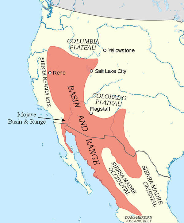
California Geomorphic Provinces - Source: http://mojavedesert.net/
Shown in the lower right portion of this map is the Mojave Desert. This section of I-40 is just to the south of the Mojave National Preserve. Generally interstate driving is nothing to get excited about. But this section of I-40 goes through some of the most beautiful Basin and Range scenery and we found it awe inspiring. At least to Betsy and me it was. I am sure others (most) might see it as a desolate wasteland unfit for humans.
The desert is not a wasteland. But if you let people make uninformed decisions about what to do with all this “empty, barren” space, you’ll get some crazy ideas. In the 1960s, the US Government planned to detonate 23 nuclear bombs in the central Mojave Desert to excavate a path through the Bristol Mountains and make way for Interstate 40 and a railroad.
Source: Desert Advocate
No doubt this is not the craziest idea to come out of Washington but I am sure it is right there at the top.
Since the area was not nuked Betsy and I were able to enjoy mile after mile of gorgeous Mojave Basin and Range scenery.
The Mojave Basin and Range is a region encompassing a series of Warm Deserts stretching from interior southern California through southern Nevada and into northwestern Utah. It is the northernmost portion of the warm deserts in North America.
This region consists of broad basins and scattered mountains that tend to be lower-elevation and warmer than the Central Basin and Range to the north.Source: bplant.org
 Source: WikiPedia
The area of the Mojave desert Betsy and I were now travelling though is known as the "Lavic Lake volcanic field".
The Lavic Lake volcanic field is a volcanic field with extinct cinder cones in the Mojave Desert, in San Bernardino County, California, United States, at 762 m (2,500 ft) elevation. Its cones lie directly alongside historic Route 66 and modern Interstate 40, between Barstow to the west and Ludlow 10 miles to the east.
Source: WikiPedia
At one point we noticed an area with black basalt lava flows on the north side of I-40. It was quite a dramatic landscape.
But, no photos were taken this time around as we have many miles to go before we sleep.

Our route along I-40 west of the Mojave Basin and Range would take us by the town of Newberry Springs. Some of you may remember that town from the 1987 movie "Bagdad Cafe" which was just off beat enough to make a nice change from run of the mill movies showing at the local cineplex.

In 1987, the motion picture Bagdad Café was filmed in the area and the truck-stop restaurant featured in the film still stands. The motel in the film has crumbled, but its foundation remains. The cafe is now frequented by locals and visitors, but mostly by French and German tourists who are fans of the film. Prior to the film the restaurant had a different name. The Bagdad cafe was in nearby Bagdad / Chase Mine area. Gold from the Chase Mine helped establish the bank of the same name, Chase Manhattan Bank.
Source: WikiPedia
20 miles west of Newberry Springs is Barstow and the intersections of I-10, I-15 and SR 58. It was the latter which would take us to our first stop of the day: The Tehachapi Loop in the Tehachapi Mountains which are about 100 miles west of Barstow and 30 miles east of Bakersfield.
The Tehachapi Loop:
I think it is safe to say neither Betsy or I are railroad buffs except as it relates to Rail-Trail conversions.
Enter Chuck Coole.
I first met Chuck in the early 90s when he got me involved in a trail mapping project in Davis WV. Chuck had experience working with GIS and I was a newbie so we had a common interest established.
From May 1992 to September 1999 Chuck was a Program Analyst for the USDA Forest Service, Northeastern Area, State and Private Forestry, Wood In Transportation Program. This included work on pedestrian timber bridges in the Morgantown parks. At the time I was working for the City of Morgantown on trail construction in the city parks. Another shared interest with Chuck which was trail related.
Between October 2002 to May 2007 Chuck was the Forest Website Manager for the Sequoia National Forest "The Forest Website Manager position is a member of the Public Affairs Office and produces and maintains the Forest's presence on the Internet and Intranet to meet Forest internal and external communication goals."
While Chuck was the Sequoia Website Manager he worked at the Forest Service Supervisor's office in Porterville and lived in Springville renting a studio house from his landlady Joan. Joan had extensive knowledge of the botany of the area and knew the Sequoia intimately. She shared that info with Chuck and that combined with his own exploration of the area made Chuck what I call a "local expert". So, when one of my road trips took me to the area in and around the Sequoia National Forest Chuck provided me with all kinds of info on places to see in the area.
From June 1970 to April 1980 Chuck worked for CSX as a train operator at several train control towers on the Monongah Division and in several clerical positions, including car distribution, tonnage clerk, field caller, and yard clerk.
In an email Chuck wrote: "If you look up D Tower Grafton you'll find a lot of sites about it. It's the most famous place where I worked. It could be a very busy place working with the yardmaster, and three train dispatchers." And this as well "Remembering where I worked: D Tower, Berryburg Junction, Gastion Junction, GN Tower. MD Tower."
When I mentioned this current trip to Chuck the information started flowing again and one of the places Chuck suggested we check out was the Tehachapi Loop which as mentioned above is between Bakersfield and Barstow.
I started reading up on the Loop and was intrigued enough to check it out.
The Tehachapi Loop is a 3,779 feet (0.72 mi; 1.15 km) long spiral, or helix, on the Union Pacific Railroad Mojave Subdivision through Tehachapi Pass, of the Tehachapi Mountains in Kern County, south-central California. The line connects Bakersfield and the San Joaquin Valley to Mojave in the Mojave Desert.
Rising at a steady two-percent grade, the track gains 77 feet (23 m) in elevation and makes a 1,210-foot (370 m) diameter circle. Any train that is at least 3,800 feet (1,162 m) (approx. 56 60’(67'11") box cars) long passes over itself going around the loop. At the bottom of the loop, the track passes through Tunnel 9, the ninth tunnel built as the railroad was extended from Bakersfield.
Source: WikiPedia
The Loop is in the Tehachapi Mountains which top out at nearly 8000'. Contrast that to the elevation of Barstow at 2100' and Bakersfield at 404'. Getting freight trains up and over those mountains took more than engines, it took some special track construction in the form of a loop to get them up and over the hump and down to Bakersfield.

The above map was made using the Google Earth App. I added the pink line as a track and then had GE run an elevation profile on it. This helped me see in a graphical way the differences in the elevations.

The above map more or less shows the route of the Union Pacific Railroad which climbs and crosses the Tehachapi Mountains.
It also shows the Tehachapi Mountains are a Transverse Range which means the range trends west to east rather than north to south like the majority of the mountain ranges in California. This has the effect of being a barrier between the Mojave Desert to the south and the mountains and grasslands to the north.
77,000 acres of the Tehachapi Mts are now included in a new Nature Conservancy preserve. The Frank and Joan Randall preserve which has been 20 years in the making was made possible by their donation of 50 million dollars.
Read more about the preserve here: A New Preserve Secures California’s Crossroad.

Here we are at The Loop. I have to admit I was disappointed. The view from the observation deck just doesn't show the size of the spiral.
Thanks goodness for WikiPedia!

This aerial photo by Keavon Chambers of WikiPedia clearly shows why the loop is named The Loop!
But wait - it gets better!

This shot by David Brossard shows the train crossing itself.
So, now I have not only seen a river that crosses itself, I have seen a train do it as well.

California Historical Landmark
Tehachapi Loop
From this spot may be seen a portion of the world-renowned "loop". It was completed in 1876 under the direction of William Hood, Southern Pacific railroad engineer. In gaining elevation around central hill of loop a 4,000-foot train will cross 77 feet above its rear cars in tunnel below.
Dedicated - October 25, 1953
Marker placed by Kern County Historical Society
Bakersfield parlor no 42 N.S.G.W.
El Tejon parlor no 239 N.D.G.W.
Kern County Museum
Southern Pacific Railroad
State registered landmark No. 506

National Historic
Civil Engineering LandmarkTehachapi Pass Railroad Line
Constructed 1874 - 1876 Commemorated October 1998In front of you is the world famous Tehachapi Loop which is about halfway upgrade to the Tehachapi Pass. This steep line averages 2.2% in gradient in its 28 miles of length. This feat of civil engineering genius was the crowning achievement of civil engineer William Hood of the Southern Pacific Railway Company. It is one of the seven wonders of the railroad world.
The Tehachapi Pass Railroad Line was cut through solid and decomposed granite by up to 3,000 Chinese laborers from Canton China. They used picks, shovels, horse drawn carts and blasting powder. This line, which climbs out of the San Joaquin Valley and through the Tehachapi Mountains had 18 tunnels, 10 bridges and numerous water towers for the old steam locomotives. It was completed in less than 2 years time under the leadership of civil engineer J. B. Harris, Chief of Construction, a remarkable feat.
This line was part of the last and final link of the first railroad line connecting San Francisco to Los Angeles. It was a primary factor in the early growth of the City of Los Angeles and the State of California.
This single track line, essentially unchanged, is still in constant use today, 122 years after its completion. It passes an average of 36 freight trains each day. This attests to the superior job of both engineering and construction done by the two civil engineers and the Chinese laborers. This plaque is dedicated to them.
History and Heritage Committee
Los Angeles Section and Southern San Joaquin Branch
American Society of Civil Engineers

Now we are on our way to our second stop of the day which is just down the hill from the Tehachapi Loop.

The first time I heard the name of Cesar Chavez was in the late 1960s and I most likely heard the name from social activist and family friend Julian Martin.
Chavez was a labor activist who was involved in organizing California farm workers in order to get them better pay, better working and living conditions and better sanitation both in and out of the fields. This is very similar to what had and was happening with coal miners in West Virginia and elsewhere.
At the time there was a strong effort to boycott Delano grapes and we heard a lot about that at 2381 Bush Street where my family and others lived at the time.
Most of the farm workers lived and worked in California's Central Valley.

For comparison - our home state of West Virginia is 24,00 square miles.
The Central Valley is a region known for its agricultural productivity: it provides more than half of the fruits, vegetables, and nuts grown in the United States. More than 7,000,000 acres (28,000 km) of the valley are irrigated via reservoirs and canals. The valley hosts many cities, including the state capital Sacramento; as well as Redding, Chico, Stockton, Modesto, Merced, Fresno, Visalia, and Bakersfield.
Source: WikiPedia
Somebody has to prep the fields, and plant, harvest and pack the crops grown on those 7,000,000 acres. That has traditionally been minorities. In this case mostly Filipinos and Hispanics. They were paid only enough to survive and be there to pick the next crop.
In a effort to lift these workers and their families out of poverty people like Chavez and Itliong worked tirelessly over a period of decades to get fair wages and decent working and living conditions.

Cesar Chavez born Cesario Estrada Chavez (March 31, 1927 – April 23, 1993) was an American labor leader and civil rights activist. Along with Dolores Huerta, he co-founded the National Farm Workers Association (NFWA), which later merged with the Agricultural Workers Organizing Committee (AWOC) to become the United Farm Workers (UFW) labor union. Ideologically, his world-view combined leftist politics with Catholic social teachings.
Source: WikiPedia
Although the Chavez name was usually in the forefront of the media and the Delano Grape Strike it was actually a Filipino-American labor organizer who got things going.
Modesto "Larry" Dulay Itliong(October 25, 1913 – February 1977), also known as "Seven Fingers", was a Filipino-American labor organizer. He organized West Coast agricultural workers starting in the 1930s, and rose to national prominence in 1965, when he, Philip Vera Cruz, Benjamin Gines and Pete Velasco, walked off the farms of area table-grape growers, demanding wages equal to the federal minimum wage, that became known as the Delano grape strike. He has been described as "one of the fathers of the West Coast labor movement." He is regarded as a key figure of the Asian American movement.
Source: WikiPedia

Huelga! Huelga! Huelga! Don't buy those grapes!
Just like in the coal mines it took a lot of courage and determination to stand up to the farm owners and the packers.

How familiar does this sound?

This is what West Virginia coal miners faced if they dared to strike - armed state troops.

The depth and breadth of the displays and the amount of information at the César E. Chávez National Monument could easily have taken the entire day to absorb.


Time to say good-bye...
Shortly we were back on the road and on our way to Buttonwillow. We by-passed Bakersfield to the south so as to avoid the city traffic and as I drove a song played in my head which had been there since 1964 when I was just 12 years old.
Alvis Edgar Owens Jr. (August 12, 1929 – March 25, 2006), known professionally as Buck Owens, was an American musician, singer, songwriter, and band leader. He was the lead singer for Buck Owens and the Buckaroos, which had 21 No. 1 hits on the Billboard country music chart. He pioneered what came to be called the Bakersfield sound, named in honor of Bakersfield, California, Owens's adopted home, and the city from which he drew inspiration for what he preferred to call "American music"
Source: WikiPedia
Having been born and raised in Wheeling West Virginia I was no stranger to County Music. Wheeling is the home of the Capital City Music Hall, which hosted Jamboree USA a Saturday night live country music show broadcast on WWVA 1170 AM from 1926 until 2007.
When we moved to Morgantown in 1963 WWVA came in loud and clear. At the time it was West Virginia's only 50,000 watt transmitter and the sound of WWVA's Counrty Music went far and wide.
As we continued the drive west the sound of Buck Owns and the Buckaroos faded and was soon replaced by the constant drone of Interstate 5 at Buttonwillow's Motel 6.
So ends the long and mostly interesting first day of the road trip.
Tomorrow there will be no Motel 6 for us and we will be having Happy Hour with our favorite Aussie.
Join us, won't you?
Until then...
Mike and Betsy