17 December 2012
I have been hearing about Agua Caliente Park for decades but I have never visited the park until now.
Agua Caliente Park is a 101 acre county park and is located on the far east side of Tucson in an area which I am sure used to be out in the middle of nowhere. And in some ways it still is.
The park property has an interesting history of human use dating back 5000 years. This comes as no surprise when one considers the importance of water in a desert environment. And a warm water spring would have been a magnet to all kinds of critters.
Park History
5,500 Years Ago:
Archaic projectile points found within the park boundaries suggest that the site was used by hunters and gatherers. Circa AD 1150: A Hohokam village, referred to as the Whiptail Site, was established that extended into a portion of Agua Caliente in the early Classic Period, about AD 1150 – 1250.1853 – 1870s:
The spring was used as an army encampment following the Gadsden Purchase.
1873:
Peter B. Bain established a formal claim to 160 acres surrounding Agua Caliente Spring.
1875:
James P. Fuller purchased “Agua Caliente Rancho” and established an orchard and cattle ranch on the property.
1881:
Fuller’s Hot Springs Resort was advertised as a medicinal and recreational destination.
1880s – 1920s:
Various owners operated the ranch as a cattle ranch and resort.
Early 1920s:
Agua Caliente property was purchased by Willard W. White. Plans to build a resort on the site surfaced in 1922, but were not implemented.
1935:
Gibson DeKalb Hazard purchased the property and operated it as a working ranch while also growing fruit and alfalfa.
1951:
The Filiatrault family took over the ownership of Agua Caliente. Five ponds were added to the property, raising the total to seven.
Post-1959:
Myriad Research and Development had plans to build a $15 million, 300-home development beside the ponds. Myriad then sold the property to Geodecke Development in 1979, but the property was eventually returned to Myriad.
1984:
Local businessman Roy P. Drachman donated over $200,000 toward the purchase of Agua Caliente. The donation provided the incentive for Pima County to proceed with the acquisition. Agua Caliente Park opened on January 19, 1985.
1997:
Improvements made to the park included a paved entry drive and parking lot, accessible trails, interpretive signs, and public access to the lower ponds. The bunkhouse was renovated for a meeting room and park offices.
2004:
Renovations to the Ranch House and Rose Cottage were made with 1997 bond funds. The Ranch House was turned into the park visitor center with a nature shop and gallery. The eastern part of the Ranch House is a caretaker residence. The Rose Cottage is now used as an education classroom.
2009:
On July 9, 2009 Agua Caliente Ranch Rural Historic Landscape was listed in the National Register of Historic Places by the United States Department of Interior.
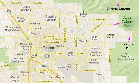
Getting to Agua Caliente Park is easy- just get onto Tanque Verde Road and head east. The turn-offs to the park are well signed.
Click on the photos below for a larger image.
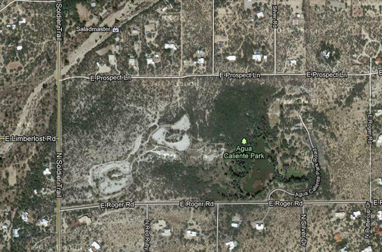
The big picture. Now you can see what the "agua" part of Agua Caliente refers to - water! And anyone who has bought a cup of hot coffee in a disposable cup should know what "caliente" means - hot!
Note the two rounded bare spots to the left of the big green oasis. These are overflow ponds. At one time there was enough flow from the main spring to water both of these ponds. Now the spring has been reduced to a trickle and even the oasis area must be supplemented with pumped groundwater to keep it full.
In 1984, when Pima County acquired the property, the spring flow was sufficient to maintain all three ponds. The flow then was in the 150 gallons per minute range. In June of 2011 it was down to 1.5 gallons per minute. And in 2010, for the first time anybody could remember, the spring completely quit flowing.
It is thought this drop in the spring outflow has been caused by the ongoing drought. Increases in the volume of water pumped from the aquifer may also have an effect on the spring flow.
Regardless, it is not known at this point in time what will need to be done to insure the main oasis area stays watered.
This is a story that is often repeated and I have seen the same results in spring areas around the Austin/San Antonio area and at some spring resorts in the state of Nuevo León, Mexico.

A closer look at the oasis area of the main pool. Once upon a time one could take a path all the way around the pond and walk out to the small island (upper right) on a foot bridge. But as the water has dropped, access has been restricted. The park is day use only and has picnic areas, shaded benches, a nature education center, Audubon Center and a small network of trails. {*The palms are not native to the area.}
* An email from Naturalist Bruce Morgan who is n internationally recognized environmental artist, landscape designer, writer, conservationist, and wilderness explorer suggested these may be the palm species (Washingtonia filifera) aka: Desert Fan Palm, Cotton palm, Arizona Fan Palm and California Fan Palm. After reading over the WikiPedia page I concur. Thanks, Bruce!!

This interpretive sign explains how the water is collected, heated and then makes its way to the surface.
A natural hot spring flows through faults between gneissic rock conglomerate sediment. Current temperature of the spring is approximately 87 degrees Fahrenheit. There were originally two springs, one a "Hot Spring" and the other a "Cold Spring". The two springs produced a water flow of up to 500 gallons per minute. The two springs were blasted in the mid-1930's, creating one spring with a temperature of 72 degrees year round. This reduced the water flow to between 150 and 300 gallons per minute.
The spring was blasted again in the early 1960's by the Myriad Research & Development Corp., which cut the water flow down to a maximum of around 100 to 125 gallons per minute.
During the drought of 2003-4, the water flow from the spring fell as low as 14 gallons per minute, resulting in the drying up of ponds 2 and 3. This forced Pima County to dig a well and install a pump on the property to keep the one remaining lake full. A slightly increased flow rate combined with a wet winter (2004-5) raised the water level sufficiently to fill pond 2. Pond 3 remains dry.Source: Friends of Agua Caliente

This shot was taken near the dry ponds. When the resort was developed, around 3000 trees were planted. In the background you can see snow on the Rincon Mountains.

Bone dry and likely to stay that way.

This is at the north end of the oasis near the causeway. The log in the middle is a favored place for turtles to sun themselves.


I had never before seen these "shaggy manes" on palm trees. It was amazing and to me quite beautiful.


Looking north to the Santa Catalina Mountains.

Although there is no foot access to the park, this historic entrance remains.

The views across the water were gorgeous. And the warm breeze didn't hurt!

Aren't those shaggy palms gorgeous!? Some people don't think so...

Unfortunately, this is how most palms end up. Hideous!

When left in their natural state, palms provide habitat for birds, bats, and numerous species of insects.

This shot clearly shows what the water level was. Note the "clipped" appearance of the hanging palm leaves.

The palms are not the only beautiful old trees at Agua Caliente Park. This couple is sitting next to an old Mesquite tree. Some of the mesquite trees here are over 200 years old.
As you might guess, Mesquite trees, like any native desert tree, are drought tolerant. Mesquite trees have both surficial roots and deep tap roots. Some have been recorded at a depth of 190'.
I was glad I finally got to Agua Caliente Park. If you find yourself in Tucson, be sure to visit.
'Till next time...